File:Ct000725C-wh012 5-Universalis cosmographia secundum Ptholomaei traditionem et Americi Vespucii alioru-m-que lustrationes..png
Jump to navigation
Jump to search
Size of this preview: 800 × 446 pixels. Other resolutions: 320 × 178 pixels | 640 × 357 pixels | 1,024 × 571 pixels | 1,280 × 713 pixels | 2,250 × 1,254 pixels.
Original file (2,250 × 1,254 pixels, file size: 2.59 MB, MIME type: image/png)
Captions
Captions
Add a one-line explanation of what this file represents
Summary[edit]
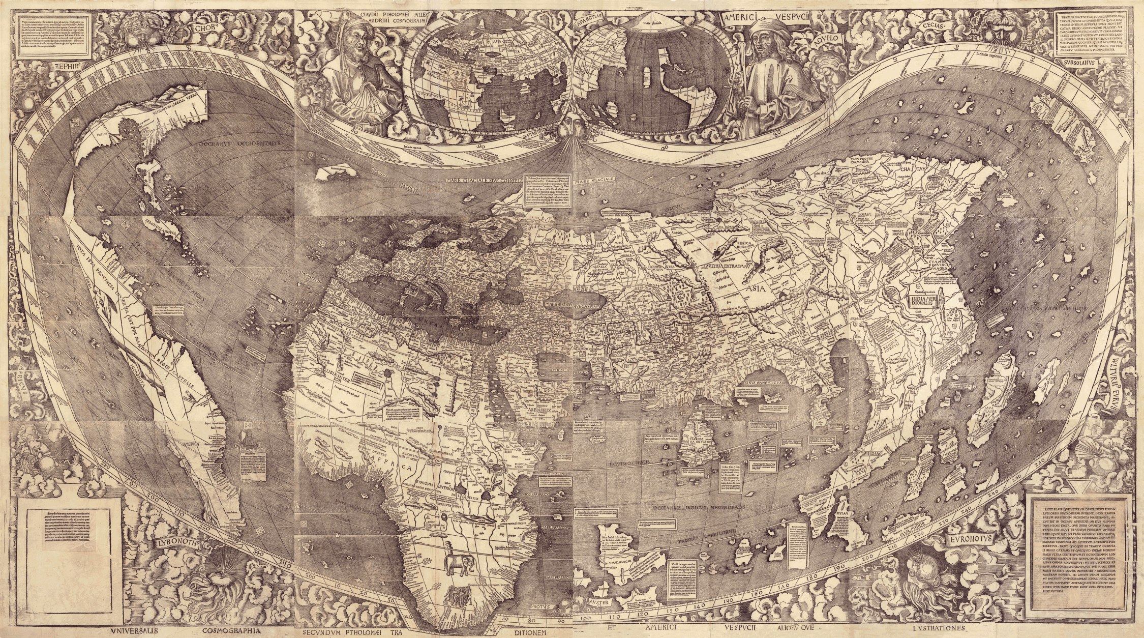
| Martin Waldseemüller: Universalis cosmographia secundum Ptholomaei traditionem et Americi Vespucii alioru[m]que lustrationes.
Universalis cosmographia secundum Ptholomaei traditionem et Americi Vespucii aliorū que lustrationes ( |
||||||||||||||||||||||||
|---|---|---|---|---|---|---|---|---|---|---|---|---|---|---|---|---|---|---|---|---|---|---|---|---|
| Artist |
|
|||||||||||||||||||||||
| Title |
Universalis cosmographia secundum Ptholomaei traditionem et Americi Vespucii alioru[m]que lustrationes. Universalis cosmographia secundum Ptholomaei traditionem et Americi Vespucii aliorū que lustrationes |
|||||||||||||||||||||||
| Date | [St. Dié, France? : s.n., 1507] | |||||||||||||||||||||||
| Medium | 1 map on 12 sheets | |||||||||||||||||||||||
| Dimensions | 128 x 233 cm., sheets 46 x 63 cm. or smaller. | |||||||||||||||||||||||
| Collection |
|
|||||||||||||||||||||||
| Accession number |
|
|||||||||||||||||||||||
| Notes |
|
|||||||||||||||||||||||
| Source/Photographer |
|
|||||||||||||||||||||||


Licensing[edit]
|
This is a faithful photographic reproduction of a two-dimensional, public domain work of art. The work of art itself is in the public domain for the following reason:
The official position taken by the Wikimedia Foundation is that "faithful reproductions of two-dimensional public domain works of art are public domain".
This photographic reproduction is therefore also considered to be in the public domain in the United States. In other jurisdictions, re-use of this content may be restricted; see Reuse of PD-Art photographs for details. | ||||
Original upload log[edit]
| Date/Time | Dimensions | User | Comment |
|---|---|---|---|
| 3 December 2006, 18:49:52 | 2250 × 1254 (2393236 bytes) | Electionworld (talk · contribs) | == Summary == * Bildbeschreibung: Universalis cosmographia secundum Ptholomaei traditionem et Americi Vespucii alioru[m]que lustrationes. :First document known to name [[Amerika|America]]. :Two stamps on verso of upper left hand sheet: Fürstl. [[Waldburg |
File history
Click on a date/time to view the file as it appeared at that time.
| Date/Time | Thumbnail | Dimensions | User | Comment | |
|---|---|---|---|---|---|
| current | 02:44, 4 December 2014 | | 2,250 × 1,254 (2.59 MB) | GifTagger (talk | contribs) | Bot: Converting file to superior PNG file. (Source: [[File:Ct000725C-wh012_5-Universalis_cosmographia_secundum_Ptholomaei_traditionem_et_Americi_Vespucii_alioru-m-que_lustrationes..gif|Ct000725C-wh012_5-Universalis_cosmographia_secu... |
You cannot overwrite this file.
File usage on Commons
The following 9 pages use this file:
- Atlas of Central America
- Atlas of North America
- Atlas of South America
- Joseph Bologne de Saint-George
- Old maps
- Waldseemüller map
- User:AndreasPraefcke/Landkreis Ravensburg new files/2014 December 1-10
- File:Ct000725C-wh012 5-Universalis cosmographia secundum Ptholomaei traditionem et Americi Vespucii alioru-m-que lustrationes..gif (file redirect)
- File:Ct000725C-wh012 5-Universalis cosmographia secundum Ptholomaei traditionem et Americi Vespucii alioru-m-que lustrationes..png
File usage on other wikis
The following other wikis use this file:
- Usage on als.wikipedia.org
- Usage on bs.wikipedia.org
- Usage on de.wikipedia.org
- Usage on en.wikipedia.org
- Usage on fr.wikipedia.org
- Usage on lv.wikipedia.org
- Usage on sv.wikipedia.org