File:Cryptoprocta spelea subfossil range map.svg
Jump to navigation
Jump to search

Size of this PNG preview of this SVG file: 452 × 533 pixels. Other resolutions: 203 × 240 pixels | 407 × 480 pixels | 651 × 768 pixels | 868 × 1,024 pixels | 1,737 × 2,048 pixels.
Original file (SVG file, nominally 452 × 533 pixels, file size: 424 KB)
Captions
Captions
Add a one-line explanation of what this file represents
Summary[edit]
| Description |
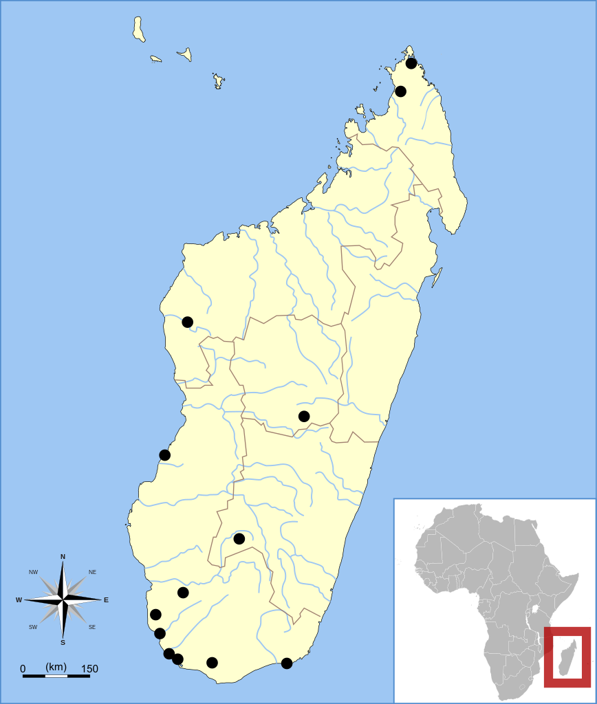
English: Subfossil sites for Cryptoprocta spelea according to the maps of Meador et al. (2017) [1] and Burney et al. (2019) [2].
Notes:
|
| Date | (UTC) |
| Source |
This file was derived from: Cryptoprocta subfossil range map.svg:  |
| Author |
|
This W3C-unspecified vector image was created with Inkscape .
Licensing[edit]
I, the copyright holder of this work, hereby publish it under the following licenses:
| This file is licensed under the Creative Commons Attribution-Share Alike 3.0 Unported license. | ||
| ||
| This licensing tag was added to this file as part of the GFDL licensing update. |

|
Permission is granted to copy, distribute and/or modify this document under the terms of the GNU Free Documentation License, Version 1.2 or any later version published by the Free Software Foundation; with no Invariant Sections, no Front-Cover Texts, and no Back-Cover Texts. A copy of the license is included in the section entitled GNU Free Documentation License. |
You may select the license of your choice.
Original upload log[edit]
This image is a derivative work of the following images:
- File:Cryptoprocta subfossil range map.svg licensed with Cc-by-sa-3.0-migrated, GFDL
- 2010-06-05T05:47:07Z Maky 452x533 (437807 Bytes) {{Information |Description={{en|1=Subfossil sites for ''Cryptoprocta'' species according to: Goodman, S.M., Rasoloarison, R.M. and Ganzhorn, J.U. 2004. [http://www.mnhn.fr/museum/front/medias/publication/1334_z04n1a9.pdf On t
Uploaded with derivativeFX
File history
Click on a date/time to view the file as it appeared at that time.
| Date/Time | Thumbnail | Dimensions | User | Comment | |
|---|---|---|---|---|---|
| current | 08:32, 9 September 2021 | | 452 × 533 (424 KB) | Paranaja (talk | contribs) | == {{int:filedesc}} == {{Information |Description={{en|1=Subfossil sites for ''Cryptoprocta spelea'' species according to the maps of Meador et al. (2017) and Burney et al. (2019). Notes: * For an unknown reason, the Christmas River site is present in Burney et al. (2019) but absent in Meador et al. (2017). In this map, it is included. * For an unknown reason, the Antsirabe site is present in Meador et al. (2017) but absent in Burney et al. (2019). In this map, it is included. * The Beanka s... |
You cannot overwrite this file.
File usage on Commons
There are no pages that use this file.
File usage on other wikis
The following other wikis use this file:
- Usage on fi.wikipedia.org