File:Croatie-parcs-nationaux-fr.svg
Jump to navigation
Jump to search

Size of this PNG preview of this SVG file: 600 × 600 pixels. Other resolutions: 240 × 240 pixels | 480 × 480 pixels | 768 × 768 pixels | 1,024 × 1,024 pixels | 2,048 × 2,048 pixels | 2,400 × 2,400 pixels.
Original file (SVG file, nominally 2,400 × 2,400 pixels, file size: 1.51 MB)
Captions
Captions
Add a one-line explanation of what this file represents
| Description |
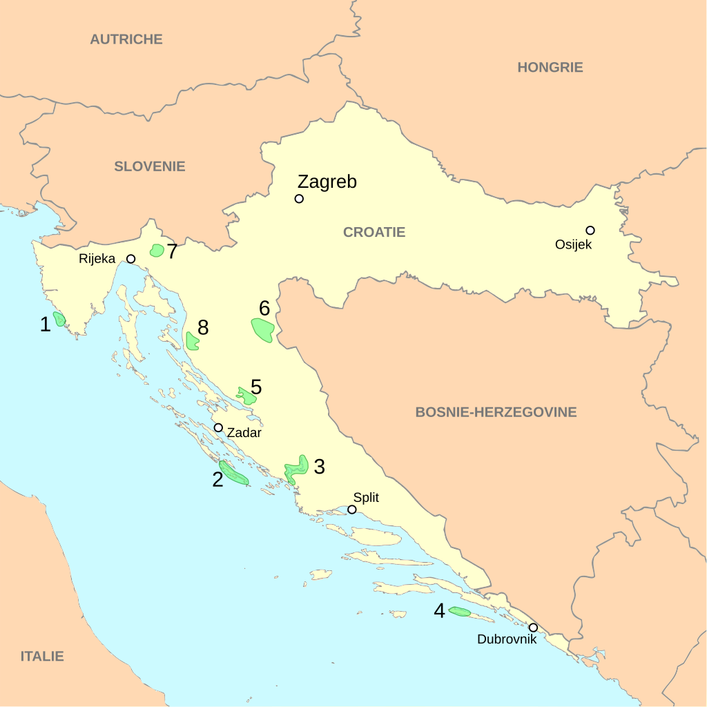
Deutsch: Landkarte mit den Nationalparks in Kroatien am Adriatischen Meer.
English: Localization of Croatian national parks
Français : Localisation des parcs nationaux de Croatie
|
||||||
| Date | |||||||
| Source | travail personnel, à partir du fond de carte Image:Croatia map blank.svg de Minestrone | ||||||
| Author | Cehagenmerak | ||||||
| Permission (Reusing this file) |
This file is licensed under the Creative Commons Attribution 2.5 Generic license.
|
This W3C-unspecified vector image was created with Inkscape .
File history
Click on a date/time to view the file as it appeared at that time.
| Date/Time | Thumbnail | Dimensions | User | Comment | |
|---|---|---|---|---|---|
| current | 04:40, 12 December 2010 | | 2,400 × 2,400 (1.51 MB) | Elekhh (talk | contribs) | correct country label for Austria |
| 23:01, 13 December 2007 |  | 2,400 × 2,400 (1.51 MB) | Cehagenmerak (talk | contribs) | {{Information |Description={{fr|Localisation des parcs nationaux de Croatie}}{{en|Localization of Croatian national parks}} #Brijuni #Kornati #Krka #Mjlet #Paklenica #[[:Category:Plitvice Lakes National P | |
| 22:39, 13 December 2007 |  | 2,400 × 2,400 (1.4 MB) | Cehagenmerak (talk | contribs) | {{Information |Description={{fr|Localisation des parcs nationaux de Croatie}}{{en|Localization of Croatian national parks}} |Source=travail personnel, à partir du fond de carte Image:Croatia map blank.svg de Minestrone |Date=13 D |
You cannot overwrite this file.
File usage on Commons
There are no pages that use this file.
File usage on other wikis
The following other wikis use this file:
- Usage on cs.wikipedia.org
- Usage on fr.wikipedia.org
- Parc national des lacs de Plitvice
- Parc national de Krka
- Parc national de Paklenica
- Modèle:Palette Aires protégées de Croatie
- Parc national de Risnjak
- Parc national de Brioni
- Parc national de Mljet
- Parcs nationaux de Croatie
- Parc national de Sjeverni Velebit
- Parc national des Kornati
- Wikipédia:Atelier graphique/Cartes/Archives/février 2009
- Lonjsko Polje
- Parc naturel de Telašćica
- Kopački Rit
- Parc naturel de Dinara
- Parc naturel de Biokovo
- Usage on is.wikipedia.org
- Usage on sk.wikipedia.org
- Usage on sv.wikipedia.org
- Usage on uk.wikipedia.org