File:Croatia 41 45 en.gif
Jump to navigation
Jump to search
No higher resolution available.
Croatia_41_45_en.gif (600 × 500 pixels, file size: 19 KB, MIME type: image/gif)
Captions
Captions
Add a one-line explanation of what this file represents
Summary[edit]
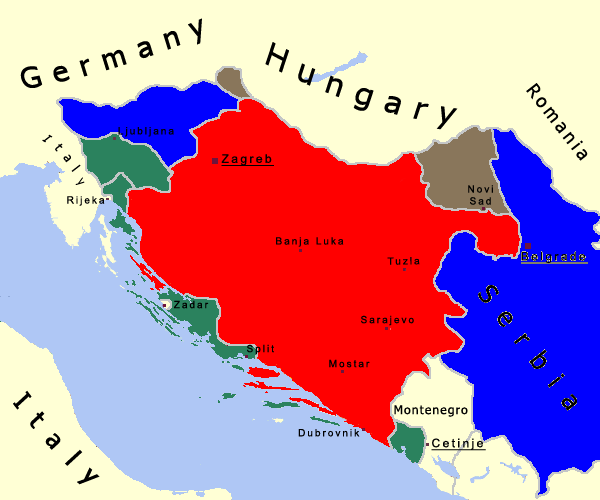
| Description | English map of Indipendent State of Croazia. The red area shows NDH, the green area shows Italian annexations, the brown one shows the Hungarian annexations and the blue one shows the German annexations. |
| Source | Own work |
| Author | Bukkia |
Licensing[edit]
| I, the copyright holder of this work, release this work into the public domain. This applies worldwide. In some countries this may not be legally possible; if so: I grant anyone the right to use this work for any purpose, without any conditions, unless such conditions are required by law. |
| Annotations | This image is annotated: View the annotations at Commons |
File history
Click on a date/time to view the file as it appeared at that time.
| Date/Time | Thumbnail | Dimensions | User | Comment | |
|---|---|---|---|---|---|
| current | 21:51, 14 April 2012 | | 600 × 500 (19 KB) | HistoryBalkans (talk | contribs) | {{Information |Description ={{en|1=-}} |Source =- |Author =- |Date = |Permission = |other_versions = }} |
| 23:21, 28 August 2007 |  | 600 × 500 (18 KB) | Bukkia (talk | contribs) | {{Information |Description=English map of Indipendent State of Croazia. The red area shows NDH, the green area shows Italian annections, the brown one shows the Hungarian annections and the blue one shows the German annections. |Source=self-made |Date= |A |
You cannot overwrite this file.
File usage on Commons
The following 3 pages use this file:
File usage on other wikis
The following other wikis use this file:
- Usage on de.wikipedia.org
- Usage on hr.wikipedia.org
- Usage on ja.wikipedia.org
- Usage on sh.wikipedia.org
- Usage on uk.wikipedia.org