File:Crimea detail map.png
Crimea_detail_map.png (503 × 298 pixels, file size: 21 KB, MIME type: image/png)
Captions
Captions
Summary[edit]
| Description | ||||
| Date | 13 April 2005 (original upload date) | |||
| Source | Transferred from en.wikipedia to Commons. | |||
| Author | The original uploader was ChrisO at English Wikipedia. | |||
| Permission (Reusing this file) |
|
Licensing[edit]
| This image is a map derived from a United Nations map.
Unless stated otherwise, UN maps are to be considered in the public domain. This applies worldwide. UN maps are, in principle, open source material and you can use them in your work or for making your own map. UN requests however that you delete the UN name, logo and reference number upon any modification to the map. Content of your map will be your responsibility. You can state in your publication, if you wish, something like: based on UN map … (map name, map number, revision number and date). See: Geospatial Information Section. And: Geospatial, location data for a better world. |
 |
Original upload log[edit]
- 2005-04-13 02:37 ChisO 503×298 (21504 bytes)
File history
Click on a date/time to view the file as it appeared at that time.
| Date/Time | Thumbnail | Dimensions | User | Comment | |
|---|---|---|---|---|---|
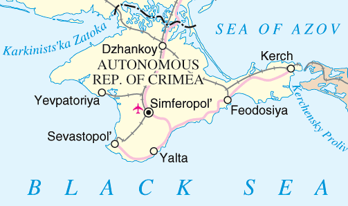
| current | 15:53, 15 November 2007 | | 503 × 298 (21 KB) | Blast (talk | contribs) | {{Information |Description={{en|Map of Crimea, Ukraine.}} |Source=Originally from [http://en.wikipedia.org en.wikipedia]; description page is/was [http://en.wikipedia.org/w/index.php?title=Image:Crimea_detail_map.png here]. |Date=2005-04-13 (origi |
You cannot overwrite this file.
File usage on Commons
There are no pages that use this file.
File usage on other wikis
The following other wikis use this file:
- Usage on sv.wikipedia.org