File:Covent Garden from the Ralph Agas 1572 map of London.jpg
Jump to navigation
Jump to search
Size of this preview: 800 × 536 pixels. Other resolutions: 320 × 214 pixels | 640 × 429 pixels | 821 × 550 pixels.
Original file (821 × 550 pixels, file size: 533 KB, MIME type: image/jpeg)
Captions
Captions
Add a one-line explanation of what this file represents
| Description |
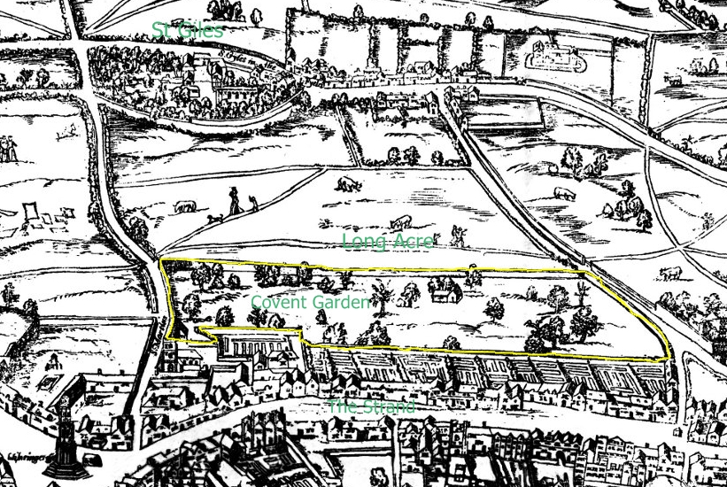
Small detail of the Ralph Agas London map of 1572. Modern marks in green of streets, and in yellow of Covent Garden wall. English: The earliest proper map (as opposed to panorama) of London known. Attributed to Ralph Agas, and probably surveyed between 1570 and 1605. The original was 6 foot 0.5 inches long by 2 feet 4.5 inches wide. This much reduced image is a scan of a copy of a lithograph of a copy, was itself badly repaired with sellotape and has had to be "restored"; so is hardly a truly faithful representation of the original, but few good copies exist and no other detailed public domain images are known. |
| Date | (UTC) |
| Source | |
| Author |
|
| Other versions | Derivative works of this file: Covent Garden from the Ralph Agas 1572 map of London - marked.jpg |
| This is a retouched picture, which means that it has been digitally altered from its original version. Modifications: crop and mark. The original can be viewed here: Civitas Londinium or The Agas Map of London.jpg:
|
I, the copyright holder of this work, hereby publish it under the following license:
| I, the copyright holder of this work, release this work into the public domain. This applies worldwide. In some countries this may not be legally possible; if so: I grant anyone the right to use this work for any purpose, without any conditions, unless such conditions are required by law. |
Original upload log[edit]
This image is a derivative work of the following images:
- File:Civitas_Londinium_or_The_Agas_Map_of_London.jpg licensed with PD-self
- 2009-08-14T18:59:27Z MikeCalder 4730x2000 (4275796 Bytes) {{Information |Description={{en|1=The earliest proper map (as opposed to panorama) of London known. Attributed to Ralph Agas, and probably surveyed between 1570 and 1605. The original was 6 foot 0.5 inches long by 2 feet 4.5
Uploaded with derivativeFX
File history
Click on a date/time to view the file as it appeared at that time.
| Date/Time | Thumbnail | Dimensions | User | Comment | |
|---|---|---|---|---|---|
| current | 18:15, 12 August 2010 | | 821 × 550 (533 KB) | SilkTork (talk | contribs) | {{Information |Description=Small detail of the Ralph Agas London map of 1572. Modern marks in green of streets, and in yellow of Covent Garden wall. {{en|1=The earliest proper map (as opposed to panorama) of London known. Attributed to Ralph Agas, and p |
You cannot overwrite this file.
File usage on Commons
The following page uses this file: