File:Countries that use Fahrenheit.svg
Jump to navigation
Jump to search

Size of this PNG preview of this SVG file: 800 × 411 pixels. Other resolutions: 320 × 164 pixels | 640 × 329 pixels | 1,024 × 526 pixels | 1,280 × 657 pixels | 2,560 × 1,314 pixels.
Original file (SVG file, nominally 2,560 × 1,314 pixels, file size: 1.05 MB)
Captions
Captions
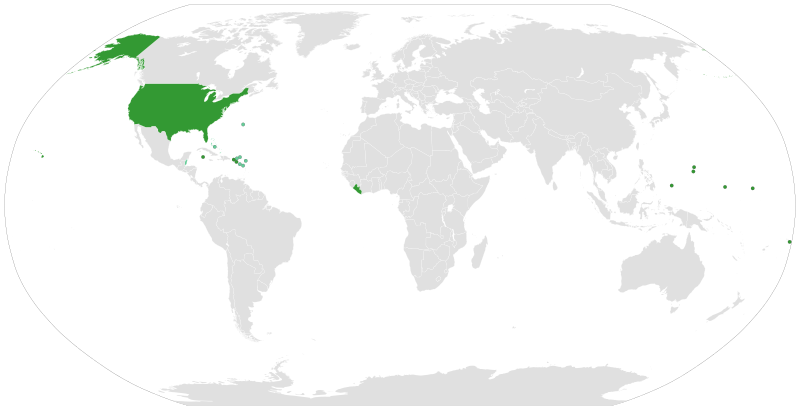
Map of countries that have yet to discover Celsius
Summary[edit]
| Description |
English: Use of the Fahrenheit system of measuring temperatures
Countries which officially use Fahrenheit
Countries which use both systems at the same time
Countries which officially use Celsius Italiano: Uso della scala termometrica Fahrenheit
Paesi che usano ufficialmente la scala Fahrenheit
Paesi che usano entrambe le scale
Paesi che usano ufficialmente la scala Celsius Nederlands: Gebruik van de Fahrenheit-schaal om temperaturen te meten
Landen die de Fahrenheit-schaal gebruiken
Landen die allebei de schalen gebruiken
Landen die de Celsius-schaal gebruiken Svenska: Användandet av Fahrenheit-systemet för mätning av temperatur
Länder använder sig av Fahrenheit
Länder som använder båda systemen
Länder använder sig av Celsius |
| Date | |
| Source |
This vector image includes elements that have been taken or adapted from this file: |
| Author |
|
| SVG development | This vector image was created with a text editor. |
Licensing[edit]
I, the copyright holder of this work, hereby publish it under the following license:
This file is licensed under the Creative Commons Attribution-Share Alike 4.0 International license.
- You are free:
- to share – to copy, distribute and transmit the work
- to remix – to adapt the work
- Under the following conditions:
- attribution – You must give appropriate credit, provide a link to the license, and indicate if changes were made. You may do so in any reasonable manner, but not in any way that suggests the licensor endorses you or your use.
- share alike – If you remix, transform, or build upon the material, you must distribute your contributions under the same or compatible license as the original.
File history
Click on a date/time to view the file as it appeared at that time.
| Date/Time | Thumbnail | Dimensions | User | Comment | |
|---|---|---|---|---|---|
| current | 11:39, 29 December 2019 | | 2,560 × 1,314 (1.05 MB) | Carnby (talk | contribs) | Updated Turks and Caicos |
| 17:43, 10 July 2019 |  | 2,560 × 1,314 (1.05 MB) | Carnby (talk | contribs) | Updated Bahamas | |
| 18:22, 1 October 2018 |  | 2,560 × 1,314 (1.05 MB) | Carnby (talk | contribs) | Belize now uses both measurement systems | |
| 20:22, 17 September 2018 |  | 2,560 × 1,314 (1.05 MB) | Carnby (talk | contribs) | Also Turks and Caicos in official weather reports use both Fahrenheit and Celsius | |
| 19:10, 17 September 2018 |  | 2,560 × 1,314 (1.05 MB) | Carnby (talk | contribs) | Also Turks and Caicos Islands use Fahrenheit; Bermuda, Antigua and Barbuda and other islands which use the same meteorological service (Anguilla, British Virgin Islands, Montserrat and Saint Kitts and Nevis) use both Fahrenheit and Celsius | |
| 17:23, 17 September 2018 |  | 2,560 × 1,314 (1.05 MB) | Carnby (talk | contribs) | British West Indies still use Fahrenheit (although Bermuda uses also Celsius) | |
| 15:06, 16 September 2018 |  | 2,560 × 1,314 (1.05 MB) | Carnby (talk | contribs) | Updated; Myanmar uses Celsius now; circles around small countries (if you want to revert please write me first) | |
| 16:03, 1 February 2018 |  | 1,650 × 750 (748 KB) | TysonB15 (talk | contribs) | Reverted to version as of 16:48, 19 January 2016 (UTC) due to higher resolution, transparency, and shading of regions instead of green dots. | |
| 20:25, 28 December 2016 |  | 940 × 415 (1.45 MB) | Carnby (talk | contribs) | Reverted to version as of 19:45, 28 December 2016 (UTC) | |
| 20:23, 28 December 2016 |  | 940 × 415 (1.45 MB) | Carnby (talk | contribs) | Belize |
You cannot overwrite this file.
File usage on Commons
There are no pages that use this file.
File usage on other wikis
The following other wikis use this file:
- Usage on af.wikipedia.org
- Usage on an.wikipedia.org
- Usage on ar.wikipedia.org
- Usage on ast.wikipedia.org
- Usage on az.wikipedia.org
- Usage on be-tarask.wikipedia.org
- Usage on be.wikipedia.org
- Usage on bg.wikipedia.org
- Usage on ca.wikipedia.org
- Usage on cs.wikipedia.org
- Usage on da.wikipedia.org
- Usage on el.wikipedia.org
- Usage on en.wikipedia.org
- Usage on eo.wikipedia.org
- Usage on es.wikipedia.org
- Usage on eu.wikipedia.org
- Usage on fa.wikipedia.org
- Usage on fi.wikipedia.org
- Usage on fo.wikipedia.org
- Usage on frr.wikipedia.org
- Usage on fr.wikipedia.org
- Usage on fy.wikipedia.org
- Usage on gl.wikipedia.org
- Usage on he.wikipedia.org
- Usage on hi.wikipedia.org
- Usage on hy.wikipedia.org
- Usage on ia.wikipedia.org
- Usage on id.wikipedia.org
- Usage on is.wikipedia.org
- Usage on it.wikipedia.org
- Usage on jam.wikipedia.org
- Usage on ja.wikipedia.org
- Usage on ka.wikipedia.org
- Usage on kn.wikipedia.org
- Usage on ko.wikipedia.org
- Usage on ku.wikipedia.org
- Usage on lb.wikipedia.org
- Usage on lv.wikipedia.org
- Usage on mk.wikipedia.org
- Usage on ml.wikipedia.org
- Usage on mr.wikipedia.org
- Usage on ms.wikipedia.org
View more global usage of this file.