File:Countries driving on the left or right 1900.svg
Jump to navigation
Jump to search

Size of this PNG preview of this SVG file: 800 × 406 pixels. Other resolutions: 320 × 162 pixels | 640 × 325 pixels | 1,024 × 520 pixels | 1,280 × 650 pixels | 2,560 × 1,299 pixels | 940 × 477 pixels.
Original file (SVG file, nominally 940 × 477 pixels, file size: 1.65 MB)
Captions
Captions
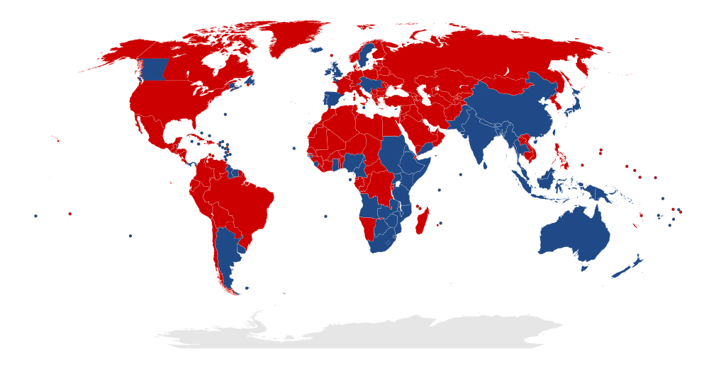
Countries driving on the left or right hand side of the road, early 1900s
Summary[edit]
| Description |
English: Countries driving on the left or right hand side of the road, early 20th Century |
| Date | |
| Source | Own work |
| Author | Cornellier |
| Other versions | Based on File:Countries driving on the left or right.svg |
Licensing[edit]
I, the copyright holder of this work, hereby publish it under the following license:
This file is licensed under the Creative Commons Attribution-Share Alike 4.0 International license.
- You are free:
- to share – to copy, distribute and transmit the work
- to remix – to adapt the work
- Under the following conditions:
- attribution – You must give appropriate credit, provide a link to the license, and indicate if changes were made. You may do so in any reasonable manner, but not in any way that suggests the licensor endorses you or your use.
- share alike – If you remix, transform, or build upon the material, you must distribute your contributions under the same or compatible license as the original.
File history
Click on a date/time to view the file as it appeared at that time.
| Date/Time | Thumbnail | Dimensions | User | Comment | |
|---|---|---|---|---|---|
| current | 18:47, 3 August 2019 | | 940 × 477 (1.65 MB) | Slashme (talk | contribs) | Belize was on the left in 1900. |
| 20:40, 22 July 2019 |  | 940 × 477 (1.65 MB) | Slashme (talk | contribs) | Uruguay and Argentina on left. | |
| 12:16, 21 July 2019 |  | 940 × 477 (1.67 MB) | Slashme (talk | contribs) | Correction: South Yemen | |
| 12:13, 21 July 2019 |  | 940 × 477 (1.67 MB) | Slashme (talk | contribs) | Correction: Sudan is all blue. | |
| 12:06, 21 July 2019 |  | 940 × 477 (1.67 MB) | Slashme (talk | contribs) | More updates from talk. | |
| 11:00, 21 July 2019 |  | 940 × 477 (1.72 MB) | Slashme (talk | contribs) | Corrections suggested by User:Matricatria on my talk page | |
| 23:22, 10 October 2016 |  | 940 × 477 (1.77 MB) | Cornellier (talk | contribs) | User created page with UploadWizard |
You cannot overwrite this file.
File usage on Commons
The following 6 pages use this file:
- User:Chumwa/OgreBot/Potential transport maps/2019 August 1-10
- User:Chumwa/OgreBot/Potential transport maps/2019 July 21-31
- User:Chumwa/OgreBot/Transport Maps/2019 August 1-10
- User:Chumwa/OgreBot/Transport Maps/2019 July 21-31
- User:Chumwa/OgreBot/Travel and communication maps/2019 August 1-10
- User:Chumwa/OgreBot/Travel and communication maps/2019 July 21-31
File usage on other wikis
The following other wikis use this file:
- Usage on th.wikipedia.org