File:Countries driving on the left or right, uses kilometers or miles.png
Jump to navigation
Jump to search
Size of this preview: 800 × 406 pixels. Other resolutions: 320 × 162 pixels | 640 × 325 pixels | 1,024 × 520 pixels | 2,000 × 1,015 pixels.
Original file (2,000 × 1,015 pixels, file size: 296 KB, MIME type: image/png)
Captions
Captions
Add a one-line explanation of what this file represents
Summary[edit]

|
File:Countries driving on the left or right, uses kilometers or miles.svg is a vector version of this file. It should be used in place of this PNG file when not inferior.
File:Countries driving on the left or right, uses kilometers or miles.png → File:Countries driving on the left or right, uses kilometers or miles.svg
For more information, see Help:SVG. |
 |
| Description |
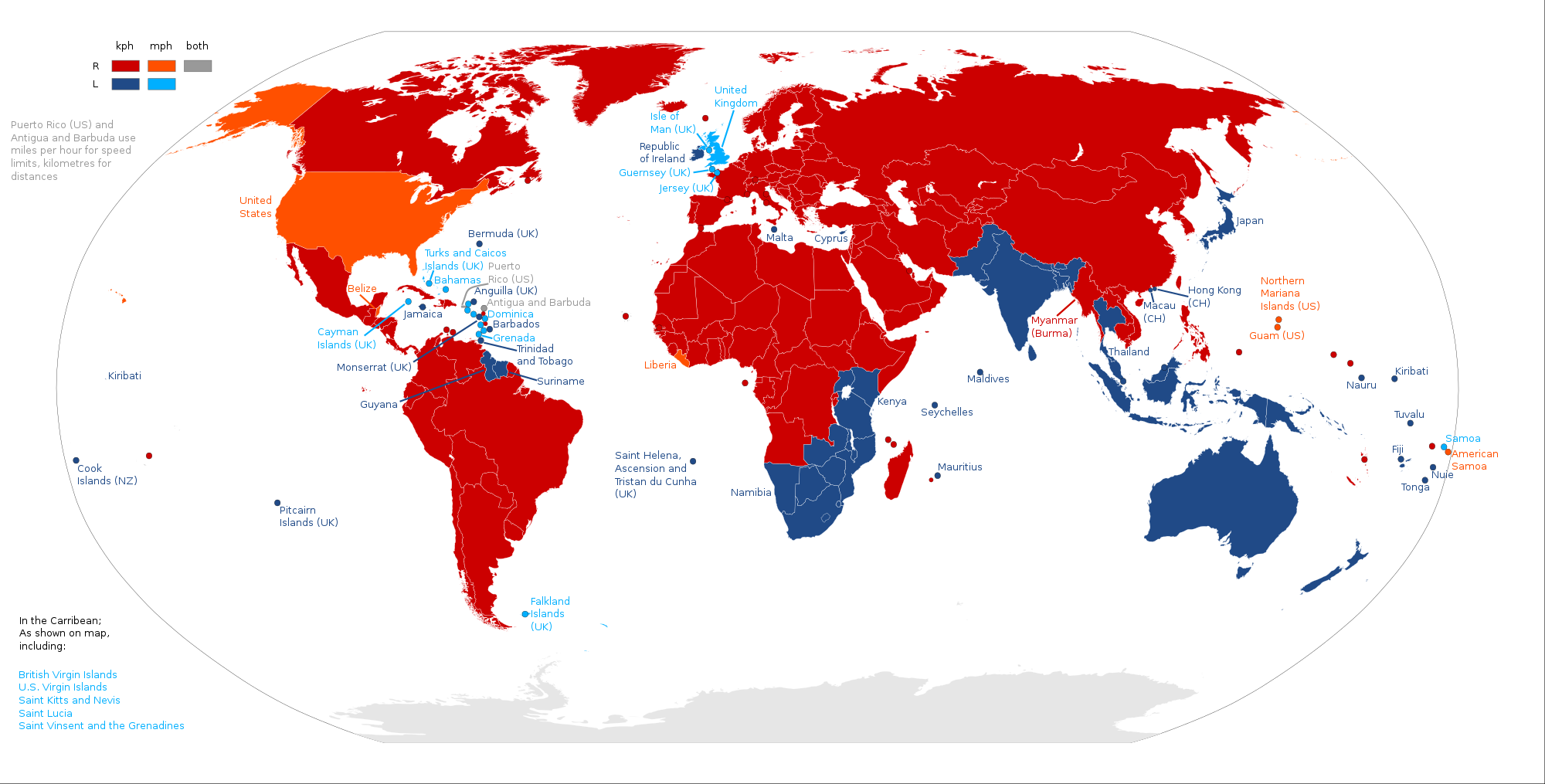
English: A map indicating which countries drive on the right side of the road, and which drive on the left side, coupled with whether they use kilometers as a distance/speed unit, or miles.
Right-hand traffic, kilometers
Right-hand traffic, miles
Right-hand traffic, miles per hour (for speed limits) and kilometers (for distances)
Left-hand traffic, kilometers
Left-hand traffic, miles |
| Date | |
| Source | Own work |
| Author | TesterABV |
| Other versions |
|

Licensing[edit]
I, the copyright holder of this work, hereby publish it under the following license:
This file is licensed under the Creative Commons Attribution-Share Alike 4.0 International license.
- You are free:
- to share – to copy, distribute and transmit the work
- to remix – to adapt the work
- Under the following conditions:
- attribution – You must give appropriate credit, provide a link to the license, and indicate if changes were made. You may do so in any reasonable manner, but not in any way that suggests the licensor endorses you or your use.
- share alike – If you remix, transform, or build upon the material, you must distribute your contributions under the same or compatible license as the original.
File history
Click on a date/time to view the file as it appeared at that time.
| Date/Time | Thumbnail | Dimensions | User | Comment | |
|---|---|---|---|---|---|
| current | 18:30, 3 July 2019 | | 2,000 × 1,015 (296 KB) | Maphobbyist (talk | contribs) | SVG quality |
| 13:45, 30 June 2019 |  | 2,000 × 1,015 (364 KB) | Delusion23 (talk | contribs) | Myanmar kph since 2013 http://metricviews.org.uk/2018/02/metric-in-myanmar-an-update/ | |
| 23:18, 1 April 2019 |  | 2,000 × 1,015 (364 KB) | Buckaroo bob 91 (talk | contribs) | Reverted to version as of 21:51, 11 May 2016 (UTC) | |
| 01:56, 1 April 2019 |  | 331 × 271 (26 KB) | Buckaroo bob 91 (talk | contribs) | Cropped 83 % horizontally, 73 % vertically using CropTool with precise mode. | |
| 21:51, 11 May 2016 |  | 2,000 × 1,015 (364 KB) | Delusion23 (talk | contribs) | Guernsey and Jersey mixed up | |
| 21:47, 11 May 2016 |  | 2,000 × 1,015 (364 KB) | Delusion23 (talk | contribs) | Suriname and Guyana wrong way round | |
| 19:18, 27 January 2016 |  | 2,000 × 1,015 (329 KB) | TesterABV (talk | contribs) | User created page with UploadWizard |
You cannot overwrite this file.
File usage on Commons
The following 11 pages use this file:
- User:Chumwa/OgreBot/Potential transport maps/2019 April 1-10
- User:Chumwa/OgreBot/Potential transport maps/2019 July 1-10
- User:Chumwa/OgreBot/Potential transport maps/2019 June 21-30
- User:Chumwa/OgreBot/Transport Maps/2019 April 1-10
- User:Chumwa/OgreBot/Transport Maps/2019 July 1-10
- User:Chumwa/OgreBot/Transport Maps/2019 June 21-30
- User:Chumwa/OgreBot/Travel and communication maps/2019 April 1-10
- User:Chumwa/OgreBot/Travel and communication maps/2019 July 1-10
- User:Chumwa/OgreBot/Travel and communication maps/2019 June 21-30
- File:Countries driving on the left or right, uses kilometers or miles.svg
- File:Japans driving side vs its closest neighbors.png
File usage on other wikis
The following other wikis use this file:
- Usage on fa.wikipedia.org
- Usage on so.wikipedia.org
- Usage on th.wikipedia.org