File:Countries & Territories by estimated PPP GDP in 2020.png
Jump to navigation
Jump to search

Size of this preview: 800 × 393 pixels. Other resolutions: 320 × 157 pixels | 640 × 314 pixels | 1,024 × 503 pixels | 1,280 × 629 pixels | 2,560 × 1,258 pixels | 6,300 × 3,095 pixels.
Original file (6,300 × 3,095 pixels, file size: 1.63 MB, MIME type: image/png)
Captions
Captions
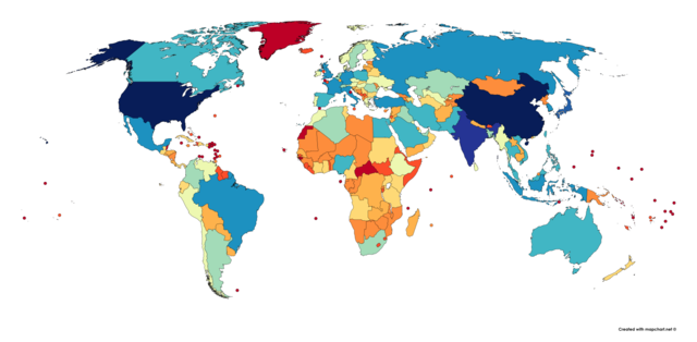
A map showing the countries & territories of the world by their estimated PPP GDP in 2020 using the IMF database and CIA World Factbook
Summary
[edit]
| Description |
English: This is a map showing the countries & territories of the world by their estimated PPP GDP in 2020. I used the IMF's April 2020 WEO Database for most countries and dependencies, but for those without data, I used the latest data available from the CIA World Factbook (for North Korea, Venezuela, Cuba, Greenland, and tons of small island nations and territories. I made the map at mapchart.net |
| Date | |
| Source | Own work |
| Author | User:Abbasi786786 |
Licensing
[edit]
I, the copyright holder of this work, hereby publish it under the following license:
This file is licensed under the Creative Commons Attribution-Share Alike 4.0 International license.
- You are free:
- to share – to copy, distribute and transmit the work
- to remix – to adapt the work
- Under the following conditions:
- attribution – You must give appropriate credit, provide a link to the license, and indicate if changes were made. You may do so in any reasonable manner, but not in any way that suggests the licensor endorses you or your use.
- share alike – If you remix, transform, or build upon the material, you must distribute your contributions under the same or compatible license as the original.
File history
Click on a date/time to view the file as it appeared at that time.
| Date/Time | Thumbnail | Dimensions | User | Comment | |
|---|---|---|---|---|---|
| current | 20:51, 23 April 2020 | | 6,300 × 3,095 (1.63 MB) | Abbasi786786 (talk | contribs) | Uploaded own work with UploadWizard |
You cannot overwrite this file.
File usage on Commons
There are no pages that use this file.
File usage on other wikis
The following other wikis use this file:
- Usage on sv.wikipedia.org
- Usage on tr.wikipedia.org
- Usage on uk.wikipedia.org
- Usage on zh-yue.wikipedia.org