File:CountriesRecognizingKosovoOrder.png
Jump to navigation
Jump to search

Size of this preview: 800 × 370 pixels. Other resolutions: 320 × 148 pixels | 640 × 296 pixels | 1,357 × 628 pixels.
Original file (1,357 × 628 pixels, file size: 40 KB, MIME type: image/png)
Captions
Captions
Add a one-line explanation of what this file represents
Summary[edit]
| Description |
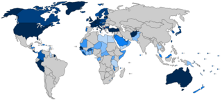
English: Map showing the order in which countries recognized Kosovo's independence. Darker shades mean earlier recognition. The darkest shade is for those who recognized within the first week of independence (i.e. until 25 Feb 2008) The next darkest shade: through to 20 March 2008 (the 31st day of Kosovo's independence) Next darkest shade: through to 18 August 2008 (Kosovo's half birthday) After this point, each new shade is applied at each of Kosovo's birthdays, until Kosovo's sixth birthday in 2014, after which the shade is not changed. |
| Date | |
| Source | Own work |
| Author | Yalens |
| Other versions | File:Kosovo recognition years.png |
Licensing[edit]
I, the copyright holder of this work, hereby publish it under the following license:
This file is licensed under the Creative Commons Attribution-Share Alike 3.0 Unported license.
- You are free:
- to share – to copy, distribute and transmit the work
- to remix – to adapt the work
- Under the following conditions:
- attribution – You must give appropriate credit, provide a link to the license, and indicate if changes were made. You may do so in any reasonable manner, but not in any way that suggests the licensor endorses you or your use.
- share alike – If you remix, transform, or build upon the material, you must distribute your contributions under the same or compatible license as the original.
File history
Click on a date/time to view the file as it appeared at that time.
| Date/Time | Thumbnail | Dimensions | User | Comment | |
|---|---|---|---|---|---|
| current | 19:01, 23 April 2014 | | 1,357 × 628 (40 KB) | EmilJ (talk | contribs) | +Tonga, +Lesotho, -Nigeria |
| 16:47, 30 September 2013 |  | 1,357 × 628 (40 KB) | EmilJ (talk | contribs) | +Thailand, Libya, Grenada | |
| 14:03, 16 August 2013 |  | 1,357 × 628 (40 KB) | EmilJ (talk | contribs) | +El Salvador | |
| 17:08, 26 June 2013 |  | 1,357 × 628 (40 KB) | EmilJ (talk | contribs) | +Egypt | |
| 15:12, 17 June 2013 |  | 1,357 × 628 (40 KB) | EmilJ (talk | contribs) | +Yemen | |
| 12:12, 7 June 2013 |  | 1,357 × 628 (40 KB) | EmilJ (talk | contribs) | +Tanzania | |
| 16:28, 25 March 2013 |  | 1,357 × 628 (40 KB) | EmilJ (talk | contribs) | +Guyana | |
| 20:24, 29 December 2012 |  | 1,357 × 628 (62 KB) | Bazonka (talk | contribs) | You forgot Swaziland | |
| 03:34, 29 December 2012 |  | 1,357 × 628 (62 KB) | Calthinus (talk | contribs) | Fixed Colombia and Belize, because I decided to make the boundary the half-birthday instead of the third-birthday. | |
| 23:45, 28 December 2012 |  | 1,357 × 628 (62 KB) | Calthinus (talk | contribs) | User created page with UploadWizard |
You cannot overwrite this file.
File usage on Commons
There are no pages that use this file.
File usage on other wikis
The following other wikis use this file:
- Usage on en.wikipedia.org