File:Cornubian batholith.png
Jump to navigation
Jump to search

Size of this preview: 800 × 479 pixels. Other resolutions: 320 × 192 pixels | 640 × 383 pixels | 1,024 × 613 pixels | 1,471 × 881 pixels.
Original file (1,471 × 881 pixels, file size: 480 KB, MIME type: image/png)
Captions
Captions
Add a one-line explanation of what this file represents
Summary[edit]
| Description |
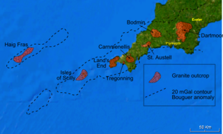
English: Map of the Cornubian batholith and the Haig Fras granite, outcrops taken from various published maps and 20 mGal Bouguer gravity contour taken from Edwards 1984 [1] and Taylor 2007 [2] - base is a snapshot from NASA World Wind software. The granite intrusions are lower in density than the average for the upper part of the continental crust and therefore show up as a negative anomaly where the observed gravitational field has been corrected for the effects of topography (the Bouguer correction). The 20 mGal contour is there to show the extent of this negative anomaly. |
| Date | |
| Source | Own work |
| Author | Mikenorton |
Licensing[edit]
I, the copyright holder of this work, hereby publish it under the following licenses:
This file is licensed under the Creative Commons Attribution-Share Alike 3.0 Unported license.
- You are free:
- to share – to copy, distribute and transmit the work
- to remix – to adapt the work
- Under the following conditions:
- attribution – You must give appropriate credit, provide a link to the license, and indicate if changes were made. You may do so in any reasonable manner, but not in any way that suggests the licensor endorses you or your use.
- share alike – If you remix, transform, or build upon the material, you must distribute your contributions under the same or compatible license as the original.

|
Permission is granted to copy, distribute and/or modify this document under the terms of the GNU Free Documentation License, Version 1.2 or any later version published by the Free Software Foundation; with no Invariant Sections, no Front-Cover Texts, and no Back-Cover Texts. A copy of the license is included in the section entitled GNU Free Documentation License. |
You may select the license of your choice.
File history
Click on a date/time to view the file as it appeared at that time.
| Date/Time | Thumbnail | Dimensions | User | Comment | |
|---|---|---|---|---|---|
| current | 00:49, 17 January 2011 | | 1,471 × 881 (480 KB) | Mikenorton (talk | contribs) | Corrected spelling of Carnmenellis |
| 23:30, 4 January 2011 |  | 1,471 × 881 (480 KB) | Mikenorton (talk | contribs) | {{Information |Description={{en|1=Map of the Cornubian batholith and the Haig Fras granite, outcrops taken from various published maps and 20 mGal Bouguer gravity contour taken from Edwards 1984 [http://sp.lyellcollection.org/cgi/content/abstract/14/1/119 |
You cannot overwrite this file.
File usage on Commons
The following page uses this file:
File usage on other wikis
The following other wikis use this file:
- Usage on de.wikipedia.org
- Usage on en.wikipedia.org
- Usage on es.wikipedia.org
- Usage on gl.wikipedia.org
- Usage on pt.wikipedia.org
- Usage on sl.wikipedia.org
- Usage on vi.wikipedia.org