File:Cornubian Batholith.svg
Jump to navigation
Jump to search

Size of this PNG preview of this SVG file: 800 × 425 pixels. Other resolutions: 320 × 170 pixels | 640 × 340 pixels | 1,024 × 544 pixels | 1,280 × 680 pixels | 2,560 × 1,359 pixels | 1,390 × 738 pixels.
Original file (SVG file, nominally 1,390 × 738 pixels, file size: 72 KB)
Captions
Captions
Add a one-line explanation of what this file represents
Summary[edit]
| Description |
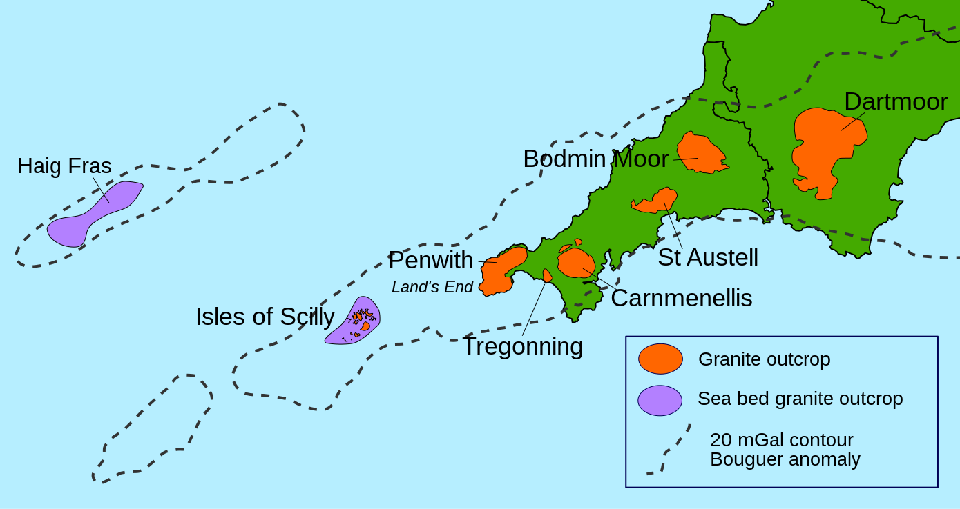
English: Map of the Cornubian batholith and the Haig Fras granite, outcrops taken from various published maps and 20 mGal Bouguer gravity contour taken from Edwards 1984 [1] and Taylor 2007 [2]. The granite intrusions are lower in density than the average for the upper part of the continental crust and therefore show up as a negative anomaly where the observed gravitational field has been corrected for the effects of topography (the Bouguer correction). The 20 mGal contour is there to show the extent of this negative anomaly. |
||
| Date | |||
| Source | |||
| Author | |||
| Permission (Reusing this file) |
I, the copyright holder of this work, hereby publish it under the following licenses: This file is licensed under the Creative Commons Attribution-Share Alike 3.0 Unported license.
You may select the license of your choice. |
||
| Other versions | File:Cornubian batholith.png |

File history
Click on a date/time to view the file as it appeared at that time.
| Date/Time | Thumbnail | Dimensions | User | Comment | |
|---|---|---|---|---|---|
| current | 23:17, 23 February 2015 | | 1,390 × 738 (72 KB) | Hogweard (talk | contribs) | {{Information |Description=={{en|1=Map of the Cornubian batholith and the Haig Fras granite, outcrops taken from various published maps and 20 mGal Bouguer gravity contour taken from Edwards 1984 [http://sp.lyellcollection.org/cgi/content/abstract/14/1... |
You cannot overwrite this file.
File usage on Commons
There are no pages that use this file.
File usage on other wikis
The following other wikis use this file:
- Usage on de.wikipedia.org
- Usage on en.wikipedia.org
- Usage on kw.wikipedia.org
Metadata
Categories:
- Maps of South West England
- Geological maps of England
- Cornubian Batholith
- Granite formations in the United Kingdom
- Gravimetric maps
- Geological maps of Cornwall
- Carnmenellis Granite
- Dartmoor Granite
- Tregonning Granite
- Land's End Granite
- Scilly Granite
- Granite formations in Cornwall
- Igneous intrusions in Cornwall