File:Coreca amantea calabria 02.jpg
Coreca_amantea_calabria_02.jpg (400 × 400 pixels, file size: 43 KB, MIME type: image/jpeg)
Captions
Captions
Summary
[edit]
| Description |
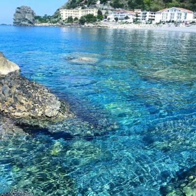
Italiano: Scoglio di Coreca di Amantea CS - Calabria
Si affaccia a ovest sul mar Tirreno meridionale ed è circondato dal capoluogo comunale di Amantea fino a sud, ove inizia il confine con Campora San Giovanni. Il territorio consiste principalmente in un promontorio roccioso; nella parte pianeggiante sorge il centro cittadino. Comprende anche una zona collinare e ampie spiagge. Il clima è mite.Español: Acantilado de Coreca desde Amantea CS - Calabria
Está orientada al oeste de la parte sur del mar Tirreno y está rodeado por la ciudad capital de Amantea hacia el sur, donde empieza la frontera con Campora San Giovanni. El territorio consiste principalmente en un promontorio rocoso; en la llanura se encuentra el centro de la ciudad. También incluye las amplias playas, colinas. El clima es templado.Deutsch: Klippe von Coreca von Amantea CS - Calabria
Es ist mit Blick nach Westen auf der südlichen Tyrrhenischen Meer und ist von der Hauptstadt von Amantea nach Süden umgeben, wo die Grenze zu Campora San Giovanni beginnt. Das Gebiet besteht hauptsächlich aus einem Felsvorsprung ; in der Ebene liegt das Stadtzentrum . Es beinhaltet auch die hügelige, weite Strände. Das Klima ist mild.English: Cliff of Coreca from Amantea CS - Calabria
It is facing west on the southern Tyrrhenian Sea and is surrounded by the capital city of Amantea to the south, where begins the border with Campora San Giovanni. The territory consists mainly of a rocky promontory; in the plain lies the city center. It also includes the hilly, wide beaches. The climate is mild.
|
||
| Date | |||
| Source | Own work | ||
| Author | Stefanocaruso1984 |
| Camera location | | View this and other nearby images on: OpenStreetMap |
|---|
Il territorio consiste principalmente in un promontorio roccioso; nella parte pianeggiante sorge il centro cittadino. Comprende anche una zona collinare e ampie spiagge. Il clima è mite.
Licensing
[edit]
- You are free:
- to share – to copy, distribute and transmit the work
- to remix – to adapt the work
- Under the following conditions:
- attribution – You must give appropriate credit, provide a link to the license, and indicate if changes were made. You may do so in any reasonable manner, but not in any way that suggests the licensor endorses you or your use.
- share alike – If you remix, transform, or build upon the material, you must distribute your contributions under the same or compatible license as the original.

|
This image was uploaded as part of Wiki Loves Monuments 2016.
|
 |
File history
Click on a date/time to view the file as it appeared at that time.
| Date/Time | Thumbnail | Dimensions | User | Comment | |
|---|---|---|---|---|---|
| current | 17:20, 22 September 2016 | | 400 × 400 (43 KB) | Stefanocaruso1984 (talk | contribs) | User created page with UploadWizard |
You cannot overwrite this file.
File usage on Commons
There are no pages that use this file.