File:Copenhagen bus line 9A 2019.png
Jump to navigation
Jump to search
No higher resolution available.
Copenhagen_bus_line_9A_2019.png (700 × 500 pixels, file size: 483 KB, MIME type: image/png)
Captions
Captions
Add a one-line explanation of what this file represents
Summary[edit]
| Description |
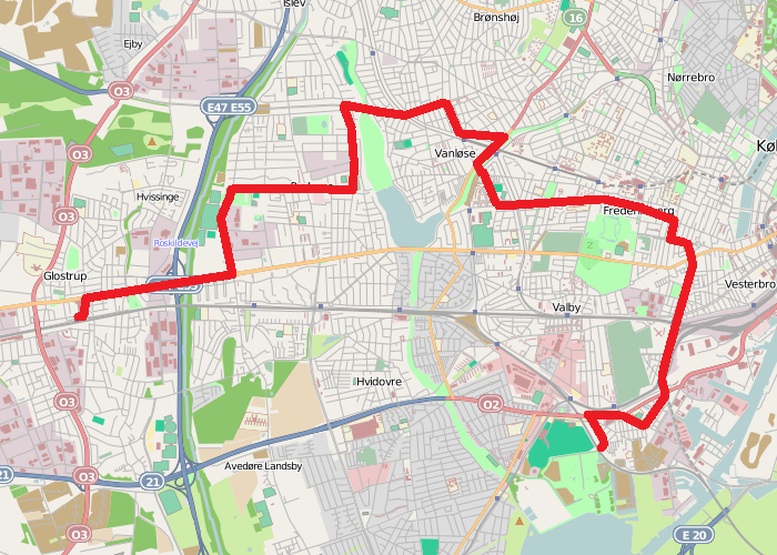
English: Map of the Copenhagen bus line 9A between Glostrup Station and Valbyparken as of 13 October 2019. |
| Date | |
| Source | Own work based on File:Map of Copenhagen with surroundings.png |
| Author | Leif Jørgensen |
Licensing[edit]
I, the copyright holder of this work, hereby publish it under the following license:
This file is licensed under the Creative Commons Attribution-Share Alike 2.0 Generic license.
- You are free:
- to share – to copy, distribute and transmit the work
- to remix – to adapt the work
- Under the following conditions:
- attribution – You must give appropriate credit, provide a link to the license, and indicate if changes were made. You may do so in any reasonable manner, but not in any way that suggests the licensor endorses you or your use.
- share alike – If you remix, transform, or build upon the material, you must distribute your contributions under the same or compatible license as the original.
| Description |
This map was created from OpenStreetMap project data, collected by the community. This map may be incomplete, and may contain errors. Don't rely solely on it for navigation. |
|||
| Date | (see file history) | |||
| Source | openstreetmap.org | |||
| Creator |
OpenStreetMap contributors |
|||
| Permission (Reusing this file) |
OpenStreetMap data is available under the Open Database License (details). Map tiles are licensed under the Creative Commons Attribution-ShareAlike 2.0 license (CC-BY-SA 2.0).
This file is licensed under the Creative Commons Attribution-Share Alike 2.0 Generic license.
|
|||
| Georeferencing | If inappropriate please set warp_status = skip to hide. |
File history
Click on a date/time to view the file as it appeared at that time.
| Date/Time | Thumbnail | Dimensions | User | Comment | |
|---|---|---|---|---|---|
| current | 15:50, 8 January 2020 | | 700 × 500 (483 KB) | Dannebrog Spy (talk | contribs) | Corrected a pair of mistakes. |
| 19:31, 12 October 2019 |  | 700 × 500 (483 KB) | Dannebrog Spy (talk | contribs) | {{Information |description={{en|1=Map of the Copenhagen bus line 9A between Glostrup Station and Valbyparken as of 13 October 2019.}} |date=2019-10-12 |source=Own work based on File:Map of Copenhagen with surroundings.png |author=Leif Jørgensen |permission= |other versions= }} =={{int:license-header}}== {{self|cc-by-sa-2.0}} {{OpenStreetMap}} Category:Bus maps of Copenhagen Category:Copenhagen bus line 9A |
You cannot overwrite this file.
File usage on Commons
The following 8 pages use this file:
- User:Chumwa/OgreBot/Potential transport maps/2019 October 11-20
- User:Chumwa/OgreBot/Potential transport maps/2020 January 1-10
- User:Chumwa/OgreBot/Public transport information/2019 October 11-20
- User:Chumwa/OgreBot/Public transport information/2020 January 1-10
- User:Chumwa/OgreBot/Transport Maps/2019 October 11-20
- User:Chumwa/OgreBot/Transport Maps/2020 January 1-10
- User:Chumwa/OgreBot/Travel and communication maps/2019 October 11-20
- Category:Bus line 9A (Copenhagen)
File usage on other wikis
The following other wikis use this file:
- Usage on www.wikidata.org