File:Conquista Hispania Simplificado.svg
Jump to navigation
Jump to search

Size of this PNG preview of this SVG file: 720 × 600 pixels. Other resolutions: 288 × 240 pixels | 576 × 480 pixels | 922 × 768 pixels | 1,229 × 1,024 pixels | 2,459 × 2,048 pixels | 2,065 × 1,720 pixels.
Original file (SVG file, nominally 2,065 × 1,720 pixels, file size: 77 KB)
Captions
Captions
Add a one-line explanation of what this file represents
Summary[edit]
| Description |
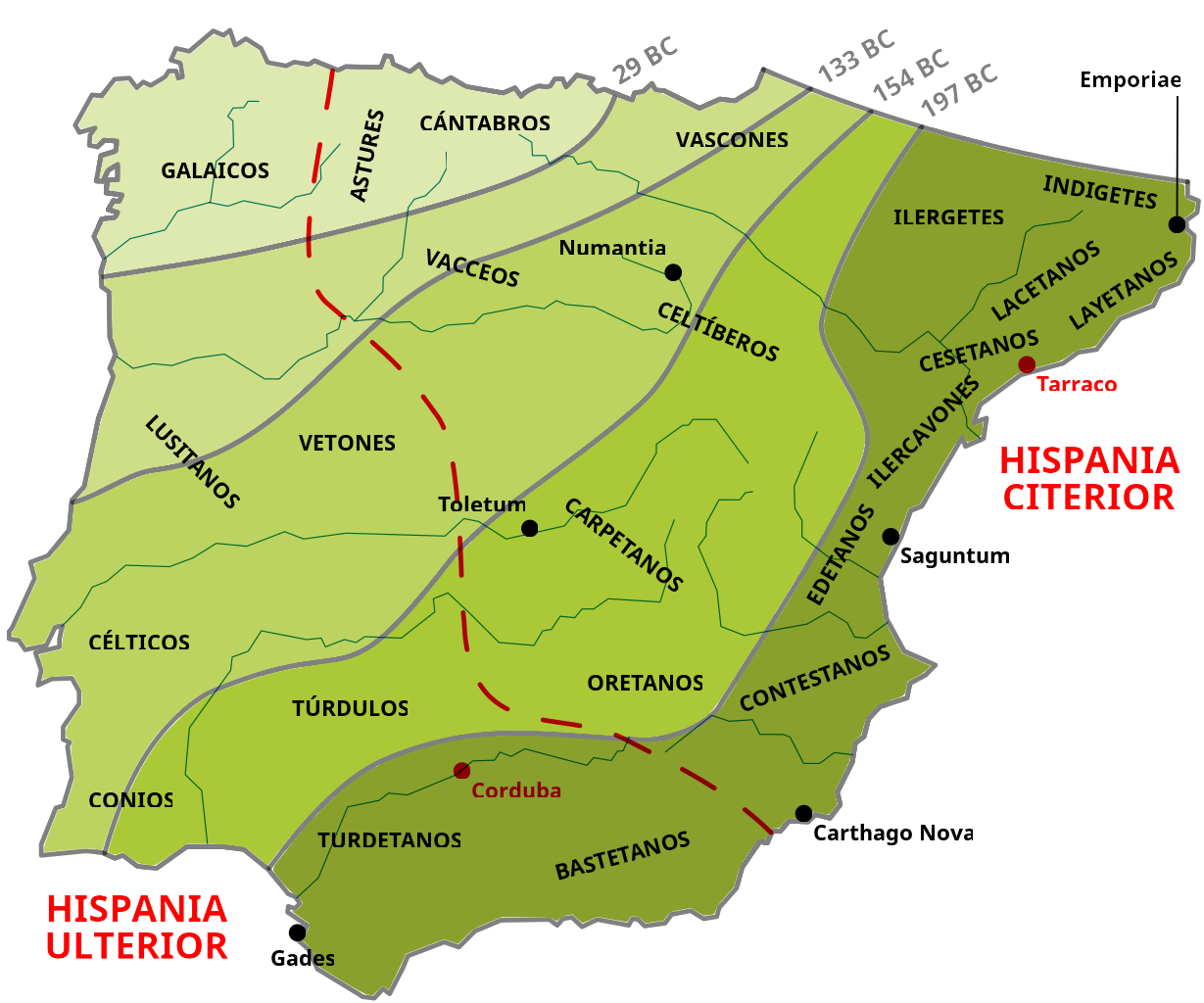
English: Map of the Roman conquest of Hispania, from the beginning of the Second Punic War (218 BC) until the beginning of the Cantabrian Wars (29 BC). It contains simplified territorial conquests, the original division between the provinces of Hispania Citerior and Hispania Ulterior and location of the main pre-Roman peoples.
Español: Mapa de la conquista romana de Hispania, desde el inicio de la Segunda Guerra Púnica (218 a. C.) hasta el inicio de las Guerras Cántabras (29 a. C.). Recoge de forma orientativa y simplificada los avances territoriales y la primitiva división provincial entre Hispania Citerior e Hispania Ulterior, así como la localización de los principales pueblos prerromanos.
Português: Mapa da conquista romana da Hispânia, desde o início da Segunda Guerra Púnica (218 a. C.) até o início das Guerras Cantábricas (29 a. C.). Apresenta de forma aproximada e simplificada os avanços territoriais e a divisão original das províncias da Hispânia Citerior e Hispânia Ulterior com a localização dos principais povos pré-romanos. |
| Date | |
| Source |
English: This map is my own work (made with Inkscape), although the information is based on several sources:
Español: El mapa es de elaboración propia (hecho con Inkscape), aunque la información que contiene está basada en varias fuentes:
Português: O mapa é de elaboração própria (feito com Inkscape), embora as informações que contém são baseadas em várias fontes:
|
| Author | SaxumLeft |
| SVG development |
Licensing[edit]
I, the copyright holder of this work, hereby publish it under the following license:
This file is licensed under the Creative Commons Attribution-Share Alike 3.0 Unported license.
- You are free:
- to share – to copy, distribute and transmit the work
- to remix – to adapt the work
- Under the following conditions:
- attribution – You must give appropriate credit, provide a link to the license, and indicate if changes were made. You may do so in any reasonable manner, but not in any way that suggests the licensor endorses you or your use.
- share alike – If you remix, transform, or build upon the material, you must distribute your contributions under the same or compatible license as the original.
File history
Click on a date/time to view the file as it appeared at that time.
| Date/Time | Thumbnail | Dimensions | User | Comment | |
|---|---|---|---|---|---|
| current | 22:26, 14 February 2023 | | 2,065 × 1,720 (77 KB) | SaxumLeft (talk | contribs) | Incorporación de las dos capitales provinciales (Tarraco y Corduba), latinización de topónimos, sutitución del río Mijares por el Turia (de mayor entidad) y aplicación de tipografía Noto Sans |
| 10:40, 16 February 2019 |  | 2,065 × 1,720 (78 KB) | SaxumLeft (talk | contribs) | Corrección del color de los ríos y nuevo centrado del mapa y recorte del área de imagen tras las últimas correcciones. | |
| 10:02, 16 February 2019 |  | 2,101 × 1,708 (76 KB) | SaxumLeft (talk | contribs) | Eliminación de transparencias en los colores, para seguir mejorando la compatibilidad. | |
| 09:17, 16 February 2019 |  | 2,101 × 1,708 (61 KB) | SaxumLeft (talk | contribs) | Reverted to version as of 09:09, 16 February 2019 (UTC) | |
| 09:14, 16 February 2019 |  | 2,081 × 1,698 (69 KB) | SaxumLeft (talk | contribs) | Reverted to version as of 21:38, 14 February 2019 (UTC) | |
| 09:09, 16 February 2019 |  | 2,101 × 1,708 (61 KB) | SaxumLeft (talk | contribs) | Conversión de "Inkscape SVG" a "Plain SVG", para resolver problemas de compatibilidad. | |
| 21:38, 14 February 2019 |  | 2,081 × 1,698 (69 KB) | SaxumLeft (talk | contribs) | He corregido la ubicación de diversos pueblos y las líneas de delimitación de las fases de la conquista y de las provincias romanas de la Citerior y la Ulterior, de acuerdo con las informaciones contenidas en el libro de G. Bravo, cuya referencia he añadido al apartado de las fuentes. También he añadido algunos ríos que son relevantes a la hora de delimitar los espacios ocupados por dichos pueblos. | |
| 09:22, 5 August 2011 |  | 2,101 × 1,708 (59 KB) | SaxumLeft (talk | contribs) | Centrado del mapa y recorte del área de imagen. | |
| 09:17, 5 August 2011 |  | 2,299 × 1,708 (59 KB) | SaxumLeft (talk | contribs) | He cambiado el color de las líneas del perímetro peninsular y de los avances territoriales, para que se vean mejor los nombres de ciudades y de pueblos prerromanos, y he variado ligeramente la colocación de algunas etiquetas, para hacer el mapa más co | |
| 22:26, 3 August 2011 |  | 2,299 × 1,708 (59 KB) | SaxumLeft (talk | contribs) |
You cannot overwrite this file.
File usage on Commons
The following 3 pages use this file:
File usage on other wikis
The following other wikis use this file:
- Usage on en.wikipedia.org
- Usage on es.wikipedia.org
- Usage on es.wikibooks.org
- Usage on eu.wikipedia.org
- Usage on la.wikipedia.org
- Usage on pt.wikipedia.org
- Usage on sl.wikipedia.org
- Usage on uk.wikipedia.org