File:Concentración de NO2 durante los Incendios en Corrientes de 2022 CONAE.jpg
Concentración_de_NO2_durante_los_Incendios_en_Corrientes_de_2022_CONAE.jpg (800 × 585 pixels, file size: 121 KB, MIME type: image/jpeg)
Captions
Captions
Summary
[edit]
| Description |
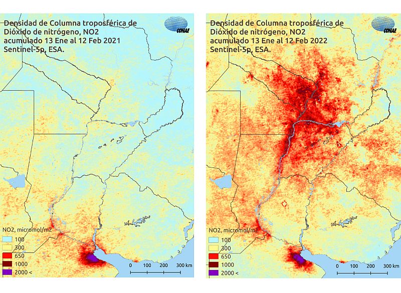
Español: Evolución de la concentración de NO2 durante los incendios en Corrientes de 2022. En el caso del NO2, la densidad de columna troposférica acumulada sobre el territorio afectado fue de 1000 micromol/m2 entre el 13 de enero y el 12 de febrero de 2022, en comparación de los valores de entre 100 y 300 obtenidos un año atrás.
English: Evolution of NO2 concentration during the wildfires that affected the Corrientes province in 2022. |
| Date | |
| Source | https://www.argentina.gob.ar/noticias/informacion-satelital-sobre-los-incendios-en-corrientes |
| Author | CONAE |
Licensing
[edit]

|
This image contains data from a satellite in the Copernicus Programme, such as Sentinel-1, Sentinel-2 or Sentinel-3. Attribution is required when using this image.
Attribution: Contains modified Copernicus Sentinel data 2022
The use of Copernicus Sentinel Data is regulated under EU law (Commission Delegated Regulation (EU) No 1159/2013 and Regulation (EU) No 377/2014). Relevant excerpts:
Free access shall be given to GMES dedicated data [...] made available through GMES dissemination platforms [...].
Access to GMES dedicated data [...] shall be given for the purpose of the following use in so far as it is lawful:
GMES dedicated data [...] may be used worldwide without limitations in time.
GMES dedicated data and GMES service information are provided to users without any express or implied warranty, including as regards quality and suitability for any purpose. |
- You are free:
- to share – to copy, distribute and transmit the work
- to remix – to adapt the work
- Under the following conditions:
- attribution – You must give appropriate credit, provide a link to the license, and indicate if changes were made. You may do so in any reasonable manner, but not in any way that suggests the licensor endorses you or your use.
File history
Click on a date/time to view the file as it appeared at that time.
| Date/Time | Thumbnail | Dimensions | User | Comment | |
|---|---|---|---|---|---|
| current | 01:19, 25 February 2022 | | 800 × 585 (121 KB) | BugWarp (talk | contribs) | Uploaded a work by CONAE from https://www.argentina.gob.ar/noticias/informacion-satelital-sobre-los-incendios-en-corrientes with UploadWizard |
You cannot overwrite this file.
File usage on Commons
There are no pages that use this file.