File:Composite world atlas, by William Faden (14383004).jpg
Jump to navigation
Jump to search

Size of this preview: 422 × 600 pixels. Other resolutions: 169 × 240 pixels | 338 × 480 pixels | 540 × 768 pixels | 720 × 1,024 pixels | 1,441 × 2,048 pixels | 4,989 × 7,090 pixels.
Original file (4,989 × 7,090 pixels, file size: 9.14 MB, MIME type: image/jpeg)
Captions
Captions
Add a one-line explanation of what this file represents
Summary[edit]
.jpg&action=edit§ion=1)
| Description |
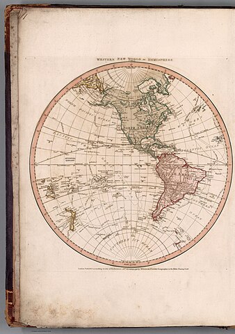
English: Composite World Atlas, by William Faden (1749-1836), published in London, 1794. Bound in pebbled brown board with abraded leather corners and spine. With gilt spine title. Bound in 19th century half red calf over purple pebble-grain cloth, with gilt spine title. Pink end papers. Bookplate: Liverpool Library, Lyceum, Bold Street. Stamp for the “Liverpool Library” on many of the maps within. Elephant folio. Collation: 2° : [1], 48 leaves of plates. With a contemporary manuscript index listing forty-eight subjects in order of appearance, including the wall-maps of the Mediterranean, Asia, India, Africa and the Americas, each joined in two sections and listed as two subjects. Geographic coverage spans the globe, including maps of the Western, Eastern, Northern and Southern Hemispheres, as well as Europe, the United States and the West Indies. Maps show political boundaries, cities, roads, canals, topography, deserts, bodies of water, drainage, coastlines, islands, water depths and anchorage. Maps feature routes of European exploration, such as the voyages of Captain Cook. Maps include decorative cartouches and descriptive text, including notes on voyages. Engravings with original hand-coloring.
Français : Atlas mondial composite, par William Faden (1749-1836), publié à Londres, 1794. Reliure en carton brun grainé avec coins et dos en cuir abrasé. Avec titre doré au dos. Relié en demi-veau rouge du XIXe siècle sur toile grain grain violet, avec titre doré au dos. Gardes roses. Ex-libris : Liverpool Library, Lyceum, Bold Street. Sceau de la "Bibliothèque de Liverpool" sur de nombreuses cartes à l'intérieur. Folio éléphant. Collation : 2° : [1], 48 feuillets de planches. Avec un index manuscrit contemporain répertoriant quarante-huit sujets par ordre d'apparition, y compris les cartes murales de la Méditerranée, de l'Asie, de l'Inde, de l'Afrique et des Amériques, chacune réunie en deux sections et répertoriée comme deux sujets. La couverture géographique couvre le monde entier, y compris les cartes des hémisphères ouest, est, nord et sud, ainsi que l'Europe, les États-Unis et les Antilles. Les cartes montrent les frontières politiques, les villes, les routes, les canaux, la topographie, les déserts, les plans d'eau, le drainage, les côtes, les îles, les profondeurs de l'eau et l'ancrage. Les cartes présentent des itinéraires d'exploration européenne, tels que les voyages du capitaine Cook. Les cartes comprennent des cartouches décoratifs et un texte descriptif, y compris des notes sur les voyages. Gravures avec colorisation originale à la main. |
||||||||||||||||||||||
| Date | |||||||||||||||||||||||
| Source | list, main | ||||||||||||||||||||||
| Author |
|
||||||||||||||||||||||
Licensing[edit]
.jpg&action=edit§ion=2)
|
This is a faithful photographic reproduction of a two-dimensional, public domain work of art. The work of art itself is in the public domain for the following reason:
The official position taken by the Wikimedia Foundation is that "faithful reproductions of two-dimensional public domain works of art are public domain".
This photographic reproduction is therefore also considered to be in the public domain in the United States. In other jurisdictions, re-use of this content may be restricted; see Reuse of PD-Art photographs for details. | ||||
File history
Click on a date/time to view the file as it appeared at that time.
| Date/Time | Thumbnail | Dimensions | User | Comment | |
|---|---|---|---|---|---|
| current | 09:30, 23 July 2023 | | 4,989 × 7,090 (9.14 MB) | YannBot (talk | contribs) | == {{int:filedesc}} == {{Information |Description={{en|1=''Composite World Atlas'', by William Faden (1749-1836), published in London, 1794. Bound in pebbled brown board with abraded leather corners and spine. With gilt spine title. Bound in 19th century half red calf over purple pebble-grain cloth, with gilt spine title. Pink end papers. Bookplate: Liverpool Library, Lyceum, Bold Street. Stamp for the “Liverpool Library” on many of the maps within. Elephant folio. Collation: 2° : [1], 48 lea... |
You cannot overwrite this file.
File usage on Commons
There are no pages that use this file.
.jpg&oldid=866798234)