File:Communauté d'agglomération du Boulonnais.jpg
Original file (4,032 × 3,024 pixels, file size: 3.3 MB, MIME type: image/jpeg)
Captions
Summary[edit]
DescriptionCommunauté d'agglomération du Boulonnais.jpg |
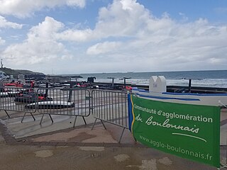
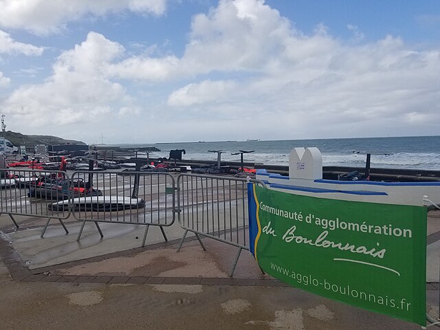
Français : Bannière de la CAB lors d'une régate près de Boulogne (2024) |
Date | |
Source | Own work |
Author | GloriaTengault4 |
Licensing[edit]
- You are free:
- to share – to copy, distribute and transmit the work
- to remix – to adapt the work
- Under the following conditions:
- attribution – You must give appropriate credit, provide a link to the license, and indicate if changes were made. You may do so in any reasonable manner, but not in any way that suggests the licensor endorses you or your use.
File history
Click on a date/time to view the file as it appeared at that time.
Date/Time | Thumbnail | Dimensions | User | Comment | |
---|---|---|---|---|---|
current | 13:38, 22 April 2024 | 4,032 × 3,024 (3.3 MB) | GloriaTengault4 (talk | contribs) | Uploaded own work with UploadWizard |
You cannot overwrite this file.
File usage on Commons
The following page uses this file:
File usage on other wikis
The following other wikis use this file:
- Usage on fr.wikipedia.org
Metadata
This file contains additional information such as Exif metadata which may have been added by the digital camera, scanner, or software program used to create or digitize it. If the file has been modified from its original state, some details such as the timestamp may not fully reflect those of the original file. The timestamp is only as accurate as the clock in the camera, and it may be completely wrong.
Camera manufacturer | samsung |
---|---|
Camera model | SM-G950U |
Exposure time | 1/3,264 sec (0.00030637254901961) |
F-number | f/1.7 |
ISO speed rating | 50 |
Date and time of data generation | 12:21, 21 April 2024 |
Lens focal length | 4.25 mm |
User comments | JKJK0
ŒŽþõ^Û³ êJá £¢ºähÿÿþÜÿÿ ÆÿÿÆš¨ÿÿ¬šÿÿºÝ"""ˆ"ˆˆ""ˆˆˆˆˆˆ""ˆˆˆˆˆ""""ˆˆˆˆˆ"ˆ"""ˆˆ""""""""ˆˆˆ"""""""""""""""""""ˆ"""""""""""""""""""""""""""""""""""""""""""‘"""""""""""""‘‘‘""‘‘"‘""""""‘‘‘"‘‘"""""""‘‘‘‘‘‘""w"w"w"w"w"w‘‘‘‘‘‘‘‘‘""w"w"w"w"w"w‘‘‘‘‘‘‘‘‘‘"w"w"w"w"w"w‘‘‘‘‘‘‘‘‘‘"w"w"w"w"w"w‘‘‘‘‘‘‘‘‘‘‘"w"w"w"w"w‘‘‘‘‘‘‘‘‘‘‘‘‘‘"w"w?ÿ'!+&. êX ý÷F ýF ýF ý˜ ý˜ ý˜ ýâsV¶€|€€©# %!)%!)÷FÐ ° Ó€”’FAFA¡?q¡¡3FAFAúÿ±ÿ@vç“ŽŽúÿ±ÿ@vç“úÿ±ÿ@v磎üÿ#vç£ûÿ<òÿvçãŽûÿ<òÿvçÃŽ úÐ ðøÐØFAFAŠbŽç“çj”¨ l ŽQ’ç‘çʇ›WŒq–ç”çç’çç‘ÔŽçˆû„–Å•ÀŒ?’ç—žçç‡Eˆç†.‹Áˆ?‰+’¨‰V˜,–çŒçç‹r‹‹'¢ˆç‡vˆ„‹}ˆV¦”ç’ç‘ç‹ç‹ççŽçŽç‹ççççç”ç“ç‘çŽçŒççççç’眑ےç–çççŒçŒçŒçç‘ç”ç•ç–ç”çM”é•1‘]’F?Œ ç”ç•ç™Ê™çšl‡‘“•‘•™’––ç’ç‘ç Žçÿ®®®®‡ 1¡r_ ! EE†[ _ ¼ 2À îîîîi1/! !Žùÿÿÿás¾ ¢ u m ‘ x u o | t | ` P G 4 " Ø "T£— R _ k V TCMJ-n¼äØ߬{wAkð~¡›b]68ú(ÊÿÊRîÿÿÿƒ _ £ @EUÿÿÿ?"LÚÿÿÿn$ `,9çÿÿÿ íÿÿÿÌÿÿÿ—ÿÿÿÀÿÿÿÀÿÿÿ—ÿÿÿëÿÿÿãÿÿÿÖKF¼?¾ êÿÿÿëÿÿÿ] L¼ ER`rd/–-Îssdjagssuniqueidk`3=†#W3ssmtf¡øúôïÈÈÈÈÈÈÈÈÈÈÈÈÈȪªªªªªªªªªªªªªxxxtxxxxSSCAL PF12QSKC0222401FFC1FC1S12ssoisD84KA02 D84KA02 D84KA02 0 |
Latitude | 0° 0′ 0″ N |
Longitude | 0° 0′ 0″ E |
Altitude | 0 meters above sea level |
Width | 4,032 px |
Height | 3,024 px |
Orientation | Normal |
Horizontal resolution | 72 dpi |
Vertical resolution | 72 dpi |
Software used | G950USQU6DSG7 |
File change date and time | 12:21, 21 April 2024 |
Y and C positioning | Centered |
Exposure Program | Normal program |
Exif version | 2.2 |
Date and time of digitizing | 12:21, 21 April 2024 |
Meaning of each component |
|
APEX shutter speed | 11.672 |
APEX aperture | 1.53 |
APEX brightness | 9.01 |
APEX exposure bias | 0 |
Maximum land aperture | 1.53 APEX (f/1.7) |
Metering mode | Center weighted average |
Light source | Unknown |
Flash | Flash did not fire |
Supported Flashpix version | 1 |
Color space | sRGB |
Sensing method | One-chip color area sensor |
Scene type | A directly photographed image |
Exposure mode | Auto exposure |
White balance | Auto white balance |
Focal length in 35 mm film | 26 mm |
Scene capture type | Standard |
Unique image ID | F12QSJA00SM F12QSKB01SB |
GPS time (atomic clock) | 10:21 |
GPS date | 21 April 2024 |
GPS tag version | 0.0.2.2 |