File:Cobblers Pits - A Yew Woodland in Disused Quarries - geograph.org.uk - 1310392.jpg
Cobblers_Pits_-_A_Yew_Woodland_in_Disused_Quarries_-_geograph.org.uk_-_1310392.jpg (640 × 480 pixels, file size: 263 KB, MIME type: image/jpeg)
Captions
Captions
Summary
[edit]
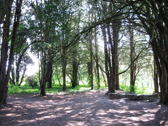
| Description |
English: Cobblers Pits A Yew Woodland in Disused Quarries From the Information Board
Pure stands of yew are unusual but serve well as a screen for a redundant quarry. Commonly planted around country houses in the 18th and 19th centuries, are they the work of Lord Lake, owner of the pre-Rothschild Aston Clinton Manor. Whatever their origin, the tree are now being managed by Buckinghamshire County Council to replace the recent storm damage [probably referring to 1987] and ensure their long-term well being. Light and Dark .... Walking along the sunken lane the gloom of the closed canopy, familiar to travellers of old, is suddenly broken by a flood of light where the ageing trees on the pits' thin soils have been torn down by recent storms. The light brings with it opportunity and abundance as the sparse undergrowth of shade tolerant ivy under the yews is swamped by a multitude of light loving grasses, herbs and shrubs, taking advantage of the newly created open space. As the current tree planting grows up, and shade returns, the ivy will re-establish itself whilst the invaders await the next storm. This view shows the stand of yews at the north end of a long narrow strip of woodland, with evidence of quarrying. There is another significant stand at the south end and an area with young yew trees whose size fits in with replanting after 1987. However my first impression is that there were parts of the wood which were never mainly yew. |
| Date | |
| Source | From geograph.org.uk |
| Author | Chris Reynolds |
| Attribution (required by the license) | Chris Reynolds / Cobblers Pits – A Yew Woodland in Disused Quarries / |
| Camera location | | View this and other nearby images on: OpenStreetMap |
|---|
_heading:135.00&language=en)
| Object location | | View this and other nearby images on: OpenStreetMap |
|---|
_heading:135.00&language=en)
Licensing
[edit]

|
This image was taken from the Geograph project collection. See this photograph's page on the Geograph website for the photographer's contact details. The copyright on this image is owned by Chris Reynolds and is licensed for reuse under the Creative Commons Attribution-ShareAlike 2.0 license.
|
- You are free:
- to share – to copy, distribute and transmit the work
- to remix – to adapt the work
- Under the following conditions:
- attribution – You must give appropriate credit, provide a link to the license, and indicate if changes were made. You may do so in any reasonable manner, but not in any way that suggests the licensor endorses you or your use.
- share alike – If you remix, transform, or build upon the material, you must distribute your contributions under the same or compatible license as the original.
File history
Click on a date/time to view the file as it appeared at that time.
| Date/Time | Thumbnail | Dimensions | User | Comment | |
|---|---|---|---|---|---|
| current | 16:25, 27 February 2011 | | 640 × 480 (263 KB) | GeographBot (talk | contribs) | == {{int:filedesc}} == {{Information |description={{en|1=Cobblers Pits A Yew Woodland in Disused Quarries From the Information Board Pure stands of yew are unusual but serve well as a screen for a redundant quarry. Commonly planted around country ho |
You cannot overwrite this file.
File usage on Commons
The following page uses this file: