File:Coast of Cuba from Cape of San Antonio to the Bay of Cardenas WDL77.png
Jump to navigation
Jump to search

Size of this preview: 800 × 268 pixels. Other resolutions: 320 × 107 pixels | 640 × 215 pixels | 1,024 × 343 pixels | 1,280 × 429 pixels | 3,054 × 1,024 pixels.
Original file (3,054 × 1,024 pixels, file size: 4.87 MB, MIME type: image/png)
Captions
Captions
Add a one-line explanation of what this file represents
Summary
[edit]
| Title |
Русский: Побережье Кубы от мыса Сан-Антонио до залива Карденас
Français : Côte de Cuba, du Cap de San Antonio à la baie de Cardenas
English: Coast of Cuba from Cape of San Antonio to the Bay of Cardenas
中文:从圣安东尼奥角到卡德纳斯湾的古巴海岸
Português: Costa de Cuba do Cabo de Santo Antônio até a Baía de Cardenas
العربية: ساحل كوبا من رأس سان انطونيو إلى خليج كارديناس
Español: Costa de Cuba desde Cabo de San Antonio hasta la Bahía de Cárdenas |
| Description |
Русский: На данной испанской карте части северного побережья Кубы изображены береговая линия, береговые ориентиры, отметки глубины, потенциальные опасности для навигации, крепость и поселения. В нее также включена красиво украшенная роза ветров и пять видов берегового профиля. Карта ориентирована на юг. Эта карта первоначально принадлежала реальному мореходному училищу (Real Escuela de Navegación) в Кадизе, Испания, и была приобретена для коллекции Библиотеки Конгресса у лондонской фирмы "Мэггз Брадерз".
Français : Cette carte espagnole d'une partie de la côte nord de Cuba montre le tracé et les caractéristiques de la côte, les sondages, les dangers de la navigation, une fortification et les colonies de peuplement. Elle comprend une rose des vents décorative et cinq vues latérales de la côte. Le sud est situé en haut. Cette carte provient de la Real Escuela de Navegación de Cadix, en Espagne. La Bibliothèque du Congrès se la procura chez Maggs Brothers, à Londres.
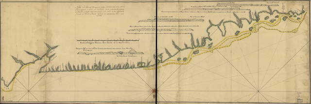
English: This Spanish map of a portion of the north coast of Cuba shows the coastline, coastal features, soundings, navigational hazards, a fortification, and settlements. It includes a decorative wind rose and five coastal profile views. The map is oriented with south at the top. It is from the Real Escuela de Navegación in Cadiz, Spain, and was acquired by the Library of Congress from the Maggs Brothers, London.
中文:这幅西班牙地图描绘的是古巴的部分北海岸,显示了这里的海岸线、沿海特征、水深、航海危险、一处防御工事和定居点。 地图上还包括一个装饰的风花图和五个海岸轮廓视图。 该地图以上方向为南。 该地图源自西班牙加的斯的 Real Escuela de Navegación,由美国国会图书馆从伦敦马格斯兄弟处购得。
Português: Este mapa espanhol de uma região da costa setentrional de Cuba mostra o litoral, aspectos costeiros, estreitos, perigos para a navegação, uma fortificação e colônias. Inclui uma rosa dos ventos ornamental e cinco imagens de aspectos costeiros. O mapa está orientado com o sul na parte superior. É da Real Escuela de Navegación em Cadiz, Espanha, e foi adquirido de Maggs Brothers, em Londres, pela Biblioteca do Congresso.
العربية: تظهر هذه الخريطة الأسبانية لجزء من الساحل الشمالي لكوبا الخط الساحلية والملامح الساحلية وقياسات العمق البحري والأخطار الملاحية وحصن والمستوطنات.
كما تشمل أيضا رسما مزخرفا لوردة الريح بالإضافة إلى خمسة مشاهد جانبية للسواحل.ويظهر الاتجاه الجنوبي في أعلى الخريطة. وهي من ريال إسكويلا دي نافيغاسيون في كاديز في اسبانيا، وقد اقتنتها مكتبة الكونغرس من الإخوان ماغز في لندن. Español: Este mapa español de parte de la costa norte de Cuba muestra la ribera, los accidentes costeros, los sondeos, los obstáculos navegacionales, una fortificación y asentamientos. Incluye una rosa de los vientos decorativa y cinco vistas del perfil costero. El mapa está orientado con el sur en la parte superior. Proviene de la Real Escuela de Navegación de Cádiz, España, y fue comprado por la Biblioteca del Congreso a la compañía londinense Maggs Brothers. |
| Date | 1780 |
| Medium |
Русский: Карты
Français : Cartes
English: Maps
中文:地图
Português: Mapas
العربية: خرائط
Español: Mapas |
| Dimensions |
English: 1 manuscript map : color ; 49 x 149 centimeters |
| Collection |
Русский: Библиотека Конгресса
Français : Bibliothèque du Congrès
English: Library of Congress
中文:国会图书馆
Português: Biblioteca do Congresso
العربية: مكتبة الكونغرس
Español: Biblioteca del Congreso |
| Place of creation |
Русский: Куба
Français : Cuba
English: Cuba
中文:古巴
Português: Cuba
العربية: كوبا
Español: Cuba |
| Notes | Original language title: Costa de Cuba desde Cabo de San Antonio a la bahía de Cardenas |
| References | http://hdl.loc.gov/loc.wdl/dlc.77 |
| Source/Photographer |
|
Licensing
[edit]
|
This is a faithful photographic reproduction of a two-dimensional, public domain work of art. The work of art itself is in the public domain for the following reason:
The official position taken by the Wikimedia Foundation is that "faithful reproductions of two-dimensional public domain works of art are public domain".
This photographic reproduction is therefore also considered to be in the public domain in the United States. In other jurisdictions, re-use of this content may be restricted; see Reuse of PD-Art photographs for details. | ||||
File history
Click on a date/time to view the file as it appeared at that time.
| Date/Time | Thumbnail | Dimensions | User | Comment | |
|---|---|---|---|---|---|
| current | 23:24, 11 March 2014 | 3,054 × 1,024 (4.87 MB) | Fæ (talk | contribs) | =={{int:filedesc}}== {{Artwork |artist = |author = |title ={{ru|1=Побережье Кубы от мыса Сан-Антонио до залива Карденас}} {{fr|1=Côte de Cuba, du Cap de San Antonio à la baie de Cardenas}} {{en|1=Coast of... |
You cannot overwrite this file.
File usage on Commons
The following page uses this file: