File:Claremont square, Islington (4) - geograph.org.uk - 1523975.jpg
Claremont_square,_Islington_(4)_-_geograph.org.uk_-_1523975.jpg (640 × 433 pixels, file size: 120 KB, MIME type: image/jpeg)
Captions
Captions
Summary[edit]
_-_geograph.org.uk_-_1523975.jpg&action=edit§ion=1)
| Description |
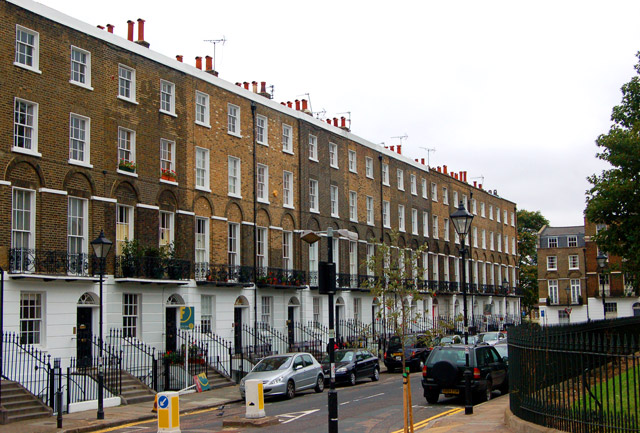
English: Claremont square, Islington (4) Looking southwest at the south side of Claremont Square, Islington. The square was developed in the 1820s around the Upper Pond of the New River Company.
The New River is a man-made water channel which carried drinking water for 20 miles to London from the River Lee and Amwell Springs in Hertfordshire. It opened in 1613 and fed reservoirs in Islington. One of these, known as the Upper Pond, was built in 1709 beside Pentonville Road. The reservoir in Claremont Square was covered and turfed in 1852 when open areas of standing water in London were prohibited by law. The reservoir is still in use by Thames Water. The semi-improved grassland on the top and sides of the reservoir supports a wide diversity of wild flowers and is a preserved habitat with restricted access. In this photo, the bank of the reservoir is just visible on the right of the picture. See also [1] and [2] . |
| Date | |
| Source | From geograph.org.uk |
| Author | Andy F |
| Attribution (required by the license) | Andy F / Claremont square, Islington (4) / |
| Camera location | | View this and other nearby images on: OpenStreetMap |
|---|
_-_geograph.org.uk_-_1523975.jpg¶ms=051.531240_N_-000.109000_E_globe:Earth_type:camera_source:geograph-osgb36(TQ31268306)_heading:225.00&language=en)
| Object location | | View this and other nearby images on: OpenStreetMap |
|---|
_-_geograph.org.uk_-_1523975.jpg¶ms=051.531070_N_-000.109600_E_globe:Earth_class:object_type:object_source:geograph-osgb36(TQ31228304)_heading:225.00&language=en)
Licensing[edit]
_-_geograph.org.uk_-_1523975.jpg&action=edit§ion=2)

|
This image was taken from the Geograph project collection. See this photograph's page on the Geograph website for the photographer's contact details. The copyright on this image is owned by Andy F and is licensed for reuse under the Creative Commons Attribution-ShareAlike 2.0 license.
|
- You are free:
- to share – to copy, distribute and transmit the work
- to remix – to adapt the work
- Under the following conditions:
- attribution – You must give appropriate credit, provide a link to the license, and indicate if changes were made. You may do so in any reasonable manner, but not in any way that suggests the licensor endorses you or your use.
- share alike – If you remix, transform, or build upon the material, you must distribute your contributions under the same or compatible license as the original.
File history
Click on a date/time to view the file as it appeared at that time.
| Date/Time | Thumbnail | Dimensions | User | Comment | |
|---|---|---|---|---|---|
| current | 02:53, 3 March 2011 | | 640 × 433 (120 KB) | GeographBot (talk | contribs) | == {{int:filedesc}} == {{Information |description={{en|1=Claremont square, Islington (4) Looking southwest at the south side of Claremont Square, Islington. The square was developed in the 1820s around the Upper Pond of the New River Company. The New R |
You cannot overwrite this file.
File usage on Commons
The following 3 pages use this file:
File usage on other wikis
The following other wikis use this file:
- Usage on ar.wikipedia.org
- Usage on arz.wikipedia.org
- Usage on de.wikipedia.org
- Usage on fr.wikipedia.org
- Usage on ja.wikipedia.org
- Usage on pl.wikipedia.org
- Usage on www.wikidata.org
_-_geograph.org.uk_-_1523975.jpg&oldid=861686387)