File:Cilician Armenia-cs.svg
Jump to navigation
Jump to search

Size of this PNG preview of this SVG file: 800 × 571 pixels. Other resolutions: 320 × 228 pixels | 640 × 457 pixels | 1,024 × 730 pixels | 1,280 × 913 pixels | 2,560 × 1,826 pixels | 2,508 × 1,789 pixels.
Original file (SVG file, nominally 2,508 × 1,789 pixels, file size: 654 KB)
Captions
Captions
Add a one-line explanation of what this file represents
Summary[edit]
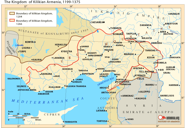
| Description |
Čeština: Česká mapa Arménského království v Kilíkii během 13. století
English: Czech Map of the Armenian Kingdom of Cilicia during the XIII century.
Français : Carte tchèque du royaume de Petite Arménie (en Cilicie) au XIIIe siècle.
Italiano: Cartina in ceco del Regno armeno di Cilicia nel XIII secolo. |
| Date | |
| Source |
Travail personnel.
Sources :
Logiciels utilisés :
Autres données :
|
| Author | Sémhur translated by Jklamo |
| Other versions |
[]
|


I, the copyright holder of this work, hereby publish it under the following licenses:

|
Permission is granted to copy, distribute and/or modify this document under the terms of the GNU Free Documentation License, Version 1.2 or any later version published by the Free Software Foundation; with no Invariant Sections, no Front-Cover Texts, and no Back-Cover Texts. A copy of the license is included in the section entitled GNU Free Documentation License. |
This file is licensed under the Creative Commons Attribution-Share Alike 3.0 Unported, 2.5 Generic, 2.0 Generic and 1.0 Generic license.
- You are free:
- to share – to copy, distribute and transmit the work
- to remix – to adapt the work
- Under the following conditions:
- attribution – You must give appropriate credit, provide a link to the license, and indicate if changes were made. You may do so in any reasonable manner, but not in any way that suggests the licensor endorses you or your use.
- share alike – If you remix, transform, or build upon the material, you must distribute your contributions under the same or compatible license as the original.
You may select the license of your choice.

|
This SVG file contains embedded text that can be translated into your language, using any capable SVG editor, text editor or the SVG Translate tool. For more information see: About translating SVG files. |
This W3C-unspecified vector image was created with Inkscape .
File history
Click on a date/time to view the file as it appeared at that time.
| Date/Time | Thumbnail | Dimensions | User | Comment | |
|---|---|---|---|---|---|
| current | 23:53, 2 March 2009 | | 2,508 × 1,789 (654 KB) | Jklamo (talk | contribs) | Minor tweaks |
| 23:41, 2 March 2009 |  | 2,508 × 1,789 (665 KB) | Jklamo (talk | contribs) | == Description == {{Information |Description= {{cs| Česká mapa Arménského království v Kilíkii během 13. století}} {{en| Italian Map of the Armenian Kingdom of Cilicia |
You cannot overwrite this file.
File usage on Commons
The following 9 pages use this file:
File usage on other wikis
The following other wikis use this file:
- Usage on cs.wikipedia.org
- Usage on sk.wikipedia.org