File:Chesil Beach - geograph.org.uk - 1453371.jpg
Jump to navigation
Jump to search
No higher resolution available.
Chesil_Beach_-_geograph.org.uk_-_1453371.jpg (640 × 440 pixels, file size: 113 KB, MIME type: image/jpeg)
Captions
Captions
Add a one-line explanation of what this file represents
Summary[edit]
| Description |
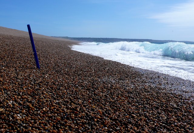
English: Chesil Beach There is virtually none of this square on dry land, only a few square metres at the lowest tides. The blue stick marks the position of the grid line intersection at SY6500077000 as determined by GPS. The view is towards the SE and the Isle of Portland which can be seen in the distance. The photo was taken at the lowest point of the tide at 13.30 on 22 August 2009. This day was chosen as it was the lowest tide in the current tidal cycle and the photographer had to wait for the tide to go out, and even then the land within the square was only revealed when each wave receded. It was covered up again by each wave as can be seen by the other photo of the square. The photographer got very wet even though he had stripped down to his boxer shorts. This was a low tide but not the lowest tide of the year and a few more inches may be revealed at extra low spring tides. Only the land in the foreground is in SY6476 , the land beyond the blue stick being in SY6576
The photographers position was recorded as SY6499876999 by GPS (photo available). No photo of the wet boxer shorts is available. |
| Date | |
| Source | From geograph.org.uk |
| Author | Nigel Mykura |
| Attribution (required by the license) | Nigel Mykura / Chesil Beach / |
| Camera location | | View this and other nearby images on: OpenStreetMap |
|---|
_heading:90.00&language=en)
| Object location | | View this and other nearby images on: OpenStreetMap |
|---|
_heading:90.00&language=en)
Licensing[edit]

|
This image was taken from the Geograph project collection. See this photograph's page on the Geograph website for the photographer's contact details. The copyright on this image is owned by Nigel Mykura and is licensed for reuse under the Creative Commons Attribution-ShareAlike 2.0 license.
|
This file is licensed under the Creative Commons Attribution-Share Alike 2.0 Generic license.
Attribution: Nigel Mykura
- You are free:
- to share – to copy, distribute and transmit the work
- to remix – to adapt the work
- Under the following conditions:
- attribution – You must give appropriate credit, provide a link to the license, and indicate if changes were made. You may do so in any reasonable manner, but not in any way that suggests the licensor endorses you or your use.
- share alike – If you remix, transform, or build upon the material, you must distribute your contributions under the same or compatible license as the original.
File history
Click on a date/time to view the file as it appeared at that time.
| Date/Time | Thumbnail | Dimensions | User | Comment | |
|---|---|---|---|---|---|
| current | 04:52, 2 March 2011 | | 640 × 440 (113 KB) | GeographBot (talk | contribs) | == {{int:filedesc}} == {{Information |description={{en|1=Chesil Beach There is virtually none of this square on dry land, only a few square metres at the lowest tides. The blue stick marks the position of the grid line intersection at SY6500077000 as dete |
You cannot overwrite this file.
File usage on Commons
There are no pages that use this file.