File:Chemin mont Veyrier mont Baron.jpg
Original file (2,616 × 3,512 pixels, file size: 6.78 MB, MIME type: image/jpeg)
Captions
Summary[edit]
DescriptionChemin mont Veyrier mont Baron.jpg |
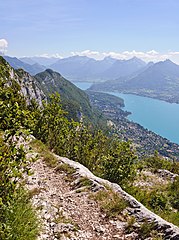
Français : Sur le chemin de crête entre le mont Veyrier et le mont Baron, surplombant Veyriez-du-Lac et le lac d Annecy (Haute-Savoie, France).
English: Trail on the crest between Mont Veyrier and Mont Baron, above Veyriez-du-Lac and Lake Annecy, Haute-Savoie, France. |
Date | |
Source | Own work |
Author | Myrabella |
Attribution (required by the license) InfoField | Photo: Myrabella / Wikimedia Commons / |
InfoField | Photo: Myrabella / Wikimedia Commons |
Camera location | 45° 53′ 59.21″ N, 6° 11′ 00.53″ E | View this and other nearby images on: OpenStreetMap | 45.899780; 6.183480 |
---|
This image has been assessed using the Quality image guidelines and is considered a Quality image.
العربية ∙ جازايرية ∙ беларуская ∙ беларуская (тарашкевіца) ∙ български ∙ বাংলা ∙ català ∙ čeština ∙ Cymraeg ∙ Deutsch ∙ Schweizer Hochdeutsch ∙ Zazaki ∙ Ελληνικά ∙ English ∙ Esperanto ∙ español ∙ eesti ∙ euskara ∙ فارسی ∙ suomi ∙ français ∙ galego ∙ עברית ∙ हिन्दी ∙ hrvatski ∙ magyar ∙ հայերեն ∙ Bahasa Indonesia ∙ italiano ∙ 日本語 ∙ Jawa ∙ ქართული ∙ 한국어 ∙ kurdî ∙ Lëtzebuergesch ∙ lietuvių ∙ македонски ∙ മലയാളം ∙ मराठी ∙ Bahasa Melayu ∙ Nederlands ∙ Norfuk / Pitkern ∙ polski ∙ português ∙ português do Brasil ∙ rumantsch ∙ română ∙ русский ∙ sicilianu ∙ slovenčina ∙ slovenščina ∙ shqip ∙ српски / srpski ∙ svenska ∙ தமிழ் ∙ తెలుగు ∙ ไทย ∙ Tagalog ∙ Türkçe ∙ toki pona ∙ українська ∙ vèneto ∙ Tiếng Việt ∙ 中文 ∙ 中文(简体) ∙ 中文(繁體) ∙ +/− |
Licensing[edit]
- You are free:
- to share – to copy, distribute and transmit the work
- to remix – to adapt the work
- Under the following conditions:
- attribution – You must give appropriate credit, provide a link to the license, and indicate if changes were made. You may do so in any reasonable manner, but not in any way that suggests the licensor endorses you or your use.
- share alike – If you remix, transform, or build upon the material, you must distribute your contributions under the same or compatible license as the original.
Annotations InfoField | This image is annotated: View the annotations at Commons |
Veyrier-du-lac
Menthon-Saint-Bernard
Mont Baret
Roc des Bœufs
Montagne du Charbon
Montagne de Seythenex
Saint-Jorioz
Roc de Chère
File history
Click on a date/time to view the file as it appeared at that time.
Date/Time | Thumbnail | Dimensions | User | Comment | |
---|---|---|---|---|---|
current | 20:30, 13 July 2012 | 2,616 × 3,512 (6.78 MB) | Myrabella (talk | contribs) | == {{int:filedesc}} == {{Information |Description= {{fr|1=Sur le chemin de crête entre le mont Veyrier et le mont Baron, surplombant Veyriez-du-Lac et le lac d Annecy (Haute-Savoie, Fran... |
You cannot overwrite this file.
File usage on Commons
The following 4 pages use this file:
File usage on other wikis
The following other wikis use this file:
- Usage on en.wikipedia.org
- Usage on fr.wikipedia.org
Metadata
This file contains additional information such as Exif metadata which may have been added by the digital camera, scanner, or software program used to create or digitize it. If the file has been modified from its original state, some details such as the timestamp may not fully reflect those of the original file. The timestamp is only as accurate as the clock in the camera, and it may be completely wrong.
Image title |
|
---|---|
Camera manufacturer | NIKON CORPORATION |
Camera model | NIKON D90 |
Exposure time | 1/400 sec (0.0025) |
F-number | f/10 |
ISO speed rating | 200 |
Date and time of data generation | 15:04, 10 August 2011 |
Lens focal length | 18 mm |
Orientation | Normal |
Horizontal resolution | 300 dpi |
Vertical resolution | 300 dpi |
Software used | Adobe Photoshop CS5 Windows |
File change date and time | 22:09, 13 July 2012 |
Exposure Program | Aperture priority |
Exif version | 2.21 |
Date and time of digitizing | 15:04, 10 August 2011 |
APEX shutter speed | 8.643856 |
APEX aperture | 6.643856 |
APEX exposure bias | −0.66666666666667 |
Maximum land aperture | 3.7 APEX (f/3.61) |
Metering mode | Pattern |
Light source | Unknown |
Flash | Flash did not fire |
DateTime subseconds | 00 |
DateTimeOriginal subseconds | 00 |
DateTimeDigitized subseconds | 00 |
Color space | sRGB |
Sensing method | One-chip color area sensor |
File source | Digital still camera |
Scene type | A directly photographed image |
Custom image processing | Normal process |
Exposure mode | Auto exposure |
White balance | Auto white balance |
Digital zoom ratio | 1 |
Focal length in 35 mm film | 27 mm |
Scene capture type | Standard |
Scene control | None |
Contrast | Normal |
Saturation | Normal |
Sharpness | Normal |
Subject distance range | Unknown |
Serial number of camera | 6461655 |
Lens used | 18.0-105.0 mm f/3.5-5.6 |
Rating (out of 5) | 0 |
Date metadata was last modified | 00:09, 14 July 2012 |
Unique ID of original document | F38EA2EB4844F63040BE13B7C8508A10 |
IIM version | 38,970 |
Structured data
Items portrayed in this file
depicts
10 August 2011
45°53'59.21"N, 6°11'0.53"E
0.0025 second
10
18 millimetre
200
image/jpeg
c5274d11c753c3e1e7e2eb9165c8ab5bad6826ad
7,104,591 byte
3,512 pixel
2,616 pixel
- Information field template with formatting
- Files with coordinates missing SDC location of creation
- Quality images
- Quality images missing SDC depicts
- CC-BY-SA-3.0
- Self-published work
- Images with annotations
- Quality images by Myrabella
- Quality images of landscapes
- Quality images of Haute-Savoie
- Quality images of trails
- Pages with maps