File:Chatham-Islands map topo-mk.svg
Jump to navigation
Jump to search

Size of this PNG preview of this SVG file: 702 × 599 pixels. Other resolutions: 281 × 240 pixels | 562 × 480 pixels | 900 × 768 pixels | 1,199 × 1,024 pixels | 2,399 × 2,048 pixels | 1,669 × 1,425 pixels.
Original file (SVG file, nominally 1,669 × 1,425 pixels, file size: 1.3 MB)
Captions
Captions
Add a one-line explanation of what this file represents
Summary
[edit]| Description |
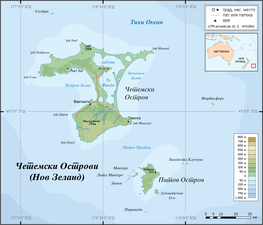
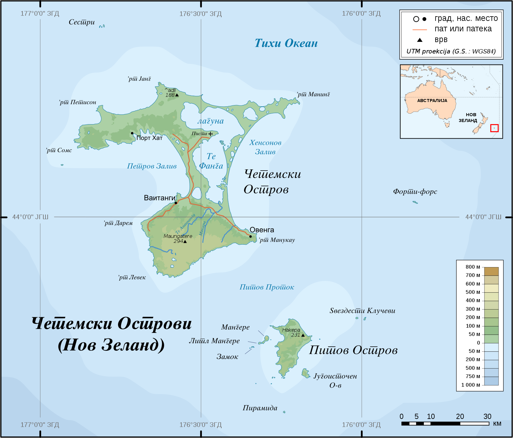
English: Topographic Map of Chatham Islands in Macedonian. The archipelago of the Chatham Islands, consists of about 10 islands within a 40-km radius. The islands have officially belonged to New Zealand since 1842.
Scale ca 1:1.000.000 Македонски: Топографска карта на Четемските Острови на македонски. Овој архипелаг се состои од околу 10 острови во радиус од 40 км. Овие острови официјално му припаѓаат на Нов Зеланд од 1842 г. Размер ~1:1.000.000 |
| Date | |
| Source |
Translated from en:Image:Chatham-Islands map topo en.svg, work of Alexrk
|
| Author | Bojan Jankuloski, based on a work of Alexrk |
| Permission (Reusing this file) |
Creative Commons : share alike - attribution required |
| Other versions |
|


| Camera location | | View this and other nearby images on: OpenStreetMap |
|---|

|
This SVG file contains embedded text that can be translated into your language, using any capable SVG editor, text editor or the SVG Translate tool. For more information see: About translating SVG files. |
Licensing
[edit]
I, the copyright holder of this work, hereby publish it under the following license:
This file is licensed under the Creative Commons Attribution-Share Alike 2.5 Generic license.
- You are free:
- to share – to copy, distribute and transmit the work
- to remix – to adapt the work
- Under the following conditions:
- attribution – You must give appropriate credit, provide a link to the license, and indicate if changes were made. You may do so in any reasonable manner, but not in any way that suggests the licensor endorses you or your use.
- share alike – If you remix, transform, or build upon the material, you must distribute your contributions under the same or compatible license as the original.
File history
Click on a date/time to view the file as it appeared at that time.
| Date/Time | Thumbnail | Dimensions | User | Comment | |
|---|---|---|---|---|---|
| current | 01:57, 6 November 2011 | | 1,669 × 1,425 (1.3 MB) | Bjankuloski06en (talk | contribs) | Improved visibility, legibility, transcription and introducing Macedonian cusrive |
| 10:13, 5 April 2009 |  | 1,669 × 1,425 (814 KB) | Alexrk (talk | contribs) | Grid | |
| 09:19, 26 October 2008 |  | 1,669 × 1,425 (814 KB) | Bjankuloski06en (talk | contribs) | == Summary == {{Information |Description={{en|Topographic Map of '''Chatham Islands''' in Macedonian. The archipelago of the Chatham Islands, consists of about 10 islands within a 40-km radius. The islan |
You cannot overwrite this file.
File usage on Commons
The following 2 pages use this file: