File:Caucasus-ethnic-1995.jpg
Jump to navigation
Jump to search

Size of this preview: 512 × 599 pixels. Other resolutions: 205 × 240 pixels | 410 × 480 pixels | 656 × 768 pixels | 875 × 1,024 pixels | 1,749 × 2,048 pixels | 2,606 × 3,051 pixels.
Original file (2,606 × 3,051 pixels, file size: 2.46 MB, MIME type: image/jpeg)
Captions
Captions
Add a one-line explanation of what this file represents

|
File:Caucasus-ethnic en.svg is a vector version of this file. It should be used in place of this JPG file.
File:Caucasus-ethnic-1995.jpg → File:Caucasus-ethnic en.svg
For more information, see Help:SVG. |
 |

|
This file has been superseded by Caucasus-ethnic-2004.jpg. It is recommended to use the other file. Please note that deleting superseded images requires consent.
|

|
Summary[edit]
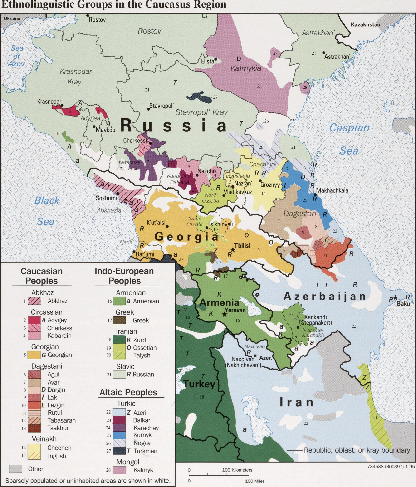
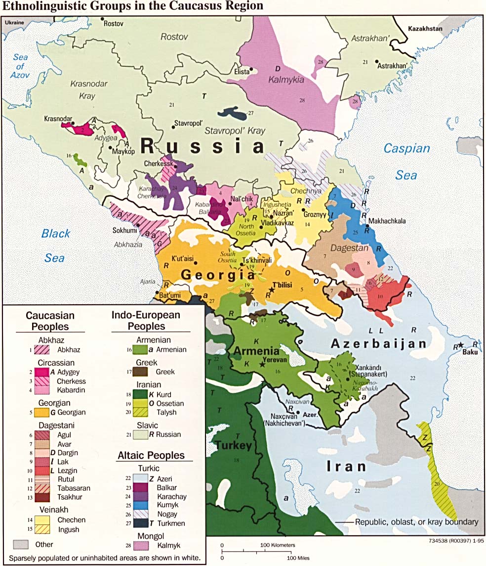
| Description | CIA map on the ethnolinguistic groups in the Caucasus region. National borders are thick black, regional borders within one country in thin black, and disputed borders as dotted lines. |
| Date | |
| Source |
https://www.loc.gov/item/95680196/ (permalink: https://lccn.loc.gov/95680196)
|
| Author | U.S. Central Intelligence Agency |
| Permission (Reusing this file) |
Source states: "The following maps were produced by the U.S. Central Intelligence Agency, unless otherwise indicated." [1] |
| Other versions |
[]
|


Licensing[edit]
| This image is a work of a Central Intelligence Agency employee, taken or made as part of that person's official duties. As a Work of the United States Government, this image or media is in the public domain in the United States.
|

|
File history
Click on a date/time to view the file as it appeared at that time.
| Date/Time | Thumbnail | Dimensions | User | Comment | |
|---|---|---|---|---|---|
| current | 17:49, 29 March 2022 | | 2,606 × 3,051 (2.46 MB) | Cherkash (talk | contribs) | TIFF from the same source (https://www.loc.gov/item/95680196/) - first maximally cropped and then converted to JPG |
| 09:12, 22 March 2022 |  | 2,610 × 3,085 (2.41 MB) | Sette-quattro (talk | contribs) | Higher scan from the same source, from https://www.loc.gov/item/95680196/ | |
| 11:22, 4 July 2017 |  | 984 × 1,144 (269 KB) | Mikhail Ryazanov (talk | contribs) | Reverted to version as of 13:54, 29 November 2005 (UTC) | |
| 05:22, 4 July 2017 |  | 2,000 × 1,126 (1,024 KB) | Abdularehman (talk | contribs) | mast qalandar welfare association | |
| 05:21, 4 July 2017 |  | 2,000 × 1,126 (1,024 KB) | Abdularehman (talk | contribs) | mast qalandar welfare association | |
| 13:54, 29 November 2005 |  | 984 × 1,144 (269 KB) | Miaow Miaow (talk | contribs) | '''CIA map on the Ethno-Linguistic groups in the Caucasus region.''' National borders are thick black, regional borders within one country in thin black, and disputed borders as dotted lines. From http://en.wikipedia.org/wiki/Image:Caucasus-ethnic.jpg f |
You cannot overwrite this file.
File usage on Commons
The following 40 pages use this file:
- User:Barcex/Formatos
- User:Chumwa/OgreBot/Travel and communication maps/2017 July 1-10
- User:Chumwa/OgreBot/Travel and communication maps/2022 March 21-31
- User:Minorax/SVG available/2022 March 19-24
- User:Minorax/SVG available/2022 March 25-31
- Commons:File types
- Commons:File types/ar
- Commons:File types/be-tarask
- Commons:File types/ca
- Commons:File types/cs
- Commons:File types/da
- Commons:File types/de
- Commons:File types/en
- Commons:File types/es
- Commons:File types/fr
- Commons:File types/gl
- Commons:File types/gsw
- Commons:File types/hr
- Commons:File types/hu
- Commons:File types/id
- Commons:File types/it
- Commons:File types/ja
- Commons:File types/ko
- Commons:File types/nl
- Commons:File types/pl
- Commons:File types/pt
- Commons:File types/pt-br
- Commons:File types/ro
- Commons:File types/ru
- Commons:File types/sk
- Commons:File types/sl
- Commons:File types/sv
- Commons:File types/szl
- Commons:File types/tr
- Commons:File types/zh
- File:Caucasus-ethnic-2004.jpg
- File:Caucasus-ethnic.jpg (file redirect)
- File:Caucasus-ethnic pl.svg
- File talk:Languages-Europe.svg
File usage on other wikis
The following other wikis use this file: