File:Catherine Park - plan.svg

Original file (SVG file, nominally 3,099 × 1,931 pixels, file size: 1.29 MB)
Captions
Captions
Summary[edit]
| Description |
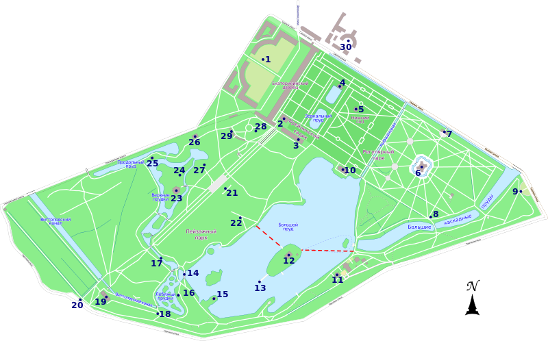
Русский: План Екатерининского парка в городе Пушкине под Санкт-Петербургом. |
|||
| Date | ||||
| Source | Own work | |||
| Author | Kaidor | |||
| Permission (Reusing this file) |
I, the copyright holder of this work, hereby publish it under the following license: This file is licensed under the Creative Commons Attribution-Share Alike 3.0 Unported license.
|
|||
| Legend | Russian 1. Екатерининский дворец |
| Camera location | | View this and other nearby images on: OpenStreetMap |
|---|
File history
Click on a date/time to view the file as it appeared at that time.
| Date/Time | Thumbnail | Dimensions | User | Comment | |
|---|---|---|---|---|---|
| current | 15:51, 12 February 2013 | | 3,099 × 1,931 (1.29 MB) | Kaidor (talk | contribs) | Текст → в контур |
| 15:49, 12 February 2013 |  | 3,099 × 1,931 (1.23 MB) | Kaidor (talk | contribs) | Добавлены надписи | |
| 17:56, 11 February 2013 |  | 3,099 × 1,931 (1.22 MB) | Kaidor (talk | contribs) | Изменен дизайн цифр и надписей, добавлены маршруты парома. | |
| 11:48, 9 February 2013 |  | 3,099 × 1,931 (1.36 MB) | Kaidor (talk | contribs) | Исправлены водные объекты | |
| 18:08, 8 February 2013 |  | 3,099 × 1,931 (1.36 MB) | Kaidor (talk | contribs) | User created page with UploadWizard |
You cannot overwrite this file.
File usage on Commons
The following page uses this file:
File usage on other wikis
The following other wikis use this file:
- Usage on en.wikipedia.org
- Usage on fi.wikipedia.org
- Usage on ru.wikipedia.org