File:Carte physique, administrative et routiere de la France - No. 19-1 (Brue, 1830).jpg

Original file (9,812 × 7,069 pixels, file size: 12.49 MB, MIME type: image/jpeg)
Captions
Captions
Summary[edit]
| Description |
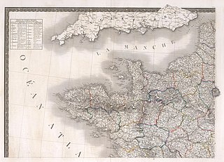
Français : Carte physique, administrative et routière de la France, indiquant aussi la navigation intérieure du royaume ; Par A.H. Brue, Geographer du Roi ... A Paris. Chez J. Goujon et J. Andriveau, Geographers-éditeures ... 1830. (inset) Corsica. (to accompany) Atlas de choix ou Recueil de cartes de géographie ancienne et moderne.
Scale 1:950,000 |
||||
| Date | 1830 | ||||
| Source | David Rumsey Map Collection. | ||||
| Author | Brue, Adrien Hubert, 1786-1832 | ||||
| Permission (Reusing this file) |
|
||||
| Other versions |
|
||||
.jpg)
.jpg)
.jpg)
.jpg)
.jpg&action=edit§ion=1)
File history
Click on a date/time to view the file as it appeared at that time.
| Date/Time | Thumbnail | Dimensions | User | Comment | |
|---|---|---|---|---|---|
| current | 14:19, 10 June 2019 | | 9,812 × 7,069 (12.49 MB) | FDRMRZUSA (talk | contribs) | User created page with UploadWizard |
You cannot overwrite this file.
File usage on Commons
The following 4 pages use this file:
- File:Carte physique, administrative et routiere de la France - No. 19-1 (Brue, 1830).jpg
- File:Carte physique, administrative et routiere de la France - No. 20-2 (Brue, 1830).jpg
- File:Carte physique, administrative et routiere de la France - No. 21-3 (Brue, 1830).jpg
- File:Carte physique, administrative et routiere de la France - No. 22-4 (Brue, 1830).jpg
.jpg&oldid=849287783)