File:Carte des prêtres assermentés en France en 1791.svg
Jump to navigation
Jump to search

Size of this PNG preview of this SVG file: 507 × 507 pixels. Other resolutions: 240 × 240 pixels | 480 × 480 pixels | 768 × 768 pixels | 1,024 × 1,024 pixels | 2,048 × 2,048 pixels.
Original file (SVG file, nominally 507 × 507 pixels, file size: 154 KB)
Captions
Captions
Add a one-line explanation of what this file represents
Clickable map
[edit]
Clickable version
Summary
[edit]| Description |
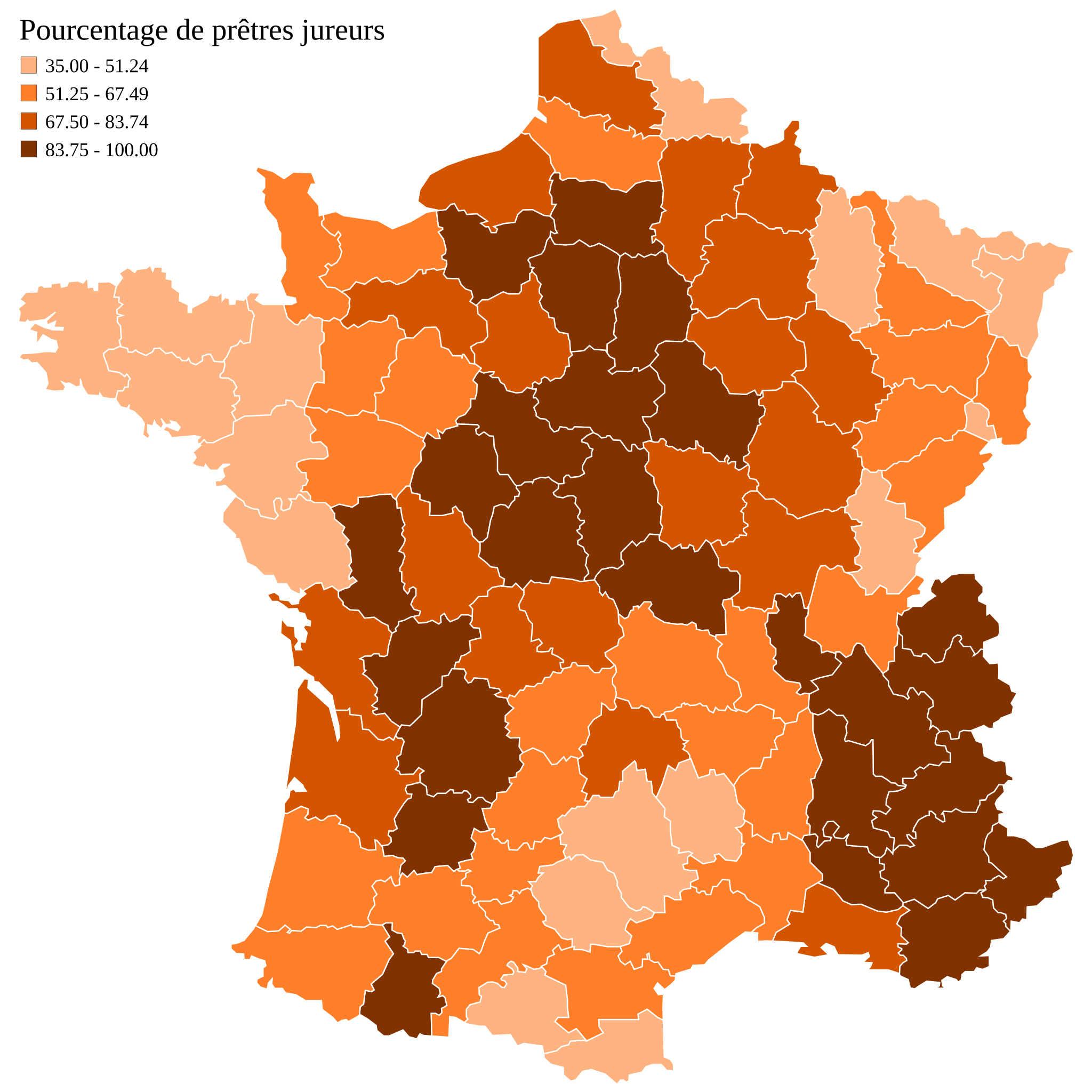
English: Map of France showing the percentage of priests who had sworn allegiance to the Civil Constitution of the Clergy, in 1791. Note : the borders (national & regional) are those of 2007 France and not 1791, due to the fact that data comes from departemental archives. Data from French historian Michel Vovelle, La révolution, l'Église et la France. Le serment de 1791 (1985). Français : Carte donnant le pourcentage de prêtres ayant prêté serment à la Constitution civile du clergé en France en 1791. Attention : les frontières ne sont pas celles de 1791, mais les données provenant d'archives départementales, ce découpage a été retenu. Données compilées par l'historien français Michel Vovelle, La révolution, l'Église et la France. Le serment de 1791 (1985). |
||
| Date | |||
| Source | Based on Image:Carte des prêtres assermentés en France en 1791.png and Image:Départements de France-simple.svg | ||
| Author | Marmelad | ||
| Permission (Reusing this file) |
|||
| Attribution (required by the license) | © Sémhur / Wikimedia Commons / | ||
| SVG | W3C-validity not checked.
|
||
| Graphic Lab |

| Camera location | | View this and other nearby images on: OpenStreetMap |
|---|
Licensing
[edit]
I, the copyright holder of this work, hereby publish it under the following licenses:
| Copyleft: This work of art is free; you can redistribute it and/or modify it according to terms of the Free Art License. You will find a specimen of this license on the Copyleft Attitude site as well as on other sites. |
This file is licensed under the Creative Commons Attribution-Share Alike Attribution-Share Alike 4.0 International, 3.0 Unported, 2.5 Generic, 2.0 Generic and 1.0 Generic license.
- You are free:
- to share – to copy, distribute and transmit the work
- to remix – to adapt the work
- Under the following conditions:
- attribution – You must give appropriate credit, provide a link to the license, and indicate if changes were made. You may do so in any reasonable manner, but not in any way that suggests the licensor endorses you or your use.
- share alike – If you remix, transform, or build upon the material, you must distribute your contributions under the same or compatible license as the original.
You may select the license of your choice.
File history
Click on a date/time to view the file as it appeared at that time.
| Date/Time | Thumbnail | Dimensions | User | Comment | |
|---|---|---|---|---|---|
| current | 12:40, 24 January 2008 | | 507 × 507 (154 KB) | Sémhur (talk | contribs) | Recentrage de la carte et correction de pourcentages |
| 13:21, 10 September 2007 |  | 507 × 553 (149 KB) | Sémhur (talk | contribs) | Correction d'une balise incorrecte | |
| 13:13, 10 September 2007 | No thumbnail | (149 KB) | Sémhur (talk | contribs) | Fusion des actuels départements 75, 78, 91, 92, 93, 94 et 95 en une seule zone, car le pourcentage indiqué porte sur l'ensemble de cette zone, et non sur chacun des départements (qui n'existaient pas en 1791) | |
| 11:26, 10 September 2007 |  | 507 × 553 (152 KB) | Historicair (talk | contribs) | Reverted to version as of 23:36, 9 September 2007 | |
| 11:25, 10 September 2007 | No thumbnail | (149 KB) | Historicair (talk | contribs) | ||
| 11:20, 10 September 2007 |  | 507 × 553 (152 KB) | Historicair (talk | contribs) | Reverted to version as of 23:36, 9 September 2007 | |
| 11:18, 10 September 2007 | No thumbnail | (148 KB) | Historicair (talk | contribs) | ||
| 23:36, 9 September 2007 |  | 507 × 553 (152 KB) | Marmelad (talk | contribs) | {{Information |Description=Français : Carte donnant le pourcentage de prêtres ayant prêté serment à la Constitution civile du clergé en France en 1791. |Source=Based on Image:Carte des prêtres assermentés en France en 1791.png and [[:Image:D� |
You cannot overwrite this file.
File usage on Commons
The following 3 pages use this file:
File usage on other wikis
The following other wikis use this file:
- Usage on cs.wikipedia.org
- Usage on de.wikipedia.org
- Usage on en.wikipedia.org
- Usage on es.wikipedia.org
- Usage on fa.wikipedia.org
- Usage on fr.wikipedia.org
- Histoire de la Drôme
- Guerre de Vendée
- Martincourt-sur-Meuse
- Église constitutionnelle
- Utilisateur:Zigeuner~frwiki
- Wikipédia:Atelier graphique/Images à améliorer/Archives/Septembre 2007
- Utilisateur:Zigeuner/Contributions
- Wikipédia:Le Bistro/17 mars 2010
- Diocèse de Sedan
- Utilisateur:Zigeuner
- Curés rouges
- Usage on he.wikipedia.org
- Usage on hy.wikipedia.org
- Usage on it.wikipedia.org
- Usage on ja.wikipedia.org
- Usage on lb.wikipedia.org
- Usage on nl.wikipedia.org
- Usage on no.wikipedia.org
- Usage on pt.wikipedia.org
- Usage on ru.wikipedia.org
- Usage on sh.wikipedia.org
- Usage on sr.wikipedia.org
- Usage on th.wikipedia.org
- Usage on uk.wikipedia.org
- Usage on zh.wikipedia.org