File:Carte des Alpes The Partizione delle Alpi.jpg
Jump to navigation
Jump to search

Size of this preview: 800 × 528 pixels. Other resolutions: 320 × 211 pixels | 640 × 422 pixels | 1,024 × 676 pixels | 1,280 × 845 pixels | 2,350 × 1,551 pixels.
Original file (2,350 × 1,551 pixels, file size: 4.13 MB, MIME type: image/jpeg)
Captions
Captions
Add a one-line explanation of what this file represents
Summary[edit]
| Description |
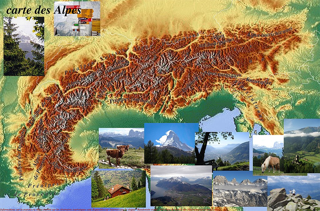
Français : Chaînes de montagnes des Alpes marquées sur la carte :
1. Alpes occidentales : Alpes cottiennes, Alpes de Provence, Alpes du Dauphiné, Alpes grées, Alpes maritimes, Préalpes de Provence, Préalpes de Savoie, Préalpes du Dauphiné. 2. Alpes centrals : Alpes bavaroises, Alpes bernoises, Alpes glaronaises, Alpes lépontines, Alpes pennines, Alpes rhétiques, Préalpes lombardes, Préalpes Suisses. 3. Alpes orientales : Alpes autrichiennes, Alpes carniques, Alpes julienne, Alpes noriques, Alpes salzbourgeoises, Dolomites, Karavanke.
|
| Date | |
| Source | physicalmap.org |
| Author | physicalmap.org |
Licensing[edit]
This file is licensed under the Creative Commons Attribution-Share Alike 4.0 International license.
- You are free:
- to share – to copy, distribute and transmit the work
- to remix – to adapt the work
- Under the following conditions:
- attribution – You must give appropriate credit, provide a link to the license, and indicate if changes were made. You may do so in any reasonable manner, but not in any way that suggests the licensor endorses you or your use.
- share alike – If you remix, transform, or build upon the material, you must distribute your contributions under the same or compatible license as the original.
File history
Click on a date/time to view the file as it appeared at that time.
| Date/Time | Thumbnail | Dimensions | User | Comment | |
|---|---|---|---|---|---|
| current | 14:43, 1 July 2020 | | 2,350 × 1,551 (4.13 MB) | Maps world (talk | contribs) | ajout de photos des chaînes de montagnes des Alpes |
| 22:45, 21 June 2020 |  | 2,350 × 1,551 (3.32 MB) | Maps world (talk | contribs) | Uploaded a work by physicalmap.org from physicalmap.org with UploadWizard |
You cannot overwrite this file.
File usage on Commons
The following page uses this file: