File:Carte Phrygie-he.png
Jump to navigation
Jump to search
No higher resolution available.
Carte_Phrygie-he.png (483 × 444 pixels, file size: 59 KB, MIME type: image/png)
Captions
Captions
Add a one-line explanation of what this file represents
Summary[edit]
| Description |
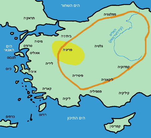
English: Map showing the traditional region of Phrygia and the manimum expansion of Phrygian kingdom in French. Adaptated from Image:Turkey ancient region map phrygia.jpg. |
| Date | 150809 |
| Source | File:Carte Phrygie.png Own translation by uploader |
| Author | רוליג |
| Other versions | File:Carte Phrygie.png |
Licensing[edit]
I, the copyright holder of this work, hereby publish it under the following licenses:
This file is licensed under the Creative Commons Attribution-Share Alike 3.0 Unported license.
- You are free:
- to share – to copy, distribute and transmit the work
- to remix – to adapt the work
- Under the following conditions:
- attribution – You must give appropriate credit, provide a link to the license, and indicate if changes were made. You may do so in any reasonable manner, but not in any way that suggests the licensor endorses you or your use.
- share alike – If you remix, transform, or build upon the material, you must distribute your contributions under the same or compatible license as the original.

|
Permission is granted to copy, distribute and/or modify this document under the terms of the GNU Free Documentation License, Version 1.2 or any later version published by the Free Software Foundation; with no Invariant Sections, no Front-Cover Texts, and no Back-Cover Texts. A copy of the license is included in the section entitled GNU Free Documentation License. |
You may select the license of your choice.
File history
Click on a date/time to view the file as it appeared at that time.
| Date/Time | Thumbnail | Dimensions | User | Comment | |
|---|---|---|---|---|---|
| current | 18:40, 15 August 2009 | | 483 × 444 (59 KB) | רוליג (talk | contribs) | m |
| 18:22, 15 August 2009 |  | 483 × 444 (59 KB) | רוליג (talk | contribs) | m | |
| 18:06, 15 August 2009 |  | 483 × 444 (59 KB) | רוליג (talk | contribs) | {{Information |Description={{en|1=Map showing the traditional region of Phrygia and the manimum expansion of Phrygian kingdom in French. Adaptated from Image:Turkey ancient region map phrygia.jpg.}} |Source=File:Carte Phrygie.png Own translation by u |
You cannot overwrite this file.
File usage on Commons
The following page uses this file:
File usage on other wikis
The following other wikis use this file:
- Usage on he.wikipedia.org