File:Carte Générale Des Découvertes De L'Amiral De Fonte representant la grande probabilité d'un Passage Au Nord Ouest Par Thomas (MAPS 91).jpg

Original file (6,828 × 6,108 pixels, file size: 7.95 MB, MIME type: image/jpeg)
Captions
Captions
|
|
|
This image was automatically transferred from the collections of the University of Washington. While certainly the majority of metadata in their database is correct, it is not necessarily written by individuals who are expert on the material they are describing. Such images often have incorrect dates, locations, or other information. If you can verify that this information is correct, or correct it if it isn't, please do so and remove this template. Also, if you are correcting information, please also let the library know so that they can update the metadata on their site. You can contact UW LIBRARIES MSCUA at photos |
Summary
[edit]| Title |
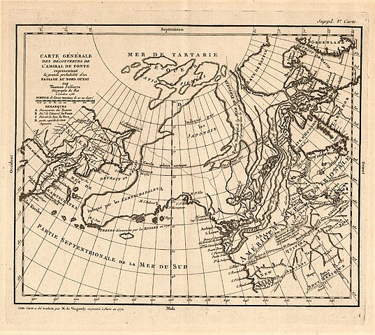
English: Carte Générale Des Découvertes De L'Amiral De Fonte representant la grande probabilité d'un Passage Au Nord Ouest Par Thomas Jefferys |
|||||||||||||||||||||||
| Description |
English: Copper engraving. Printed in upper left corner: ”Carte Générale Des Découvertes De L’Amiral De Fonte representant la grande probabilité d’un Passage Au Nord Ouest Par Thomas Jefferys Géographe du Roi á Londres 1768.” Printed beneath the title in the upper left corner is a scale for marine leagues. Printed beneath the scale in the upper left corner is a key using letters to show discoveries made by the Russians, a discovery of the Northwest Passage made by Admiral de Fonte, and discoveries made by Juan de Fuca and parts copied from a Japanese map. Printed in the upper right corner outside the border: ”Suppl. 8e. Carte.” Printed in the lower left corner outside the border: ”Cette Carte a été traduite par M. de Vaugondy et grave á Paris en 1772.” Shows Siberia, the Kamchatka Peninsula, Alaska, the Bering Strait and the northwestern edge of North America. Displays the mythical lands of “Quivira” and “Anian” in North America and shows northern California as “New Albion.” Shows a large river running west to east from the Strait of Juan de Fuca far inland to Mer de Ronquillo. Shows Alaska as land discovered by the Russians in 1741 and incorrectly defines its shape. Includes notes and names of Native American places. Shows Hudson’s and Baffin’s Bays. Also includes discoveries made by Captain Vitus Bering and Aleksei Chirikov.Thomas Jefferys (c.a. 1710-1771) was one of the most significant English cartographers of the eighteenth century. Working as an engraver, geographer and publisher, he created some of the most important English and American maps of his day. He was appointed Geographer to Frederick Prince of Wales in 1748 and later served as Geographer to George III. One of his first maps is a “Plan of London and Westminster” (1732). His other works include Kitchin’s “Small English Atlas” (1749), “”Map of Staffordshire” with Parson and Bowles (1747), engravings for Salmon’s “Geography” (1749), a last published edition of Saton’s “Atlas” (1752), and “Maritime Ports of France” (1761). Between 1751 and 1768, he published a number of other maps, mainly of America and the West Indies including Fry and Jefferson’s “Virginia” (1751), “Nova Scotia” (1755), De Braham’s “Carolina”’ (1757), “St. Lawrence” by Captain cook (1760), a volume on “Spanish Islands and West Indies’ (1762), and “Topography of North America and the West Indies” (1768). He also surveyed and engraved “county maps of Bedfordshire” (1765), “Hampshire” (1766), “Oxfordshire” (1766-7), “Durham and West” (1768), “Buckinghamshire” (1770) and “Yorkshire” (1767-70). Despite his prolific nature, Jefferys found himself bankrupt in 1765. Many of his plates were acquired by Robert Sayer who published much of Jeffreys’ work in “North American Atlas” (1775), “West Indian Atlas” (1775) and “North American Pilot” (1775). Jefferys later partnered with William Faden who received Jefferys’ shop when he died in 1771 (Tooley 335). Didier Robert de Vaugondy (1723-1786) was Royal Geographer and Censor in France (Tooley, 541). The Robert de Vaugondy family was descended from the Nicolas Sanson family and had much of his map plates. The family combined his plates with those of Hubert Jaillot’s plates after his death in 1712. Combining the map plates and thoroughly revising the earlier engravings, the family created the “Atlas Universal” (1750-1757) (Moreland and Bannister, 136). Didier’s work includes: “Mexico” (1749), “Maps in Atlas Universal” (1750-1757), “Nouvel Atlas portative” (1784), and “America Septentrionale” (1761). His atlases were later reissued by Delamarche (Tooley, 541). This map was first created by Thomas Jefferys in 1768 and re-engraved and republished by Didier Robert de Vaugondy in 1772 for his supplement “Encylopedie” covering the depiction of the fabled Northwest Passage (Phillips, 627, no. 1195; Wagner, 342, entry 637). Of note, the map combines accounts of Russian exploration with “apocryphal” accounts of exploration by Admiral Bartholomew de Fonte who claimed to have found a Northwest Passage in 1709 and Juan de Fuca (“Northwest Passage: Imaginary Voyages”). Source(s) Moreland, Carl and David Bannister. “Antique Maps: A Collector’s Handbook.” New York: Longman Group, Ltd., 1983. ”Northwest Passage: Imaginary Voyages.” Princeton University. Accessed 6 January 2009. Phillips, Philip Lee. “List of Geographical Atlases.” Vol.1. Washington, D.C.: Government Printing Office, 1909. Tooley, Ronald Vere. “Tooley’s Dictionary of Mapmakers.” Hertfordshire: Map Collector Publications Limited, 1979. Wagner, Henry R. “The Cartography of the Northwest Coast of America to the year 1800 Volume 2.” Berkeley: University of California Press, 1937.
|
|||||||||||||||||||||||
| Publisher | Robert de Vaugondy, Didier 1723-1786 | |||||||||||||||||||||||
| Digital ID Number | MAP146 | |||||||||||||||||||||||
| Condition | Tape on verso on top edge. Frayed along top and bottom edges. | |||||||||||||||||||||||
| Date | between 1768 and 1772 | |||||||||||||||||||||||
| Source |
English: World and Regional Maps Collection |
|||||||||||||||||||||||
| Creator |
English: Jefferys, Thomas, d.
|
|||||||||||||||||||||||
| Contributor |
English: Fuentes, Bartolome de 17th cent English: Fuca, Juan de English: Bering, Vitus Jonassen English: Chirikov, Aleksei Il'ich |
|||||||||||||||||||||||
| Permission (Reusing this file) |
|
|||||||||||||||||||||||
| Geotemporal data | ||||||||||||||||||||||||
| Map location | Alaska | |||||||||||||||||||||||
| Georeferencing | If inappropriate please set warp_status = skip to hide. | |||||||||||||||||||||||
| Bibliographic data | ||||||||||||||||||||||||
| Publication |
"The Great Probability of a Northern Passage." Theodorus Swaine Drage. London: 1768. "Encylopedie." Supplement. Robert de Vaugondy, Didier. Livourne: Didier Robert de Vaugondy, 1779. |
|||||||||||||||||||||||
| Place of publication |
English: France--Livourne |
|||||||||||||||||||||||
| Archival data | ||||||||||||||||||||||||
| Collection |
|
|||||||||||||||||||||||
| Accession number | ||||||||||||||||||||||||
| Dimensions | height: 29 cm (11.4 in); width: 37 cm (14.5 in) | |||||||||||||||||||||||

.jpg&action=edit§ion=1)
File history
Click on a date/time to view the file as it appeared at that time.
| Date/Time | Thumbnail | Dimensions | User | Comment | |
|---|---|---|---|---|---|
| current | 05:49, 8 July 2022 | | 6,828 × 6,108 (7.95 MB) | BMacZeroBot (talk | contribs) | Batch upload (Commons:Batch uploading/University of Washington Digital Collections) |
You cannot overwrite this file.
File usage on Commons
There are no pages that use this file.
.jpg&oldid=868495969)