File:Carte Fr Hittites.png
Jump to navigation
Jump to search

Size of this preview: 800 × 505 pixels. Other resolutions: 320 × 202 pixels | 640 × 404 pixels | 1,024 × 647 pixels | 1,280 × 809 pixels | 1,920 × 1,213 pixels.
Original file (1,920 × 1,213 pixels, file size: 485 KB, MIME type: image/png)
Captions
Captions
French translation of Sémhur's english [https://commons.wikimedia.org/wiki/File:Map_Hittite_rule_en.svg]
Summary
[edit]
| Description |
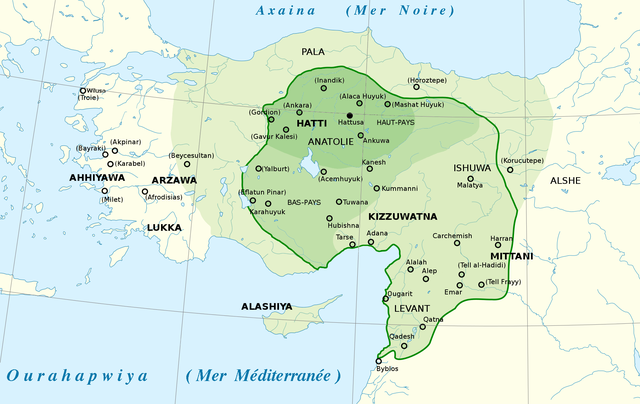
English: French map of the Hittite Empire, approximate extent of the maximum area of the Hittite rule (light green) and the Hittite rule ca. 1350-1300 BC (green line) Français : Version française de la carte de Sémhur File:Map_Hittite_rule_en.svg |
| Date | |
| Source |
|
| Author | Sémhur, translated by Claude Zygiel |
| Permission (Reusing this file) |
Own work |
Licensing
[edit]
I, the copyright holder of this work, hereby publish it under the following license:
This file is licensed under the Creative Commons Attribution-Share Alike 4.0 International license.
- You are free:
- to share – to copy, distribute and transmit the work
- to remix – to adapt the work
- Under the following conditions:
- attribution – You must give appropriate credit, provide a link to the license, and indicate if changes were made. You may do so in any reasonable manner, but not in any way that suggests the licensor endorses you or your use.
- share alike – If you remix, transform, or build upon the material, you must distribute your contributions under the same or compatible license as the original.
File history
Click on a date/time to view the file as it appeared at that time.
| Date/Time | Thumbnail | Dimensions | User | Comment | |
|---|---|---|---|---|---|
| current | 17:07, 2 June 2021 | | 1,920 × 1,213 (485 KB) | Claude Zygiel (talk | contribs) | Uploaded own work with UploadWizard |
You cannot overwrite this file.
File usage on Commons
The following page uses this file:
File usage on other wikis
The following other wikis use this file:
- Usage on fr.wikipedia.org
- Usage on uz.wikipedia.org