File:Carduelis chloris distribution map.png
Jump to navigation
Jump to search

Size of this preview: 800 × 353 pixels. Other resolutions: 320 × 141 pixels | 640 × 282 pixels | 1,425 × 628 pixels.
Original file (1,425 × 628 pixels, file size: 37 KB, MIME type: image/png)
Captions
Captions
Add a one-line explanation of what this file represents

|
This map of the world image could be re-created using vector graphics as an SVG file. This has several advantages; see Commons:Media for cleanup for more information. If an SVG form of this image is available, please upload it and afterwards replace this template with
{{vector version available|new image name}}.
It is recommended to name the SVG file “Carduelis chloris distribution map.svg”—then the template Vector version available (or Vva) does not need the new image name parameter. |
Summary[edit]
| Description |
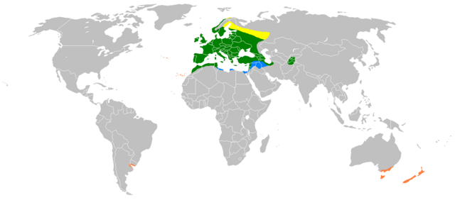
Distribution map of Carduelis chloris. Yellow: Breeding summer visitor Green: Breeding resident Blue: Non-breeding winter visitor Orange: Human-introduced populations |
| Date | Unknown date |
| Source | Compiled from Snow & Perrins Birds of the Western Palearctic, and Clement et al. Finches & Sparrows. |
| Author | Myself :User:Gretaz with Paint, edited by User:MPF. |
Licensing[edit]
| I, the copyright holder of this work, release this work into the public domain. This applies worldwide. In some countries this may not be legally possible; if so: I grant anyone the right to use this work for any purpose, without any conditions, unless such conditions are required by law. |
This image has been categorised by project WikiProject Birds
File history
Click on a date/time to view the file as it appeared at that time.
| Date/Time | Thumbnail | Dimensions | User | Comment | |
|---|---|---|---|---|---|
| current | 21:16, 20 March 2018 | | 1,425 × 628 (37 KB) | Maphobbyist (talk | contribs) | South Sudan border |
| 14:46, 4 April 2009 |  | 1,425 × 625 (49 KB) | MPF (talk | contribs) | More detailed version | |
| 18:45, 23 February 2007 |  | 1,425 × 625 (48 KB) | Gretaz (talk | contribs) | {{Information |Description=Distribution map of the European Greenfinch. |Source= [http://www.bsc-eoc.org/avibase/avibase.jsp?pg=map&lang=FR&id=A9C671684B04D24F&ts=1164920398513 This map] from [http://www.bsc-eoc.org Avibase] |Date= |Author=Myself :[[U |
You cannot overwrite this file.
File usage on Commons
The following 5 pages use this file:
File usage on other wikis
The following other wikis use this file:
- Usage on ar.wikipedia.org
- Usage on ast.wikipedia.org
- Usage on ba.wikipedia.org
- Usage on be.wikipedia.org
- Usage on bg.wikipedia.org
- Usage on ca.wikipedia.org
- Usage on ca.wikiquote.org
- Usage on da.wikipedia.org
- Usage on el.wikipedia.org
- Usage on es.wikipedia.org
- Usage on eu.wikipedia.org
- Usage on frr.wikipedia.org
- Usage on fr.wikipedia.org
- Usage on fy.wikipedia.org
- Usage on ga.wikipedia.org
- Usage on gl.wikipedia.org
- Usage on hy.wikipedia.org
- Usage on ia.wikipedia.org
- Usage on it.wikipedia.org
- Usage on kab.wikipedia.org
- Usage on kbd.wikipedia.org
- Usage on lt.wikipedia.org
- Usage on lv.wikipedia.org
- Usage on nl.wikipedia.org
- Usage on nn.wikipedia.org
- Usage on no.wikipedia.org
- Usage on pl.wikipedia.org
- Usage on pt.wikipedia.org
- Usage on sr.wikipedia.org
- Usage on sv.wikipedia.org
- Usage on tr.wikipedia.org
- Usage on uk.wikipedia.org
- Usage on vls.wikipedia.org
- Usage on www.wikidata.org
- Usage on zh.wikipedia.org