File:Capa que buza río arriba.png
Jump to navigation
Jump to search
Size of this preview: 800 × 389 pixels. Other resolutions: 320 × 156 pixels | 979 × 476 pixels.
Original file (979 × 476 pixels, file size: 104 KB, MIME type: image/png)
Captions
Captions
layer that dives upriver
Summary[edit]
| Description |
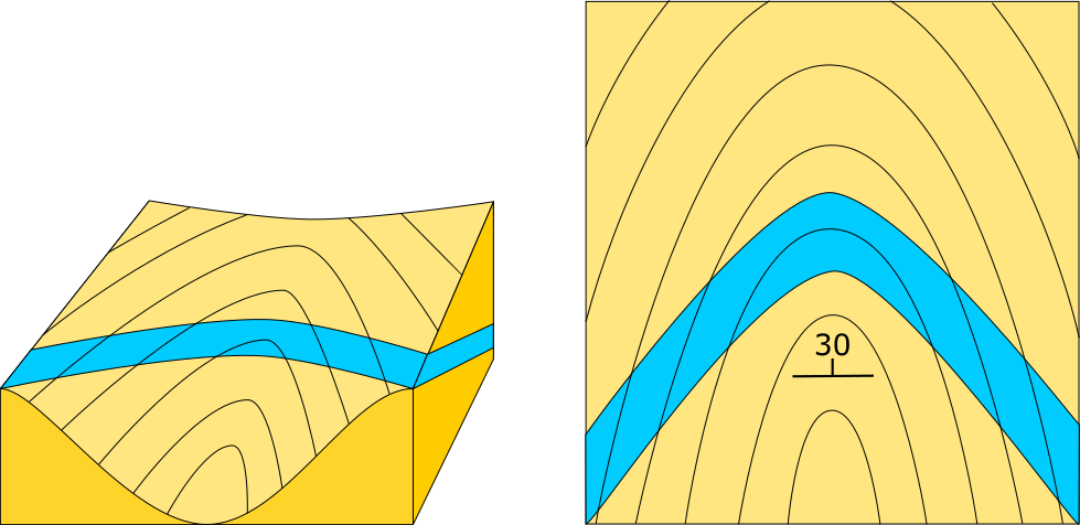
Español: Capas inclinadas río arriba: producen un patrón en el cual las trazas cortan las curvas de nivel topográfico y en los valles forman una V cuyo ápice apunta río arriba.
English: Layers inclined upstream: produce a pattern in which the traces intersect the topographic contour curves and in the valleys form a V whose apex points upstream. |
| Date | |
| Source | Own work |
| Author | Chiche Ojeda |
| Camera location | | View this and other nearby images on: OpenStreetMap |
|---|
Licensing[edit]
I, the copyright holder of this work, hereby publish it under the following license:
This file is licensed under the Creative Commons Attribution-Share Alike 4.0 International license.
- You are free:
- to share – to copy, distribute and transmit the work
- to remix – to adapt the work
- Under the following conditions:
- attribution – You must give appropriate credit, provide a link to the license, and indicate if changes were made. You may do so in any reasonable manner, but not in any way that suggests the licensor endorses you or your use.
- share alike – If you remix, transform, or build upon the material, you must distribute your contributions under the same or compatible license as the original.
File history
Click on a date/time to view the file as it appeared at that time.
| Date/Time | Thumbnail | Dimensions | User | Comment | |
|---|---|---|---|---|---|
| current | 12:25, 22 April 2020 | | 979 × 476 (104 KB) | Chiche Ojeda (talk | contribs) | Uploaded own work with UploadWizard |
You cannot overwrite this file.
File usage on Commons
There are no pages that use this file.
File usage on other wikis
The following other wikis use this file:
- Usage on es.wikipedia.org
- Usage on fr.wikipedia.org