File:Canaryislands tmo 2013166 lrg(2).jpg
Jump to navigation
Jump to search

Size of this preview: 780 × 600 pixels. Other resolutions: 312 × 240 pixels | 624 × 480 pixels | 999 × 768 pixels | 1,280 × 985 pixels | 2,600 × 2,000 pixels.
Original file (2,600 × 2,000 pixels, file size: 1,006 KB, MIME type: image/jpeg)
Captions
Captions
Add a one-line explanation of what this file represents
Summary[edit]
.jpg&action=edit§ion=1)
| Description |
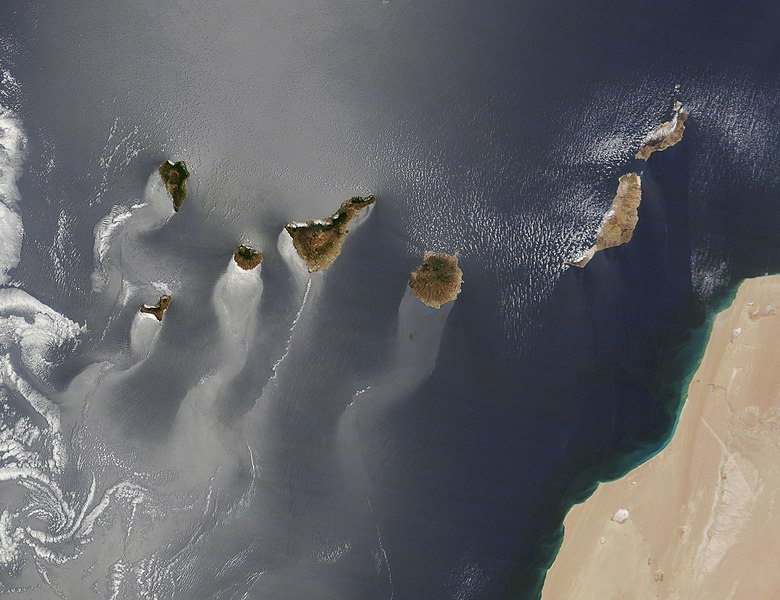
Español: El viento del Noreste (Alisios del noreste) deja una especie de estela a sotavento de cada isla del archipiélago de las Canarias, al rodear el agua superficial a cada isla en particular. |
| Date | |
| Source | Publicación del gobierno de los Estados Unidos |
| Author | NASA IOTD |
| Camera location | | View this and other nearby images on: OpenStreetMap |
|---|
.jpg¶ms=028.536000_N_-015.749000_E_globe:Earth_type:camera__&language=en)
Licensing[edit]
.jpg&action=edit§ion=2)
| This file is in the public domain in the United States because it was solely created by NASA. NASA copyright policy states that "NASA material is not protected by copyright unless noted". (See Template:PD-USGov, NASA copyright policy page or JPL Image Use Policy.) | ||
 |
Warnings:
|
File history
Click on a date/time to view the file as it appeared at that time.
| Date/Time | Thumbnail | Dimensions | User | Comment | |
|---|---|---|---|---|---|
| current | 18:48, 16 September 2020 | | 2,600 × 2,000 (1,006 KB) | Fev (talk | contribs) | Uploaded a work by NASA IOTD from Publicación del gobierno de los Estados Unidos with UploadWizard |
You cannot overwrite this file.
File usage on Commons
The following page uses this file:
.jpg&oldid=863263970)