File:Cairo city administrative boundary and districts En.jpg
Jump to navigation
Jump to search

Size of this preview: 424 × 599 pixels. Other resolutions: 170 × 240 pixels | 339 × 480 pixels | 543 × 768 pixels | 724 × 1,024 pixels | 1,654 × 2,338 pixels.
Original file (1,654 × 2,338 pixels, file size: 613 KB, MIME type: image/jpeg)
Captions
Captions
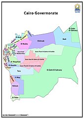
Cairo Governorate administrative boundary, showing Cairo City within it (Districts minus al-zahir al-sahrawy (desert hinterland)
Summary[edit]
| Description |
English: Administrative district divisions and city boundary |
| Date | |
| Source | http://www.cairo.gov.eg/en/Maps/Pages/cairo-areas.aspx |
| Author | Cairo Governorate GIS Unit |
Licensing[edit]
| This work is not an object of copyright in Egypt because it is an official document. Regardless of their source or target language, all official documents are ineligible for protection in Egypt, including laws, regulations, resolutions and decisions, international conventions, court decisions, award of arbitrators and decisions of administrative committees having judicial competence. (Article 141 of Intellectual Property Law 82 of 2002) | 
|
File history
Click on a date/time to view the file as it appeared at that time.
| Date/Time | Thumbnail | Dimensions | User | Comment | |
|---|---|---|---|---|---|
| current | 20:09, 23 February 2023 | | 1,654 × 2,338 (613 KB) | Ypedia1 (talk | contribs) | Uploaded a work by Cairo Governorate GIS Unit from http://www.cairo.gov.eg/en/Maps/Pages/cairo-areas.aspx with UploadWizard |
You cannot overwrite this file.
File usage on Commons
There are no pages that use this file.
File usage on other wikis
The following other wikis use this file:
- Usage on en.wikipedia.org
- Usage on vep.wikipedia.org