File:CPC-NWS-NOAA SST Anoms 08 JUL 2015.png
Jump to navigation
Jump to search

No higher resolution available.
CPC-NWS-NOAA_SST_Anoms_08_JUL_2015.png (500 × 225 pixels, file size: 98 KB, MIME type: image/png)
Captions
Captions
Add a one-line explanation of what this file represents
Summary
[edit]
| Description |
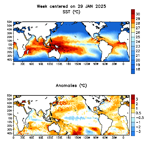
English: Global Tropical Sea Surface Temperature map, week centered 8 jul 2015. part of:
Global Tropical Sea Surface Temperature Animation. Weekly averaged sea surface temperatures (top, °C) and anomalies (bottom, °C) for the past twelve weeks. SST analysis is the optimum interpolation (OI) analysis, while anomalies are departures from the adjusted OI climatology (Reynolds and Smith 1995, J. Climate, 8, 1571-1583. (Text after NOAA, Global Tropical Sea Surface Temperature Animation) Illustrates 2015 European and U.S. Wast coast heat waves.
Français : Carte globale des températures de surface des mers tropicales, semaine du 8 juillet 2015 ; Animation globale de la température de surface des mers tropicales. Moyenne hebdomadaire des températures de la surface de la mer (en haut, en ° C) et des anomalies (en bas, en ° C) au cours des douze dernières semaines. L'analyse SST est l'analyse d'interpolation optimale (OI), alors que les anomalies sont des écarts par rapport à la climatologie OI ajustée (Reynolds et Smith 1995, J. Climate, 8, 1571-1583). Illustre les vagues de chaleur des côtes des États-Unis (mais aussi de la Méditerranée) en 2015. |
| Date | |
| Source | NOAA NCEP CPC > Monitoring and Data > Oceanic & Atmospheric Data > Weekly ENSO Update > Global Tropical Sea Surface Temperature Animation http://www.cpc.ncep.noaa.gov/products/analysis_monitoring/enso_update/gsstanim.gif |
| Author | NOAA / National Weather Service / National Centers for Environmental Prediction / Climate Prediction Center Internet Team |
Licensing
[edit]
| This file is in the public domain in the United States because it was solely created by NASA. NASA copyright policy states that "NASA material is not protected by copyright unless noted". (See Template:PD-USGov, NASA copyright policy page or JPL Image Use Policy.) | ||
 |
Warnings:
|
File history
Click on a date/time to view the file as it appeared at that time.
| Date/Time | Thumbnail | Dimensions | User | Comment | |
|---|---|---|---|---|---|
| current | 02:53, 14 July 2015 | | 500 × 225 (98 KB) | W!B: (talk | contribs) | =={{int:filedesc}}== {{Information |description={{en|1=Global Tropical Sea Surface Temperature map, week centered 8 jul 2015. part of: Global Tropical Sea Surface Temperature Animation. Weekly averaged sea surface temperatures (top, °C) and anomalies... |
You cannot overwrite this file.
File usage on Commons
There are no pages that use this file.
File usage on other wikis
The following other wikis use this file:
- Usage on de.wikipedia.org