File:C19a.jpg

Original file (3,409 × 2,254 pixels, file size: 608 KB, MIME type: image/jpeg)
Captions
Captions
Summary
[edit]
| Description |
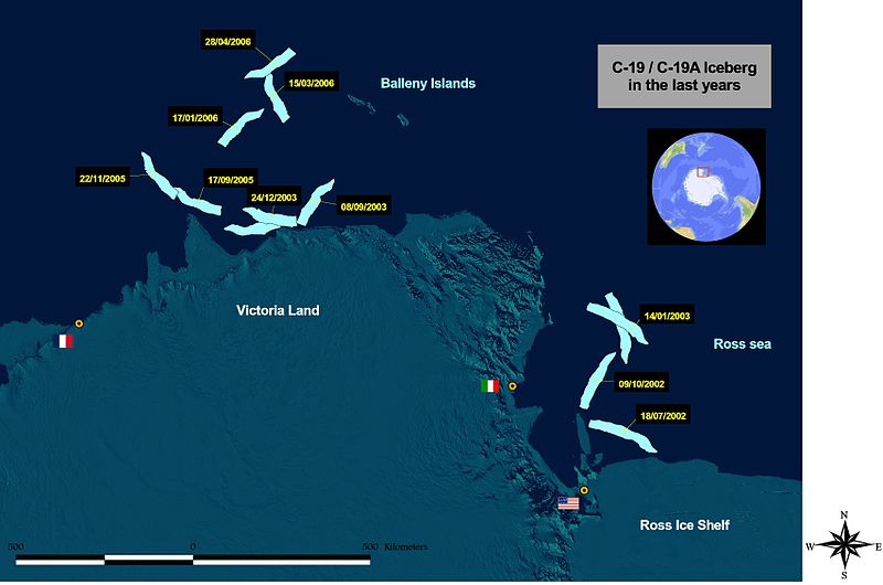
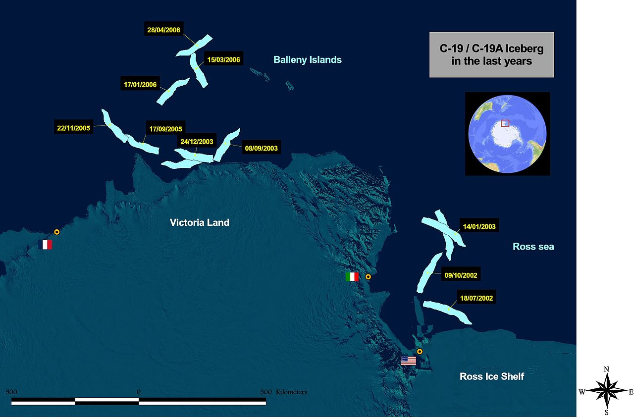
English: GIS image showing the position of C-19 iceberg from 2002 to May 2006. Image made by Luca Pietranera. Information on the iceberg poositions derived by NASA-MODIS images (MODIS Rapid Response Rroject at NASA/GSI) and European Space Agency (ESA) ENVISAT ENVISAT,MERIS and ASAR sensors images.
The background is a part of the MODIS mosaic of Antarctica (Haran, T., J. Bohlander, T. Scambos, and M. Fahnestock compilers. 2005. MODIS mosaic of Antarctica (MOA) image map. Boulder, CO, USA: National Snow and Ice Data Center. Digital media). Italian station "Mario Zucchelli", US McMurdo Station and French Dumont d'Urville Station are highlighted on the map. GIS image showing the position of C-19 iceberg from 2002 to May 2006. Image made by Luca Pietranera. Information on the iceberg poositions derived by NASA-MODIS images (MODIS Rapid Response Rroject at NASA/GSI) and European Space Agency (ESA) ENVISAT ENVISAT,MERIS and ASAR sensors images. The background is a part of the MODIS mosaic of Antarctica (Haran, T., J. Bohlander, T. Scambos, and M. Fahnestock compilers. 2005. MODIS mosaic of Antarctica (MOA) image map. Boulder, CO, USA: National Snow and Ice Data Center. Digital media). Italian station "Mario Zucchelli", US McMurdo Station and French Dumont d'Urville Station are highlighted on the map. |
| Date | |
| Source | Own work by the original uploader |
| Author | Lucapietranera (talk) (Uploads |
Licensing
[edit]
| This work has been released into the public domain by its author, Lucapietranera at English Wikipedia. This applies worldwide. In some countries this may not be legally possible; if so: Lucapietranera grants anyone the right to use this work for any purpose, without any conditions, unless such conditions are required by law. |
Original upload log
[edit]
- 2006-05-01 08:03 Lucapietranera 3409×2254× (622875 bytes)
- 2006-03-26 20:39 Lucapietranera 2050×1357× (378419 bytes)
- 2006-03-26 10:21 Lucapietranera 2050×1357× (350160 bytes) GIS image showing the position of C-19 iceberg from 2002 to March 2006. Image made by Luca Pietranera. Information on the iceberg poositions derived by NASA-MODIS images (MODIS Rapid Response Rroject at NASA/GSI) and European Space Agency (ESA) ENVISAT,ME
File history
Click on a date/time to view the file as it appeared at that time.
| Date/Time | Thumbnail | Dimensions | User | Comment | |
|---|---|---|---|---|---|
| current | 22:47, 28 December 2014 | | 3,409 × 2,254 (608 KB) | OgreBot (talk | contribs) | (BOT): Reverting to most recent version before archival |
| 22:47, 28 December 2014 |  | 2,050 × 1,357 (370 KB) | OgreBot (talk | contribs) | (BOT): Uploading old version of file from en.wikipedia; originally uploaded on 2006-03-26 20:39:36 by Lucapietranera | |
| 22:47, 28 December 2014 |  | 2,050 × 1,357 (342 KB) | OgreBot (talk | contribs) | (BOT): Uploading old version of file from en.wikipedia; originally uploaded on 2006-03-26 10:21:31 by Lucapietranera | |
| 20:32, 7 March 2014 |  | 3,409 × 2,254 (608 KB) | Frokor (talk | contribs) | == {{int:filedesc}} == {{Information |Description={{en|GIS image showing the position of C-19 iceberg from 2002 to May 2006. Image made by Luca Pietranera. Information on the iceberg poositions derived by NASA-MODIS images ([http://rapidfir... |
You cannot overwrite this file.
File usage on Commons
The following 2 pages use this file:
File usage on other wikis
The following other wikis use this file:
- Usage on en.wikipedia.org
- Usage on nn.wikipedia.org
- Usage on www.wikidata.org