File:Bydgoszcz regionalizacja fiz-geo.png
Jump to navigation
Jump to search

Size of this preview: 800 × 523 pixels. Other resolutions: 320 × 209 pixels | 640 × 418 pixels | 1,024 × 670 pixels | 1,300 × 850 pixels.
Original file (1,300 × 850 pixels, file size: 117 KB, MIME type: image/png)
Captions
Captions
Add a one-line explanation of what this file represents
Summary[edit]
| Description |
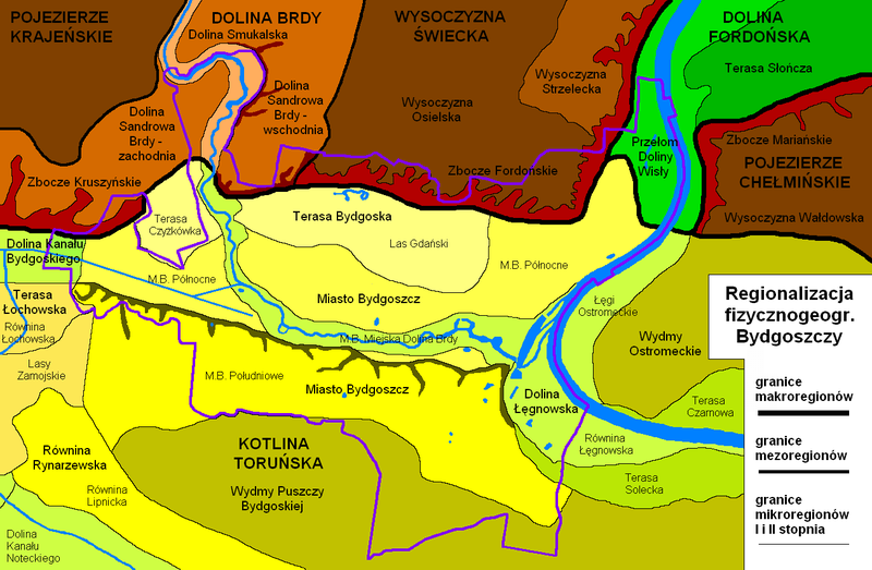
Polski: Regionalizacja fizycznogeograficzna Bydgoszczy - makro-, mezo- i mikroregiony I i II stopnia na podstawie "Środowisko przyrodnicze Bydgoszczy, red. J. Banaszak, 1996" |
| Date | 7 March 2013 (upload date) |
| Source | Own work |
| Author | Pit1233 |
Licensing[edit]
I, the copyright holder of this work, hereby publish it under the following license:
| This file is made available under the Creative Commons CC0 1.0 Universal Public Domain Dedication. | |
| The person who associated a work with this deed has dedicated the work to the public domain by waiving all of their rights to the work worldwide under copyright law, including all related and neighboring rights, to the extent allowed by law. You can copy, modify, distribute and perform the work, even for commercial purposes, all without asking permission.
|
File history
Click on a date/time to view the file as it appeared at that time.
| Date/Time | Thumbnail | Dimensions | User | Comment | |
|---|---|---|---|---|---|
| current | 08:53, 7 March 2013 | | 1,300 × 850 (117 KB) | Pit1233 (talk | contribs) |
You cannot overwrite this file.
File usage on Commons
The following page uses this file:
File usage on other wikis
The following other wikis use this file:
- Usage on pl.wikipedia.org
- Warunki naturalne w Bydgoszczy
- Fordoński Przełom Wisły
- Terasa Słończa
- Dolina Sandrowa Brdy
- Dolina Smukalska
- Zbocze Kruszyńskie
- Wysoczyzna Osielska
- Wysoczyzna Strzelecka
- Zbocze Fordońskie
- Dolina Kanału Bydgoskiego
- Terasa Bydgoska
- Miasto Bydgoszcz
- Wydmy Puszczy Bydgoskiej
- Terasa Łochowska
- Dolina Łęgnowska
- Wydmy Ostromeckie
- Równina Rynarzewska
- Zbocze Mariańskie
- Wysoczyzna Wałdowska
- Szablon:Jednostki fizycznogeograficzne w Bydgoszczy