File:Buurtspoorwegen prov Antwerpen.png
Jump to navigation
Jump to search

Size of this preview: 613 × 599 pixels. Other resolutions: 245 × 240 pixels | 491 × 480 pixels | 786 × 768 pixels | 1,047 × 1,024 pixels | 1,886 × 1,844 pixels.
Original file (1,886 × 1,844 pixels, file size: 1.13 MB, MIME type: image/png)
Captions
Captions
Add a one-line explanation of what this file represents
Summary[edit]
| Description |
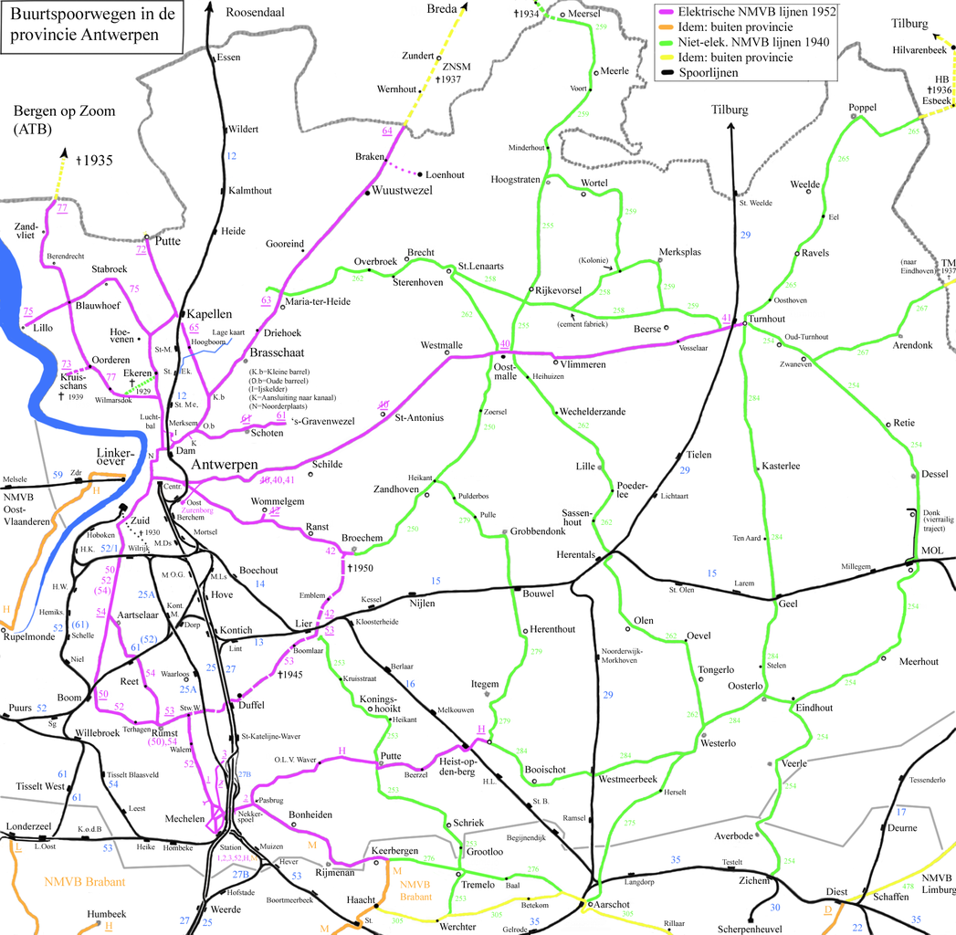
English: Map off the vicinal railways in the province off Antwerp.
Nederlands: Kaart van de buurtspoorwegen in de provincie Antwerpen. |
| Date | 3-12-2008 |
| Source | Own work |
| Author | Smiley.toerist |
| Other versions | Buurtspoorwegen Brabant.png |
Licensing[edit]
I, the copyright holder of this work, hereby publish it under the following licenses:

|
Permission is granted to copy, distribute and/or modify this document under the terms of the GNU Free Documentation License, Version 1.2 or any later version published by the Free Software Foundation; with no Invariant Sections, no Front-Cover Texts, and no Back-Cover Texts. A copy of the license is included in the section entitled GNU Free Documentation License. |
This file is licensed under the Creative Commons Attribution-Share Alike 3.0 Unported, 2.5 Generic, 2.0 Generic and 1.0 Generic license.
- You are free:
- to share – to copy, distribute and transmit the work
- to remix – to adapt the work
- Under the following conditions:
- attribution – You must give appropriate credit, provide a link to the license, and indicate if changes were made. You may do so in any reasonable manner, but not in any way that suggests the licensor endorses you or your use.
- share alike – If you remix, transform, or build upon the material, you must distribute your contributions under the same or compatible license as the original.
You may select the license of your choice.
File history
Click on a date/time to view the file as it appeared at that time.
| Date/Time | Thumbnail | Dimensions | User | Comment | |
|---|---|---|---|---|---|
| current | 20:37, 17 May 2014 | | 1,886 × 1,844 (1.13 MB) | Smiley.toerist (talk | contribs) | Correction: electrification to Broechem. The electric trams reversed there. |
| 10:57, 22 February 2011 |  | 1,886 × 1,844 (1.13 MB) | Smiley.toerist (talk | contribs) | Turnhout en Overbroek bijgewerkt | |
| 21:02, 15 November 2010 |  | 1,886 × 1,844 (1.13 MB) | Smiley.toerist (talk | contribs) | Aangepast Putte, Tremelo, Keerbergen, Haacht, Werchter, Aarschot, route Eindhout-Mol aan de hand van info out oude kaarten. | |
| 10:43, 30 August 2010 |  | 1,886 × 1,844 (1.13 MB) | Smiley.toerist (talk | contribs) | Coorections and added place names | |
| 16:02, 1 June 2010 |  | 1,886 × 1,844 (1.1 MB) | Smiley.toerist (talk | contribs) | ||
| 10:36, 16 March 2009 |  | 1,886 × 1,844 (1.08 MB) | Smiley.toerist (talk | contribs) | ||
| 10:51, 27 February 2009 |  | 1,886 × 1,844 (1.05 MB) | Smiley.toerist (talk | contribs) | ||
| 23:38, 18 December 2008 |  | 1,886 × 1,844 (1.03 MB) | Smiley.toerist (talk | contribs) | ||
| 14:13, 17 December 2008 |  | 1,886 × 1,844 (1.02 MB) | Smiley.toerist (talk | contribs) | ||
| 09:46, 15 December 2008 |  | 1,886 × 1,844 (1.02 MB) | Smiley.toerist (talk | contribs) |
You cannot overwrite this file.
File usage on Commons
The following 3 pages use this file:
File usage on other wikis
The following other wikis use this file:
- Usage on cs.wikipedia.org
- Usage on fr.wikipedia.org
- Société nationale des chemins de fer vicinaux
- Ligne de tramway 41 (Anvers)
- Ligne de tramway 61 (Anvers)
- Ligne de tramway 64 (Anvers)
- Ligne de tramway 65 (Anvers)
- Ligne de tramway 72 (Anvers)
- Ligne de tramway 75 (Anvers)
- Ligne de tramway 77 (Anvers)
- Ligne de tramway 42 (Anvers)
- Lignes de tramway de la SNCV dans la province d'Anvers
- Ligne de tramway 52 (Anvers)
- Ligne de tramway 279
- Ligne de tramway 1 (Malines)
- Ligne de tramway 2 (Malines)
- Ligne de tramway 3 (Malines)
- Ligne de tramway 276
- Ligne de tramway H (Malines)
- Ligne de tramway T (Malines)
- Ligne de tramway 53 (Anvers)
- Ligne de tramway 262
- Ligne de tramway 265
- Ligne de tramway 498
- Ligne de tramway 254
- Usage on nl.wikipedia.org