File:Bushman Fold Train DE.png
Jump to navigation
Jump to search

Size of this preview: 387 × 600 pixels. Other resolutions: 155 × 240 pixels | 309 × 480 pixels | 495 × 768 pixels | 660 × 1,024 pixels | 2,512 × 3,894 pixels.
Original file (2,512 × 3,894 pixels, file size: 5.62 MB, MIME type: image/png)
Captions
Captions
Add a one-line explanation of what this file represents
Summary[edit]
| Description |
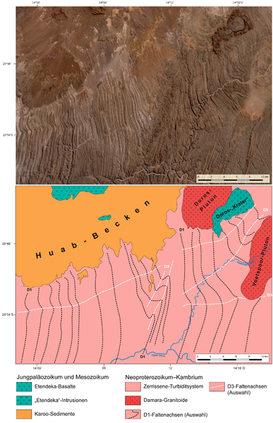
Deutsch: Satellitenbild (oben) und geologische Karte (unten) des Bushman-Faltenzuges (die S-förmige Struktur mit NNE-SSW-streichenden D3-Faltenachsen ungefähr in der Mitte beider Abbildungen) im Nordosten der Lower Ugab Domain (Southern Kaoko Zone) und angrenzender Gebiete, Zentral-Namibia.
English: Satellite image (top) and geological map (bottom) of the Bushman fold train (the s-shaped structure with NNE-SSW-trending D3 fold axes in the center of both figures) in the northeastern part of the Lower Ugab Domain (Southern Kaoko Zone) and adjacent areas, central Namibia. |
| Date | |
| Source |
Own work
|
| Author | Gretarsson |
This image was created with Adobe Photoshop.
Licensing[edit]
I, the copyright holder of this work, hereby publish it under the following license:
This file is licensed under the Creative Commons Attribution 4.0 International license.
- You are free:
- to share – to copy, distribute and transmit the work
- to remix – to adapt the work
- Under the following conditions:
- attribution – You must give appropriate credit, provide a link to the license, and indicate if changes were made. You may do so in any reasonable manner, but not in any way that suggests the licensor endorses you or your use.
File history
Click on a date/time to view the file as it appeared at that time.
| Date/Time | Thumbnail | Dimensions | User | Comment | |
|---|---|---|---|---|---|
| current | 01:02, 23 June 2017 | | 2,512 × 3,894 (5.62 MB) | Gretarsson (talk | contribs) | logitude in bottom figure corrected ("O" instead of "W") |
| 23:18, 22 June 2017 |  | 2,512 × 3,894 (5.62 MB) | Gretarsson (talk | contribs) | {{Information |Description ={{de|1=Satellitenbild (oben) und geologische Karte (unten) des Bushman-Faltenzuges (Lower Ugab Domain/Southern Kaoko Zone) und angrenzender Gebiete, Zentral-Namibia}} {{en|1=Satellite image (top) and geological map (botto... |
You cannot overwrite this file.
File usage on Commons
The following page uses this file:
File usage on other wikis
The following other wikis use this file:
- Usage on de.wikipedia.org