File:Burn Scar from the Smokehouse Creek Fire (MODIS 2024-03-05).jpg

Original file (1,380 × 1,167 pixels, file size: 233 KB, MIME type: image/jpeg)
Captions
Captions
Summary[edit]
.jpg&action=edit§ion=1)
| Description |
English: March 2, 2024 February 24, 2024
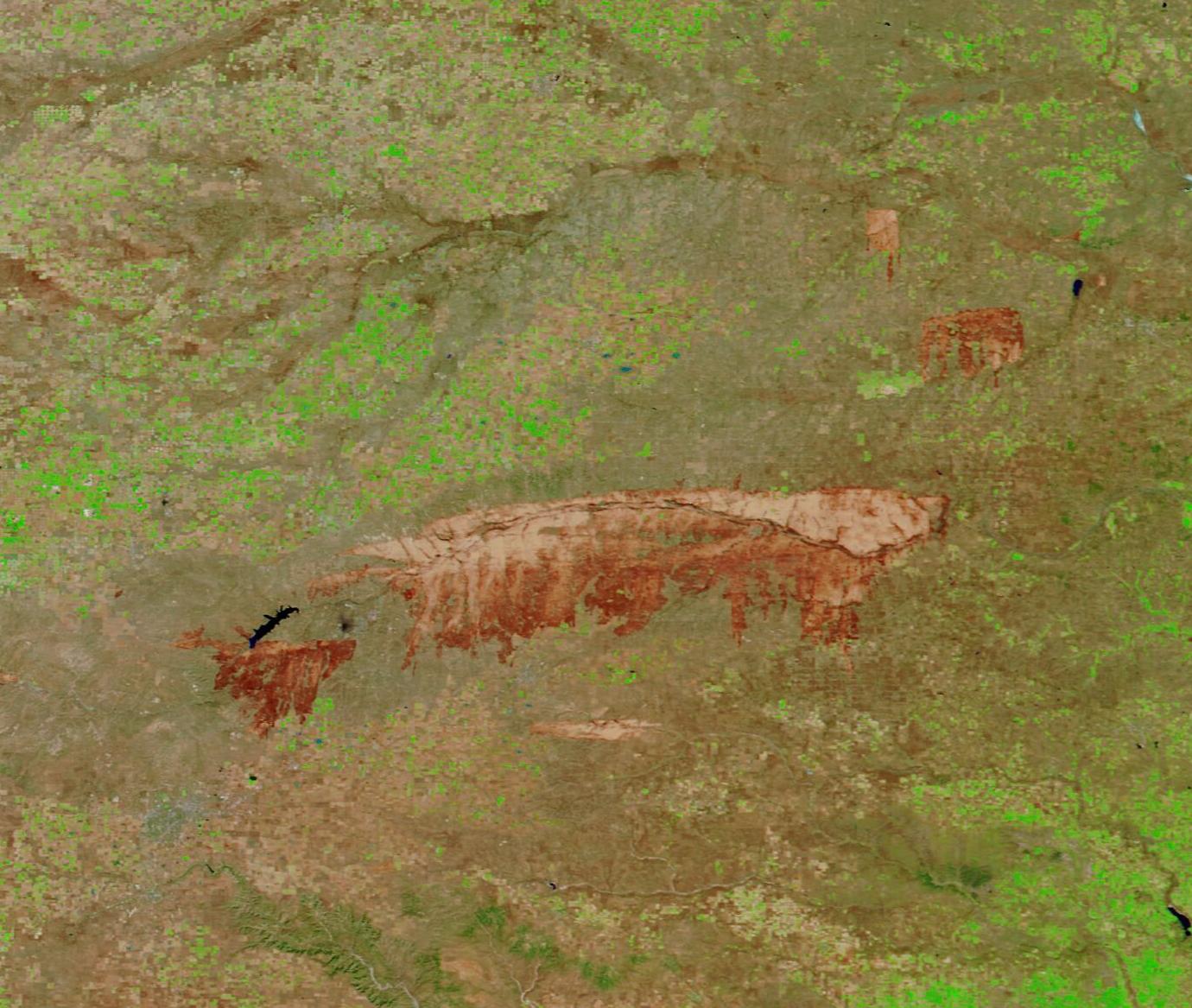
After a warm, dry winter, the tall- and short-grass prairies of the Texas Panhandle were crisp and dry as campfire tinder in the closing days of February 2024. When a strong storm system swept across the region on February 26-27, gusting winds of up to 50 miles turned the smallest spark into a roaring inferno. The result was a multi-day wildfire outbreak across both Texas and Oklahoma. Texas A&M Forest Service listed 13 large wildfires ignited on February 26, with several new fires listed on February 27. Many were quickly contained, but several expanded furiously. One of these, the Smokehouse Creek Fire, has become the largest fire in Texas history, scorching 1,076,638 acres as of March 4. After destroying hundreds of homes and causing the death of two people, that fire remains only 15 percent contained, according to Inciweb. On March 2, 2024, the Moderate Resolution Imaging Spectroradiometer (MODIS) on NASA’s Terra satellite acquired a false-color image centered on the burn scar from the Smokehouse Creek Fire. A second false-color image of the same area was acquired by Terra MODIS on February 24, 2024, just two days before the fire ignited. The two can be compared by clicking on the dates below the image. This type of false-color image uses infrared and visible light to help separate vegetation (green) from open land (tan tones) and water (blue). A burn scar is the area left behind after fire passes over land. Burn scars may vary in color, depending on many factors, such as type of soil, temperature of the fire, and how completely an area was burnt. Fresh burn scars often appear brick red in this type of image, as is the case across most of the Smokehouse Creek Fire burn scar. Using the measurement tool on NASA Worldview, the burn scar from the Smokehouse Creek Fire spans more than 1,500 square miles, which is an area substantially greater than the U.S. state of Rhode Island. In the east, the burn scar crosses the border into Oklahoma. Additional burn scars can be seen in the Oklahoma prairie north of the Smokehouse Creek Fire. Another large burn scar sits near the blue waters of Lake Meredith, southwest of Smokehouse Creek. That is the Windy Deuce Fire, which had scorched 144,206 acres and was 55 percent contained as of March 4. It also started on February 26. While the burn scars visible on March 4 are truly impressive, the full impact is realized only by clicking on the February 24 date and revealing the pristine Panhandle landscape. On that date, Lake Meredith is the highlight of the image, and the Canadian River can be easily seen sweeping across the green prairie grasses. By March 4, the fire-forged changes are stunning. The ferocity and rapidity of a fire that could wipe out such a large expanse of land in just five days is nearly unfathomable, but the images clearly document the reality of the historic and disastrous fire event. |
||
| Date | Taken on 2 March 2024 | ||
| Source |
Burn Scar from the Smokehouse Creek Fire (direct link)
|
||
| Author | MODIS Land Rapid Response Team, NASA GSFC |
| This media is a product of the Terra mission Credit and attribution belongs to the mission team, if not already specified in the "author" row |
Licensing[edit]
.jpg&action=edit§ion=2)
| This file is in the public domain in the United States because it was solely created by NASA. NASA copyright policy states that "NASA material is not protected by copyright unless noted". (See Template:PD-USGov, NASA copyright policy page or JPL Image Use Policy.) | ||
 |
Warnings:
|
File history
Click on a date/time to view the file as it appeared at that time.
| Date/Time | Thumbnail | Dimensions | User | Comment | |
|---|---|---|---|---|---|
| current | 21:41, 5 March 2024 | | 1,380 × 1,167 (233 KB) | OptimusPrimeBot (talk | contribs) | #Spacemedia - Upload of http://modis.gsfc.nasa.gov/gallery/images/image03052024_250m.jpg via Commons:Spacemedia |
You cannot overwrite this file.
File usage on Commons
There are no pages that use this file.
.jpg&oldid=858241655)