File:British and Irish Isles.svg
Jump to navigation
Jump to search

Size of this PNG preview of this SVG file: 621 × 600 pixels. Other resolutions: 248 × 240 pixels | 497 × 480 pixels | 795 × 768 pixels | 1,060 × 1,024 pixels | 2,120 × 2,048 pixels | 2,263 × 2,186 pixels.
Original file (SVG file, nominally 2,263 × 2,186 pixels, file size: 409 KB)
Captions
Captions
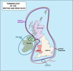
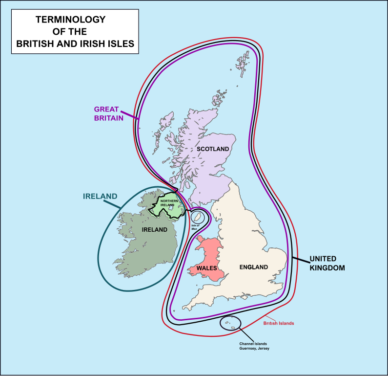
British and Irish Isles
Summary
[edit]
| Description |
English: Map of European Atlantic Archipelago Islands or British and Irish Isles |
| Date | |
| Source | Own work |
| Author | DrSmuggles |
Licensing
[edit]
I, the copyright holder of this work, hereby publish it under the following license:
This file is licensed under the Creative Commons Attribution-Share Alike 4.0 International license.
- You are free:
- to share – to copy, distribute and transmit the work
- to remix – to adapt the work
- Under the following conditions:
- attribution – You must give appropriate credit, provide a link to the license, and indicate if changes were made. You may do so in any reasonable manner, but not in any way that suggests the licensor endorses you or your use.
- share alike – If you remix, transform, or build upon the material, you must distribute your contributions under the same or compatible license as the original.
File history
Click on a date/time to view the file as it appeared at that time.
| Date/Time | Thumbnail | Dimensions | User | Comment | |
|---|---|---|---|---|---|
| current | 10:15, 4 January 2020 | | 2,263 × 2,186 (409 KB) | DrSmuggles (talk | contribs) | Minor fix |
| 02:01, 4 January 2020 |  | 2,263 × 2,186 (309 KB) | DrSmuggles (talk | contribs) | Name fix | |
| 01:40, 4 January 2020 |  | 2,263 × 2,186 (280 KB) | DrSmuggles (talk | contribs) | User created page with UploadWizard |
You cannot overwrite this file.
File usage on Commons
There are no pages that use this file.