File:British Empire Anachronous 7.png
Jump to navigation
Jump to search
Size of this preview: 800 × 370 pixels. Other resolutions: 320 × 148 pixels | 640 × 296 pixels | 1,357 × 628 pixels.
Original file (1,357 × 628 pixels, file size: 48 KB, MIME type: image/png)
Captions
Captions
Add a one-line explanation of what this file represents
Summary[edit]

|
This historical map image could be re-created using vector graphics as an SVG file. This has several advantages; see Commons:Media for cleanup for more information. If an SVG form of this image is available, please upload it and afterwards replace this template with
{{vector version available|new image name}}.
It is recommended to name the SVG file “British Empire Anachronous 7.svg”—then the template Vector version available (or Vva) does not need the new image name parameter. |

|
This file has been superseded by The British Empire.png. It is recommended to use the other file. Please note that deleting superseded images requires consent.
|
| Description |
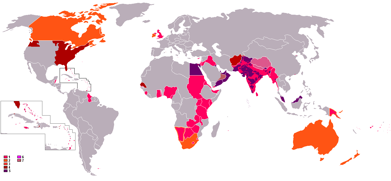
English: : An anachronous map of the British Empire (showing its many forms of control). The colours in the map key are explained according to their related numbers as follows:
|
| Date | 8 October 2006 (original upload date) |
| Source | Transferred from en.wikipedia to Commons. |
| Author | The original uploader was Gsd2000 at English Wikipedia. |
Licensing[edit]

|
Permission is granted to copy, distribute and/or modify this document under the terms of the GNU Free Documentation License, Version 1.2 or any later version published by the Free Software Foundation; with no Invariant Sections, no Front-Cover Texts, and no Back-Cover Texts. A copy of the license is included in the section entitled GNU Free Documentation License. |
| This file is licensed under the Creative Commons Attribution-Share Alike 3.0 Unported license. | ||
| ||
| This licensing tag was added to this file as part of the GFDL licensing update. |
Original upload log[edit]
The original description page was here. All following user names refer to en.wikipedia.
- 2006-10-08 13:08 Gsd2000 1357×628×8 (42019 bytes)
File history
Click on a date/time to view the file as it appeared at that time.
| Date/Time | Thumbnail | Dimensions | User | Comment | |
|---|---|---|---|---|---|
| current | 23:41, 7 November 2021 | | 1,357 × 628 (48 KB) | Randomastwritter (talk | contribs) | jubaland |
| 08:04, 31 October 2021 |  | 1,357 × 628 (48 KB) | Randomastwritter (talk | contribs) | . | |
| 19:47, 13 June 2009 |  | 1,357 × 628 (41 KB) | Mnmazur (talk | contribs) | Reverted to version as of 20:37, 20 September 2007 - Spheres of influnce extended beyond Tibet but did not cover the entire country. Firthermore, even if they had, that map uses current Chinese borders and therefore filling in the country just doesn't wo | |
| 13:01, 18 April 2008 |  | 1,357 × 628 (55 KB) | LaGrandefr~commonswiki (talk | contribs) | {{Information |Description= {{en}}: An anachronous map of the British Empire (showing its many forms of control). The colours in the map key are explained according to their related numbers as follows: *1.Pink: colonies held by 1945 *2.Orange:Dominions | |
| 20:37, 20 September 2007 |  | 1,357 × 628 (41 KB) | Tarret (talk | contribs) | {{Information |Description=An anachronous map of the British Empire (showing its many forms of control). The colours in the map key are explained according to their related numbers as follows: *1.Pink: colonies held by 1945 *2.Orange:Dominions *3.Pink in |
You cannot overwrite this file.
File usage on Commons
There are no pages that use this file.
File usage on other wikis
The following other wikis use this file:
- Usage on cs.wikipedia.org
- Usage on ro.wikipedia.org
- Usage on th.wikipedia.org