File:Brigner Road rail bridge.jpg
From Wikimedia Commons, the free media repository
Jump to navigation
Jump to search
Size of this preview: 800 × 547 pixels. Other resolutions: 320 × 219 pixels | 640 × 438 pixels | 1,024 × 700 pixels.
Original file (1,024 × 700 pixels, file size: 339 KB, MIME type: image/jpeg)
File information
Structured data
Captions
Camera location | 38° 59′ 47.5″ N, 82° 54′ 17″ W | View this and other nearby images on: OpenStreetMap | 38.996528; -82.904722 |
---|
DescriptionBrigner Road rail bridge.jpg |
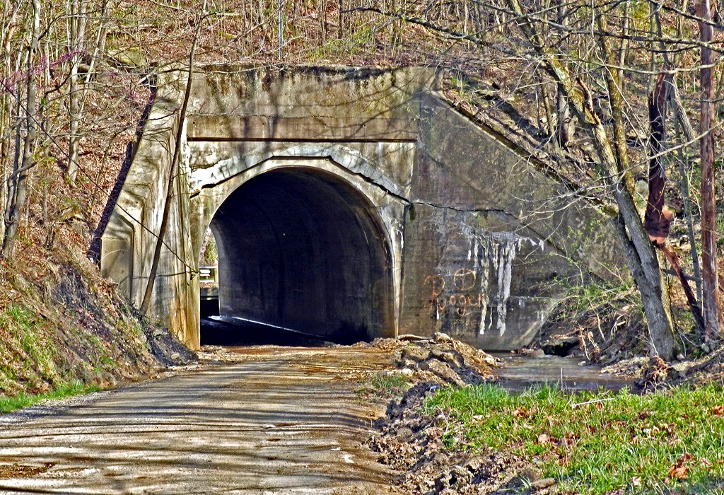
English: Tunnel carrying a CSX rail line over Brigner Road in central Union Township, Pike County, Ohio, United States. |
Date | Taken on 13 April 2011 |
Source | Flickr |
Author | Don O'Brien |
Permission (Reusing this file) |
This file is licensed under the Creative Commons Attribution 2.0 Generic license.
|
This image was originally posted to Flickr by dok1 at https://flickr.com/photos/51096110@N00/5627581936. It was reviewed on 16 August 2015 by FlickreviewR and was confirmed to be licensed under the terms of the cc-by-2.0. |
16 August 2015
File history
Click on a date/time to view the file as it appeared at that time.
Date/Time | Thumbnail | Dimensions | User | Comment | |
---|---|---|---|---|---|
current | 02:46, 16 August 2015 | 1,024 × 700 (339 KB) | Nyttend (talk | contribs) | {{Location|38|59|47.5|N|82|54|17|W}} {{Information |Description={{en|Tunnel carrying a CSX rail line over Brigner Road in central {{w|Union Township, Pike County, Ohio|Union Township}}, {{w|Pike County, Ohio|Pike County}}, {{w|Ohio}}, {{w|United States... |
You cannot overwrite this file.
File usage on Commons
The following page uses this file:
File usage on other wikis
The following other wikis use this file:
- Usage on en.wikipedia.org
- Usage on es.wikipedia.org
- Usage on eu.wikipedia.org
- Usage on fa.wikipedia.org
- Usage on pt.wikipedia.org
- Usage on ur.wikipedia.org
- Usage on vi.wikipedia.org
- Usage on www.wikidata.org
- Usage on zh.wikipedia.org
Metadata
This file contains additional information such as Exif metadata which may have been added by the digital camera, scanner, or software program used to create or digitize it. If the file has been modified from its original state, some details such as the timestamp may not fully reflect those of the original file. The timestamp is only as accurate as the clock in the camera, and it may be completely wrong.
Camera manufacturer | NIKON |
---|---|
Camera model | COOLPIX P500 |
Exposure time | 1/320 sec (0.003125) |
F-number | f/4.6 |
ISO speed rating | 160 |
Date and time of data generation | 01:42, 13 April 2011 |
Lens focal length | 17.7 mm |
Horizontal resolution | 300 dpi |
Vertical resolution | 300 dpi |
Software used | picnik.com |
File change date and time | 09:27, 17 April 2011 |
Y and C positioning | Centered |
Exposure Program | Normal program |
Exif version | 2.3 |
Date and time of digitizing | 01:42, 13 April 2011 |
Meaning of each component |
|
APEX exposure bias | 0 |
Maximum land aperture | 3.5310694906354 APEX (f/3.4) |
Metering mode | Pattern |
Light source | Unknown |
Flash | Flash did not fire, compulsory flash suppression |
Supported Flashpix version | 1 |
Color space | sRGB |
File source | Digital still camera |
Scene type | A directly photographed image |
Custom image processing | Normal process |
Exposure mode | Auto exposure |
White balance | Auto white balance |
Digital zoom ratio | 0 |
Focal length in 35 mm film | 100 mm |
Scene capture type | Standard |
Scene control | None |
Contrast | Normal |
Saturation | Normal |
Sharpness | Normal |
Subject distance range | Unknown |
Image compression mode | 4 |
Supported Flashpix version | 1 |
Image width | 1,024 px |
Image height | 700 px |
Date metadata was last modified | 05:27, 17 April 2011 |
Structured data
Items portrayed in this file
depicts
13 April 2011
38°59'47.501"N, 82°54'16.999"W
0.003125 second
4.6
17.7 millimetre
160
image/jpeg
0e76f6c5fff0d4e1cb647bf45ebd2c5a564e909a
346,991 byte
700 pixel
1,024 pixel
Hidden categories: