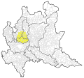
File:Brianza localizzazione.svg
From Wikimedia Commons, the free media repository
Jump to navigation
Jump to search

Size of this PNG preview of this SVG file: 504 × 475 pixels. Other resolutions: 255 × 240 pixels | 509 × 480 pixels | 815 × 768 pixels | 1,087 × 1,024 pixels | 2,173 × 2,048 pixels.
Original file (SVG file, nominally 504 × 475 pixels, file size: 11.81 MB)
File information
Structured data
Captions
Captions
Add a one-line explanation of what this file represents
Summary[edit]
| DescriptionBrianza localizzazione.svg |
Italiano: Area di localizzazione della Brianza (confini amministrativi aggiornati al 2019) |
| Date | |
| Source | Revisione immagine originale File:Comuni della Brianza.png. Confini comuni e provincie: ISTAT - confini delle unità amministrative a fini statistici al 1 gennaio 2019. Laghi: Regione Lombardia - Lago 10000 CT10. |
| Author | Utente:Mess, Utente:Sette-quattro |
Licensing[edit]
This file is licensed under the Creative Commons Attribution-Share Alike 4.0 International license.
- You are free:
- to share – to copy, distribute and transmit the work
- to remix – to adapt the work
- Under the following conditions:
- attribution – You must give appropriate credit, provide a link to the license, and indicate if changes were made. You may do so in any reasonable manner, but not in any way that suggests the licensor endorses you or your use.
- share alike – If you remix, transform, or build upon the material, you must distribute your contributions under the same or compatible license as the original.
This image was improved or created by the Wikigraphists of the Graphic Lab (it). You can propose images to clean up, improve, create or translate as well. |
Original upload log[edit]
The original description page was here. All following user names refer to it.wikipedia.
| Date/Time | Dimensions | User | Comment |
|---|---|---|---|
| 2014-03-04 16:16 | 280×260× (687506 bytes) | Mess | fix |
| 2014-03-03 11:45 | 280×260× (687465 bytes) | Mess | == Dettagli == {{Informazioni file |Descrizione = Area di localizzazione della Brianza (confini amministrativi aggiornati al 2014) |Fonte = [[:File:Comuni della Brianza.png]] e [[:File:Regions, provinces and municipalities in Italy.svg]] |Data = 3 marz... |
File history
Click on a date/time to view the file as it appeared at that time.
| Date/Time | Thumbnail | Dimensions | User | Comment | |
|---|---|---|---|---|---|
| current | 22:26, 24 June 2019 |  | 504 × 475 (11.81 MB) | Sette-quattro (talk | contribs) | Aggiornato stile come da progetto WikiProject Maps. Aggiornati confini amministrativi al 1° gennaio 2019. Aggiunti laghi principali. |
| 21:07, 2 February 2019 |  | 280 × 260 (671 KB) | Mess (talk | contribs) | Transferred from it.wikipedia via #commonshelper |
You cannot overwrite this file.
File usage on Commons
The following page uses this file:
File usage on other wikis
The following other wikis use this file:
- Usage on eo.wikipedia.org
- Usage on eu.wikipedia.org
- Usage on it.wikipedia.org
- Usage on it.wikivoyage.org
- Usage on lmo.wikipedia.org
- Usage on www.wikidata.org
Metadata
This file contains additional information such as Exif metadata which may have been added by the digital camera, scanner, or software program used to create or digitize it. If the file has been modified from its original state, some details such as the timestamp may not fully reflect those of the original file. The timestamp is only as accurate as the clock in the camera, and it may be completely wrong.
| Width | 504.486px |
|---|---|
| Height | 474.906px |
Structured data
25 June 2019
image/svg+xml
47ea06d0f3948091559eac3525ff6a92ce572ca9
12,385,530 byte
475 pixel
504 pixel
Hidden categories: