File:Breisgau zur Zeit der Karolinger Karte in "Badische Landes-Geschichte" v. Josef Bader, 1836.jpg
Original file (1,536 × 2,048 pixels, file size: 1.5 MB, MIME type: image/jpeg)
Captions
Summary[edit]
DescriptionBreisgau zur Zeit der Karolinger Karte in "Badische Landes-Geschichte" v. Josef Bader, 1836.jpg |
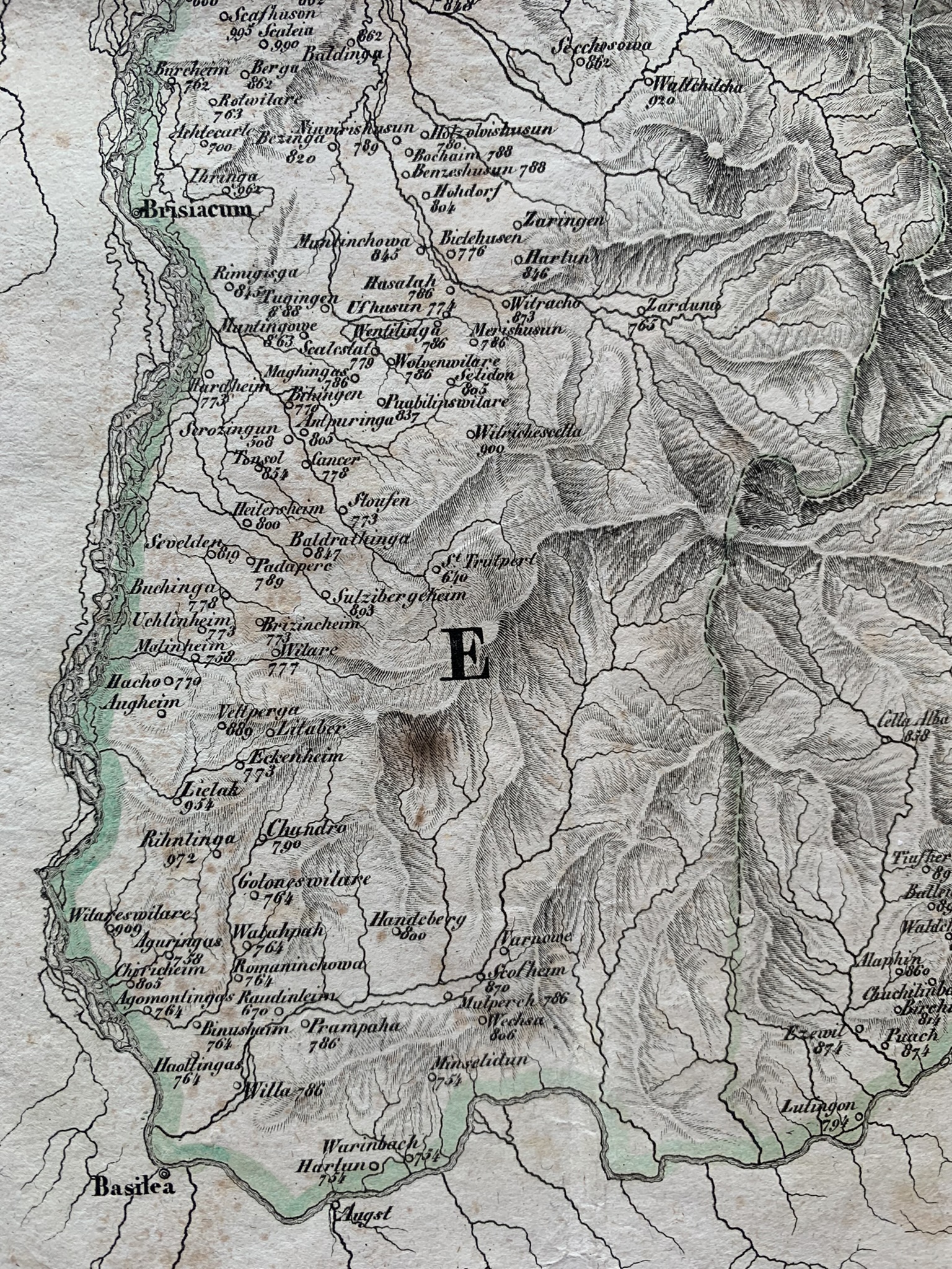
English: The SW part of the region of Breisgau in the times of the Carolingian dynasty; numbers beside names of places are years of the first documented mention of a given place. |
|||||
Date | or 1896 | |||||
Source | "Badische Landes-Geschichte" (published 1834) von Joseph Bader (1805–1883) | |||||
Author | DaLoetz | |||||
Permission (Reusing this file) |
|
Camera location | 47° 55′ 15.72″ N, 7° 47′ 02.65″ E | View this and other nearby images on: OpenStreetMap | 47.921033; 7.784069 |
---|
File history
Click on a date/time to view the file as it appeared at that time.
Date/Time | Thumbnail | Dimensions | User | Comment | |
---|---|---|---|---|---|
current | 14:04, 7 August 2022 | 1,536 × 2,048 (1.5 MB) | DaLoetz (talk | contribs) | Uploaded own work with UploadWizard |
You cannot overwrite this file.
File usage on Commons
The following page uses this file:
File usage on other wikis
The following other wikis use this file:
- Usage on pl.wikipedia.org
Metadata
This file contains additional information such as Exif metadata which may have been added by the digital camera, scanner, or software program used to create or digitize it. If the file has been modified from its original state, some details such as the timestamp may not fully reflect those of the original file. The timestamp is only as accurate as the clock in the camera, and it may be completely wrong.
Camera manufacturer | Apple |
---|---|
Camera model | iPhone XS |
Exposure time | 1/121 sec (0.0082644628099174) |
F-number | f/1.8 |
ISO speed rating | 50 |
Date and time of data generation | 18:08, 5 August 2022 |
Lens focal length | 4.25 mm |
Latitude | 47° 55′ 15.72″ N |
Longitude | 7° 47′ 2.65″ E |
Altitude | 314.609 meters above sea level |
Horizontal resolution | 72 dpi |
Vertical resolution | 72 dpi |
Software used | 15.5 |
File change date and time | 18:08, 5 August 2022 |
Y and C positioning | Centered |
Exposure Program | Normal program |
Exif version | 2.32 |
Date and time of digitizing | 18:08, 5 August 2022 |
Meaning of each component |
|
APEX shutter speed | 6.9236652898883 |
APEX aperture | 1.6959938128384 |
APEX brightness | 5.289968717414 |
APEX exposure bias | 0 |
Metering mode | Pattern |
Flash | Flash did not fire, compulsory flash suppression |
DateTimeOriginal subseconds | 176 |
DateTimeDigitized subseconds | 176 |
Supported Flashpix version | 1 |
Color space | Uncalibrated |
Sensing method | One-chip color area sensor |
Scene type | A directly photographed image |
Exposure mode | Auto exposure |
White balance | Auto white balance |
Focal length in 35 mm film | 26 mm |
Scene capture type | Standard |
Speed unit | Kilometers per hour |
Speed of GPS receiver | 0 |
Reference for direction of image | True direction |
Direction of image | 98.695480365522 |
Reference for bearing of destination | True direction |
Bearing of destination | 98.695480365522 |