File:Brazil, which Coast is a Portuguese Possession, Divided into Fourteen Captaincies, Showing the Middle of the Country Inhabited by Many Unknown Peoples WDL1200.png
Jump to navigation
Jump to search

Size of this preview: 800 × 545 pixels. Other resolutions: 320 × 218 pixels | 640 × 436 pixels | 1,024 × 698 pixels | 1,280 × 872 pixels | 1,503 × 1,024 pixels.
Original file (1,503 × 1,024 pixels, file size: 2.63 MB, MIME type: image/png)
Captions
Captions
Add a one-line explanation of what this file represents
Summary
[edit]
| Author |
Русский: Сансон, Николас (1600-1667)
Français : Sanson, Nicolas (1600-1667)
English: Sanson, Nicolas (1600-1667)
中文:桑松, 尼古拉斯 (1600-1667)
Português: Sanson, Nicolas (1600-1667)
العربية: سانسون، نيكولاس (1600-1667)
Español: Sanson, Nicolas (1600-1667) |
| Title |
Русский: Бразилия, побережье которой является португальским владением, разделенная на четырнадцать регионов; с изображением центрального региона страны, населенного различными неизвестными народами
Français : Le Brésil, dont la côte est une possession portugaise, divisée en quatorze capitaineries, montrant le centre du pays habité par un grand nombre de peuples inconnus
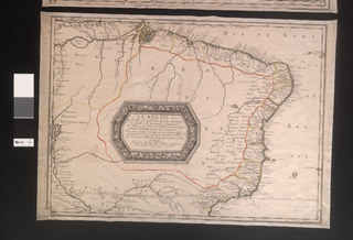
English: Brazil, which Coast is a Portuguese Possession, Divided into Fourteen Captaincies, Showing the Middle of the Country Inhabited by Many Unknown Peoples
中文:巴西分14个辖区,其海岸为葡萄牙人所占有,国家中央地带居住着众多人口,而且他们不为世人所知
Português: Brasil, Cuja Costa é de Posse Portuguesa, Dividido em Quatorze Capitanias, o Centro do País é habitado por Muitos Povos Quase Todos Eles Desconhecidos
العربية: تُقسم البرازيل، التي يقع ساحلها تحت الحيازة البرتغالية، إلى أربعة عشر قبطانية، ويظهر وسط البلاد الذي يسكنه أقوام مجهولون كثيرون
Español: Brasil, cuya costa es una posesión portuguesa, dividido en catorce capitanías, mostrando el centro del país habitado por muchos pueblos desconocidos |
| Description |
Русский: Данная карта побережья португальских владений в Бразилии была составлена одним из величайших французских картографов Николя Сансоном (1600-1667 гг.). Сансон давал уроки географии королям Луи XIII и Луи XIV. Кроме того, он был назначен королевским географом, и впоследствии двое его младших сыновей приняли от него это звание. До Сансона в области картографии главенствующую позицию занимали картографы Голландии, карты которых отличались скорее своей эстетикой, нежели точностью. Карты Сансона, которые отличались как точностью, так и элегантностью исполнения, ознаменовали собой переход влияния в сфере картографии от Нидерландов к Франции, что совпало с упадком морской мощи Нидерландов и усилением мирового влияния Франции. В отличие от ранних голландских карт, в картах Сансона большое внимание уделялось детальному изображению береговых линий и границам континентов.
Индейцы Южной Америки; Коренные народности; Иезуиты; Миссии Français : Cette carte de la côte portugaise Brésilienne a été réalisée par l'un des plus grands cartographes français, Nicolas Sanson (1600-67). Sanson a donné des leçons de géographie à la fois au roi Louis XIII et à Louis XIV. Il a également été nommé géographe officiel du roi, et ses deux jeunes fils lui ont succédé à ce poste. Jusqu'à Sanson, le domaine de la cartographie était dominée par les Hollandais, dont les cartes privilégiaient l'esthétique plutôt que l'exactitude. Les cartes de Sanson, étaient remarquables par leur précision et leur élégance, elles ont marqué un tournant dans le domaine de la cartographie des Pays-Bas jusqu'en France. Ceci coïncide avec le déclin de la domination maritime néerlandaise et l'avènement de la France en tant que puissance mondiale. À la différence des précédentes cartes néerlandaises, celles de Sanson étaient fortement axées sur les côtes et les frontières du continent.
Indiens d'Amérique du Sud; Peuples autochtones; Jésuites; Missions English: This coastal map of Portuguese Brazil is by one of the greatest of the French cartographers, Nicolas Sanson (1600-67). Sanson gave geography lessons to both King Louis XIII and King Louis XIV. He also was named official geographer to the king, and his two younger sons succeeded him in this position. Until Sanson, the field of cartography was dominated by the Dutch, whose maps favored aesthetics over exactness. Sanson’s maps, notable for accuracy as well as elegance, marked a shift in the dominance of the field of cartography from the Netherlands to France, one that coincided with the decline of Dutch naval prominence and the rise of France as a world power. Unlike the earlier Dutch maps, Sanson’s maps focused heavily on coastlines and continental boundaries.
Indians of South America; Indigenous peoples; Jesuits; Missions 中文:这幅葡属巴西海岸地图出自一位法国著名的制图师尼古拉斯·桑松(1600 - 67 年)。 桑松为国王路易十三和路易十四教授地理知识。 他还被国王任命为官方地理学家,他的两个小儿子继承了他的职位。 推崇美感胜过精确的荷兰地图在制图界占据了主导地位,直至桑松出现。 桑松的地图以准确与雅观而著称,他将制图界主导地位从荷兰转变到法国,期间正值荷兰海军实力衰退,而法国崛起成为一个世界大国。 不同于早期的荷兰地图,桑松的地图更加注重海岸线与大陆边界线。
南美洲印第安人; 土著居民; 耶稣会士; 传教 Português: Este mapa do litoral do Brasil português foi feito por um dos maiores cartógrafos franceses, Nicolas Sanson (1600-67). Sanson deu aulas de geografia para os reis Luís XIII e Luís XIV. Ele foi também nomeado geógrafo oficial do rei e seus dois filhos mais jovens o sucederam nesta função. Até Sanson, o campo da cartografia era dominado pelos holandeses, cujos mapas favoreciam mais a estética do que propriamente a exatidão. Os mapas de Sanson, famosos pela sua precisão, bem como pela sua elegância, representaram uma mudança na hegemonia do campo da cartografia, da Holanda para a França, mudança esta que coincidiu com o declínio da superioridade da marinha holandesa e a ascensão da França como potência mundial. Diferente dos mapas holandeses mais antigos, os mapas de Sanson tinham um enfoque marcante nas áreas costeiras e nas fronteiras continentais.
Índios da América do Sul; Povos indígenas; Jesuítas; Missões العربية: رسم هذه الخريطة الساحلية للبرازيل البرتغالية أحد أعظم رسامي الخرائط الفرنسيين، نيكولاس سانسون (1600-67). أعطى سانسون دروسا في الجغرافيا لكل من الملك لويس الثالث عشر والملك لويس الرابع عشر. كما عُين المسؤول الجغرافي للملك، وقد خلفه في هذا المنصب اثنان من أبنائه الصغار. وحتى ظهور سانسون، هيمن الهولنديون على مجال رسم الخرائط، وقد فضلوا الجوانب الجمالية على الدقة. تميزت خرائط سانسون بالدقة فضلا عن الأناقة، وسجلت تحولا في الهيمنة على مجال رسم الخرائط من هولندا إلى فرنسا، والتي تزامنت مع تراجع البحرية الهولندية وصعود فرنسا كقوة عالمية. وخلافا للخرائط الهولندية المبكرة، ركزت خرائط سانسون بشكل كبير على السواحل والحدود القارية.
هنود أمريكا الجنوبية; الشعوب الأصلية; اليسوعيون; الإرساليات التبشيرية Español: Este mapa de la costa del Brasil portugués es obra de uno de los mejores cartógrafos franceses, Nicolas Sanson (1600-67). Sanson dio lecciones de geografía tanto al rey Luis XIII como al rey Luis XIV. También fue nombrado geógrafo oficial del rey, y sus dos hijos pequeños lo sucedieron en este puesto. Hasta la llegada de Sanson, el campo de la cartografía estaba dominado por los holandeses, cuyos mapas daban más importancia a la estética que a la exactitud. Los mapas de Sanson, notables por su exactitud y elegancia, marcaron un cambio en el dominio en el campo de la cartografía desde los Países Bajos hacia Francia, que coincidió con el declive de la importancia naval holandesa y el surgimiento de Francia como potencia mundial. A diferencia de los anteriores mapas holandeses, los mapas de Sanson se concentraban principalmente en las costas y en los límites continentales.
Indios de América del Sur; Pueblos indígenas; Jesuitas; Misiones |
| Date | 1656 |
| Medium |
Русский: Карты
Français : Cartes
English: Maps
中文:地图
Português: Mapas
العربية: خرائط
Español: Mapas |
| Dimensions |
English: 1 hand colored map ; 39 x 54 centimeters |
| Collection |
Русский: Национальная библиотека Бразилии
Français : Bibliothèque nationale du Brésil
English: National Library of Brazil
中文:巴西国家图书馆
Português: Biblioteca Nacional do Brasil
العربية: مكتبة البرازيل الوطنية
Español: Biblioteca Nacional de Brasil |
| Place of creation |
Русский: Бразилия
Français : Brésil
English: Brazil
中文:巴西
Português: Brasil
العربية: البرازيل
Español: Brasil |
| Notes | Original language title: Le Bresil, dont la Coste est possedée par les Portugais et divisée en quatorze Capitanieres, le Milieu du Pays est habité par un trés grand Nombre de Peuples presque tous Incogneus |
| References | http://hdl.loc.gov/loc.wdl/brrjbn.1200 |
| Source/Photographer |
|
Licensing
[edit]
|
This is a faithful photographic reproduction of a two-dimensional, public domain work of art. The work of art itself is in the public domain for the following reason:
The official position taken by the Wikimedia Foundation is that "faithful reproductions of two-dimensional public domain works of art are public domain".
This photographic reproduction is therefore also considered to be in the public domain in the United States. In other jurisdictions, re-use of this content may be restricted; see Reuse of PD-Art photographs for details. | ||||
File history
Click on a date/time to view the file as it appeared at that time.
| Date/Time | Thumbnail | Dimensions | User | Comment | |
|---|---|---|---|---|---|
| current | 00:47, 11 March 2014 | | 1,503 × 1,024 (2.63 MB) | Fæ (talk | contribs) | =={{int:filedesc}}== {{Artwork |artist = |author ={{ru|1=Сансон, Николас (1600-1667)}} {{fr|1=Sanson, Nicolas (1600-1667)}} {{en|1=Sanson, Nicolas (1600-1667)}} {{zh|1=桑松, 尼古拉斯 (1600-1667)}} {{pt|1=Sanson, Nicolas (1600-1667)}}... |
You cannot overwrite this file.
File usage on Commons
The following page uses this file: